Map
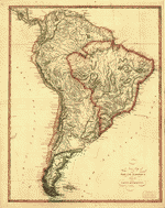
Paraguariæ Provinciæ soc. jesu cum adiacentibg. novissima descriptio : post iteratas peregrinationes & plures observationes patrum missionariorum eiusdem soc. tum huius provinciæ, cum & Peruanæ accuratissime delineata & emendata ann. 1732 /

| Format |
Map |
|---|---|
| Contributors |
Retz, Francisco |
| Dates |
1732 |
| Location |
South America |
| Language |
Latin |
| Subjects |
South America |
- Title
- Paraguariæ Provinciæ soc. jesu cum adiacentibg. novissima descriptio : post iteratas peregrinationes & plures observationes patrum missionariorum eiusdem soc. tum huius provinciæ, cum & Peruanæ accuratissime delineata & emendata ann. 1732 /
- Description
-
Shows Uruguay, Paraguay, and portions of Argentina, Chile, Peru, Bolivia, and Brazil.
-
Relief shown pictorially.
-
Some place names in Spanish.
-
Available also through the Library of Congress Web site as a raster image.
-
Copy annotated in black ink. DLC
-
Includes text.
-
1 map ; 66 x 52 cm.
- Creator
- Retz, Francisco.
- Created Published
-
[S.l. : s.n., 1732]
- Subject Headings
-
-
South America
-
-
South America.
- Notes
-
-
Shows Uruguay, Paraguay, and portions of Argentina, Chile, Peru, Bolivia, and Brazil.
-
-
Relief shown pictorially.
-
-
Some place names in Spanish.
-
-
Available also through the Library of Congress Web site as a raster image.
-
-
Copy annotated in black ink. DLC
-
-
Includes text.
- Medium
-
1 map ; 66 x 52 cm.
- Call Number
-
G5200 1732 .R4
- Repository
-
Library of Congress Geography and Map Division Washington, D.C. 20540-4650 USA dcu
- Digital Id
-
g5200 br000088 http://hdl.loc.gov/loc.gmd/g5200.br000088
- Library of Congress Catalog Number
- 2003683882
Rights & Access
The maps in the Map Collections materials were either published prior to 1922, produced by the United States government, or both (see catalogue records that accompany each map for information regarding date of publication and source). The Library of Congress is providing access to these materials for educational and research purposes and is not aware of any U.S. copyright protection (see Title 17 of the United States Code) or any other restrictions in the Map Collection materials.
Note that the written permission of the copyright owners and/or other rights holders (such as publicity and/or privacy rights) is required for distribution, reproduction, or other use of protected items beyond that allowed by fair use or other statutory exemptions. Responsibility for making an independent legal assessment of an item and securing any necessary permissions ultimately rests with persons desiring to use the item.
More about Copyright and other Restrictions
For guidance about compiling full citations consult Citing Primary Sources.
Part of...
-
General Maps
[2477]
-
Geography And Maps Division
[60803]
-
American Memory
[1121009]
More maps like this
-
-
 South America.
Contributor:
United States. Central Intelligence Agency
Site:
American Memory-cultural, Main Catalog
Original Format:
Map
Date:
2001
View catalog record
South America.
Contributor:
United States. Central Intelligence Agency
Site:
American Memory-cultural, Main Catalog
Original Format:
Map
Date:
2001
View catalog record
-
 South America.
Contributor:
United States. Central Intelligence Agency
Site:
American Memory-cultural, Main Catalog
Original Format:
Map
Date:
2000
View catalog record
South America.
Contributor:
United States. Central Intelligence Agency
Site:
American Memory-cultural, Main Catalog
Original Format:
Map
Date:
2000
View catalog record
-
 Mapa de parte de los virreynatos de Buenos Aires, Lima, Sta. Fe y capitania gral. de Caracas en la America meridional con las colonias portuguesas ...
Contributor:
Requena, Francisco
Site:
American Memory-cultural, Main Catalog
Original Format:
Map
Date:
1796
View catalog record
Mapa de parte de los virreynatos de Buenos Aires, Lima, Sta. Fe y capitania gral. de Caracas en la America meridional con las colonias portuguesas ...
Contributor:
Requena, Francisco
Site:
American Memory-cultural, Main Catalog
Original Format:
Map
Date:
1796
View catalog record
-
 New map of South America from the latest authorities.
Site:
American Memory-cultural, Main Catalog
Original Format:
Map
View catalog record
New map of South America from the latest authorities.
Site:
American Memory-cultural, Main Catalog
Original Format:
Map
View catalog record
-
 A new map of South America, shewing it's general divisions, chief cities & towns, rivers, mountains &c. /
Contributor:
Wells, Edward
Site:
American Memory-cultural, Main Catalog
Original Format:
Map
Date:
1700
View catalog record
A new map of South America, shewing it's general divisions, chief cities & towns, rivers, mountains &c. /
Contributor:
Wells, Edward
Site:
American Memory-cultural, Main Catalog
Original Format:
Map
Date:
1700
View catalog record
-
 Typus geographicus, Chili a Paraguay Freti Magellanici &c. /
Contributor:
Ovalle, Alonso de
Site:
American Memory-cultural, Main Catalog
Original Format:
Map
Date:
1733
View catalog record
Typus geographicus, Chili a Paraguay Freti Magellanici &c. /
Contributor:
Ovalle, Alonso de
Site:
American Memory-cultural, Main Catalog
Original Format:
Map
Date:
1733
View catalog record
-
 South America.
Contributor:
United States. Central Intelligence Agency
Site:
American Memory-cultural, Main Catalog
Original Format:
Map
Date:
2004
View catalog record
South America.
Contributor:
United States. Central Intelligence Agency
Site:
American Memory-cultural, Main Catalog
Original Format:
Map
Date:
2004
View catalog record
-
 South America.
Contributor:
United States. Central Intelligence Agency
Site:
American Memory-cultural, Main Catalog
Original Format:
Map
Date:
1998
View catalog record
South America.
Contributor:
United States. Central Intelligence Agency
Site:
American Memory-cultural, Main Catalog
Original Format:
Map
Date:
1998
View catalog record
-
 Mapa de una parte de la America Meridional en que se manifiestan los paises pertenecientes al Nuebo Reyno de Granada y Capitania General de Caracas ...
Contributor:
Requena, Francisco
Site:
American Memory-cultural, Main Catalog
Original Format:
Map
Date:
1783
View catalog record
Mapa de una parte de la America Meridional en que se manifiestan los paises pertenecientes al Nuebo Reyno de Granada y Capitania General de Caracas ...
Contributor:
Requena, Francisco
Site:
American Memory-cultural, Main Catalog
Original Format:
Map
Date:
1783
View catalog record
-
 Map of South America According to the Latest and Best Authorities.
Contributor:
Finley, A.
Site:
American Memory-cultural, Main Catalog
Original Format:
Map
Date:
1826
View catalog record
Map of South America According to the Latest and Best Authorities.
Contributor:
Finley, A.
Site:
American Memory-cultural, Main Catalog
Original Format:
Map
Date:
1826
View catalog record
-
 Typus geographicus, Chili, Paraguay Freti Magellanici &c. /
Contributor:
Ovalle, Alonso de
Site:
American Memory-cultural, Main Catalog
Original Format:
Map
Date:
1733
View catalog record
Typus geographicus, Chili, Paraguay Freti Magellanici &c. /
Contributor:
Ovalle, Alonso de
Site:
American Memory-cultural, Main Catalog
Original Format:
Map
Date:
1733
View catalog record
-
 South America.
Contributor:
United States. Central Intelligence Agency
Site:
American Memory-cultural, Main Catalog
Original Format:
Map
Date:
2002
View catalog record
South America.
Contributor:
United States. Central Intelligence Agency
Site:
American Memory-cultural, Main Catalog
Original Format:
Map
Date:
2002
View catalog record
-
 South America.
Contributor:
United States. Central Intelligence Agency
Site:
American Memory-cultural, Main Catalog
Original Format:
Map
Date:
2005
View catalog record
South America.
Contributor:
United States. Central Intelligence Agency
Site:
American Memory-cultural, Main Catalog
Original Format:
Map
Date:
2005
View catalog record
-

 David Rumsey map collection
Contributor:
Rumsey, David
Site:
Main Catalog
Original Format:
Map
Date:
2002
David Rumsey map collection
Contributor:
Rumsey, David
Site:
Main Catalog
Original Format:
Map
Date:
2002
-
 Nova et exacta delineatio Americae partis avstralis. qve est : Brasilia, Caribana, Gviana regnũm noũũm, Castilia del Oro, Nicaragva, insũlae Antillas et Perv. Et sub ...
Contributor:
Hulsius, Levinus
Site:
American Memory-cultural, Main Catalog
Original Format:
Map
Date:
1692
View catalog record
Nova et exacta delineatio Americae partis avstralis. qve est : Brasilia, Caribana, Gviana regnũm noũũm, Castilia del Oro, Nicaragva, insũlae Antillas et Perv. Et sub ...
Contributor:
Hulsius, Levinus
Site:
American Memory-cultural, Main Catalog
Original Format:
Map
Date:
1692
View catalog record
You might also like
-
 Norsk skiløobere i Sydamerika.
Contributor:
Johansen, K. J.
Site:
Main Catalog
Original Format:
Book
Date:
1892
Norsk skiløobere i Sydamerika.
Contributor:
Johansen, K. J.
Site:
Main Catalog
Original Format:
Book
Date:
1892
-
The continent of opportunity; the South American republics--their history, their resources, their outlook. Together with a traveller's impressions of present day conditions,
Contributor:
Clark, Francis E.
Site:
Main Catalog
Original Format:
Book
Date:
1907
-
A commercial traveller in South America; being the experiences and impressions of an American business man on a trip through Panama, Ecuador, Peru, Chile, the ...
Contributor:
Wiborg, Frank Bestow
Site:
Main Catalog
Original Format:
Book
Date:
1905
-
South American impressions; being a series of newspaper articles
Contributor:
Woodruff, George
Site:
Main Catalog
Original Format:
Book
Date:
1910
-
What a woman saw in South America,
Contributor:
Foster, Cornelia Ely de Zeng
Site:
Main Catalog
Original Format:
Book
Date:
1913
-
South America: topical outlines for twenty club meetings, with bibliography;
Contributor:
Bacon, Corinne
Site:
Main Catalog
Original Format:
Book
Date:
1915