Map
Palestina, siue Terræ Sanctæ descriptio /

| Format |
Map |
|---|---|
| Contributors |
Jansson, Jan |
| Dates |
1650 |
| Location |
Israel Palestine |
| Language |
Latin |
| Subjects |
Bible Geography Israel O.T. Palestine |
- Title
- Palestina, siue Terræ Sanctæ descriptio /
- Description
-
Relief shown pictorially.
-
Oriented with north to the left.
-
Includes an inset view of Jerusalem and 18 indexed biblical scenes at top and bottom of sheet.
-
Exhibition: Jordanian Display, Library of Congress, Washington, D.C., May 25-27, 2005. DLC
-
Available also through the Library of Congress Web site as a raster image.
-
1 map : col. ; 27 x 56 cm.
- Creator
- Jansson, Jan,
- Created Published
-
Amstelodami : [s.n., 1650?]
- Subject Headings
-
-
Bible.--O.T.--Geography
-
-
Palestine
-
-
Israel
-
-
Palestine.
-
-
Israel.
- Notes
-
-
Relief shown pictorially.
-
-
Oriented with north to the left.
-
-
Includes an inset view of Jerusalem and 18 indexed biblical scenes at top and bottom of sheet.
-
-
Exhibition: Jordanian Display, Library of Congress, Washington, D.C., May 25-27, 2005. DLC
-
-
Available also through the Library of Congress Web site as a raster image.
- Medium
-
1 map : col. ; 27 x 56 cm.
- Call Number
-
G7481.2 1650 .J3
- Repository
-
Library of Congress Geography and Map Division Washington, D.C. 20540-4650 USA dcu
- Digital Id
-
g74812 ct001380 http://hdl.loc.gov/loc.gmd/g74812.ct001380
- Library of Congress Catalog Number
- 2005625327
Rights & Access
The maps in the Map Collections materials were either published prior to 1922, produced by the United States government, or both (see catalogue records that accompany each map for information regarding date of publication and source). The Library of Congress is providing access to these materials for educational and research purposes and is not aware of any U.S. copyright protection (see Title 17 of the United States Code) or any other restrictions in the Map Collection materials.
Note that the written permission of the copyright owners and/or other rights holders (such as publicity and/or privacy rights) is required for distribution, reproduction, or other use of protected items beyond that allowed by fair use or other statutory exemptions. Responsibility for making an independent legal assessment of an item and securing any necessary permissions ultimately rests with persons desiring to use the item.
More about Copyright and other Restrictions
For guidance about compiling full citations consult Citing Primary Sources.
Part of...
-
General Maps
[2477]
-
Geography And Maps Division
[60803]
-
American Memory
[1121009]
More maps like this
-
 Iudæa seu Terra Sancta, quæ Hebræorum sive Israelitarum in suas duodecim tribus divisa : secretis ab invicem Regnis Iuda et Israel expressis insuper sex ultimi ...
Contributor:
Jaillot, Alexis Hubert
Site:
American Memory-cultural, Main Catalog
Original Format:
Map
Date:
1696
View catalog record
Iudæa seu Terra Sancta, quæ Hebræorum sive Israelitarum in suas duodecim tribus divisa : secretis ab invicem Regnis Iuda et Israel expressis insuper sex ultimi ...
Contributor:
Jaillot, Alexis Hubert
Site:
American Memory-cultural, Main Catalog
Original Format:
Map
Date:
1696
View catalog record
-
 La Palestine, les tribus, et Jerusalem.
Contributor:
Anville, Jean Baptiste Bourguignon d
Site:
American Memory-cultural, Main Catalog
Original Format:
Map
Date:
1783
View catalog record
La Palestine, les tribus, et Jerusalem.
Contributor:
Anville, Jean Baptiste Bourguignon d
Site:
American Memory-cultural, Main Catalog
Original Format:
Map
Date:
1783
View catalog record
-
 Terra sancta sive promissionis, olim Palestina recens delineata, et in lucem edita per Nicolaum Visscher.
Contributor:
Visscher, Nicolaes
Site:
American Memory-cultural, Main Catalog
Original Format:
Map
Date:
1659
View catalog record
Terra sancta sive promissionis, olim Palestina recens delineata, et in lucem edita per Nicolaum Visscher.
Contributor:
Visscher, Nicolaes
Site:
American Memory-cultural, Main Catalog
Original Format:
Map
Date:
1659
View catalog record
-
 Das heilig Lande mit Ausztheilung der zwoelff Geschlechter.
Contributor:
Münster, Sebastian, Münster, Sebastian
Site:
American Memory-cultural, Main Catalog
Original Format:
Map
Date:
1588
View catalog record
Das heilig Lande mit Ausztheilung der zwoelff Geschlechter.
Contributor:
Münster, Sebastian, Münster, Sebastian
Site:
American Memory-cultural, Main Catalog
Original Format:
Map
Date:
1588
View catalog record
-
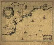 Nova Anglia, Novvm Belgivm et Virginia.
Contributor:
Jansson, Jan
Site:
American Memory-cultural, Main Catalog
Original Format:
Map
Date:
1642
View catalog record
Nova Anglia, Novvm Belgivm et Virginia.
Contributor:
Jansson, Jan
Site:
American Memory-cultural, Main Catalog
Original Format:
Map
Date:
1642
View catalog record
-
 America Septentrionalis /
Contributor:
Jansson, Jan
Site:
American Memory-cultural, Main Catalog
Original Format:
Map
Date:
1652
View catalog record
America Septentrionalis /
Contributor:
Jansson, Jan
Site:
American Memory-cultural, Main Catalog
Original Format:
Map
Date:
1652
View catalog record
-
 Nova et accurata tabula episcopatvvm Stavangeriensis, Bergensis et Asloiensis /
Contributor:
Jansson, Jan
Site:
American Memory-cultural, Main Catalog
Original Format:
Map
View catalog record
Nova et accurata tabula episcopatvvm Stavangeriensis, Bergensis et Asloiensis /
Contributor:
Jansson, Jan
Site:
American Memory-cultural, Main Catalog
Original Format:
Map
View catalog record
-
 Korte beschryvinge van de landschappen des werelts enz.
Contributor:
Visscher, Nicolaes
Site:
American Memory-cultural, Main Catalog
Original Format:
Map
Date:
1660
View catalog record
Korte beschryvinge van de landschappen des werelts enz.
Contributor:
Visscher, Nicolaes
Site:
American Memory-cultural, Main Catalog
Original Format:
Map
Date:
1660
View catalog record
-
 Carte de la Terre Promise.
Contributor:
Liebaux
Site:
American Memory-cultural, Main Catalog
Original Format:
Map
Date:
1720
View catalog record
Carte de la Terre Promise.
Contributor:
Liebaux
Site:
American Memory-cultural, Main Catalog
Original Format:
Map
Date:
1720
View catalog record
-
 Terræ Sanctæ, qua Promissionis terra, est Syriæ pars ea, quæ Palæstina uocatur.
Contributor:
Stella, Tilemann
Site:
American Memory-cultural, Main Catalog
Original Format:
Map
Date:
1600
View catalog record
Terræ Sanctæ, qua Promissionis terra, est Syriæ pars ea, quæ Palæstina uocatur.
Contributor:
Stella, Tilemann
Site:
American Memory-cultural, Main Catalog
Original Format:
Map
Date:
1600
View catalog record
-
 Canaan, or The Land of promise.
Contributor:
Moxon, Joseph
Site:
American Memory-cultural, Main Catalog
Original Format:
Map
Date:
1700
View catalog record
Canaan, or The Land of promise.
Contributor:
Moxon, Joseph
Site:
American Memory-cultural, Main Catalog
Original Format:
Map
Date:
1700
View catalog record
-
 An accurate map of the Holy Land Divided into the XII Tribes of Israel. Accomodated to Sacred History, & describing the Travels of Jesus Christ.
Contributor:
Bowen, Emanuel
Site:
American Memory-cultural, Main Catalog
Original Format:
Map
Date:
1752
View catalog record
An accurate map of the Holy Land Divided into the XII Tribes of Israel. Accomodated to Sacred History, & describing the Travels of Jesus Christ.
Contributor:
Bowen, Emanuel
Site:
American Memory-cultural, Main Catalog
Original Format:
Map
Date:
1752
View catalog record
-
 Terra Sancta que in Sacris Terra Promissionis ol : Palestina.
Contributor:
L'Isle, Guillaume de
Site:
American Memory-cultural, Main Catalog
Original Format:
Map
Date:
1782
View catalog record
Terra Sancta que in Sacris Terra Promissionis ol : Palestina.
Contributor:
L'Isle, Guillaume de
Site:
American Memory-cultural, Main Catalog
Original Format:
Map
Date:
1782
View catalog record
-
 [Sketch map of Palestine].
Site:
American Memory-cultural, Main Catalog
Original Format:
Map
View catalog record
[Sketch map of Palestine].
Site:
American Memory-cultural, Main Catalog
Original Format:
Map
View catalog record
-
 Ivdaea sev Palaestina ob sacratissima Redemtoris vestigia hodie dicta Terra Sancta.
Contributor:
Homann, Johann Baptist
Site:
American Memory-cultural, Main Catalog
Original Format:
Map
Date:
1748
View catalog record
Ivdaea sev Palaestina ob sacratissima Redemtoris vestigia hodie dicta Terra Sancta.
Contributor:
Homann, Johann Baptist
Site:
American Memory-cultural, Main Catalog
Original Format:
Map
Date:
1748
View catalog record
-
 Terra Sancta sive Palæstina exhibens no folum Regna vetera Iuda et Israel in fuas XII Tribus diftincta, fed etiam eorundem diverfarum ætatum conditionem et facta ...
Contributor:
Lotter, Tobias Conrad
Site:
American Memory-cultural, Main Catalog
Original Format:
Map
Date:
1759
View catalog record
Terra Sancta sive Palæstina exhibens no folum Regna vetera Iuda et Israel in fuas XII Tribus diftincta, fed etiam eorundem diverfarum ætatum conditionem et facta ...
Contributor:
Lotter, Tobias Conrad
Site:
American Memory-cultural, Main Catalog
Original Format:
Map
Date:
1759
View catalog record
You might also like
-

 Shirat ha-Tanakh shirim be-hashraʼat ma-mekorot = Songs of the Bible : songs inspired by the Tanakh.
Site:
Main Catalog
Original Format:
Audio
Date:
2008
Shirat ha-Tanakh shirim be-hashraʼat ma-mekorot = Songs of the Bible : songs inspired by the Tanakh.
Site:
Main Catalog
Original Format:
Audio
Date:
2008
-
 Scripture geography; or, A companion to the Bible: being a geographical and historical account of the places mentioned in the Holy Scripture ... Intended for ...
Contributor:
Smiley, Thomas T.
Site:
Main Catalog
Original Format:
Book
Date:
1834
Scripture geography; or, A companion to the Bible: being a geographical and historical account of the places mentioned in the Holy Scripture ... Intended for ...
Contributor:
Smiley, Thomas T.
Site:
Main Catalog
Original Format:
Book
Date:
1834
-
Sacred geography, and antiquities ...
Contributor:
Barrows, E. P.
Site:
Main Catalog
Original Format:
Book
Date:
1872
-
An historical geography of the Bible.
Contributor:
Coleman, Lyman
Site:
Main Catalog
Original Format:
Book
Date:
1850
-
Scripture geography ; or, A companion to the Bible : being a geographical and historical account of the places mentioned in the Holy Scriptures ...
Contributor:
Smiley, Thomas T.
Site:
Main Catalog
Original Format:
Book
Date:
1837
-
Gab es ein davidisch-salomonisches Grossreich? : Forschungsgeschichte und neuere Argumentationen aus der Sicht der Archäologie /
Contributor:
Huber, Michael
Site:
Main Catalog
Original Format:
Book
Date:
2010