Map
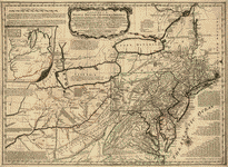
A map of the most inhabited part of New England; containing the provinces of Massachusets Bay and New Hampshire, with the colonies of Konektikut and Rhode Island, divided into counties and townships: The whole composed from actual surveys and its situation adjusted by astronomical observations.
Views

More Views

| Format |
Map |
|---|---|
| Contributors |
Jefferys, Thomas |
| Dates |
1755 |
| Location |
New England United States |
| Language |
English |
| Subjects |
New England United States |
- Title
- A map of the most inhabited part of New England; containing the provinces of Massachusets Bay and New Hampshire, with the colonies of Konektikut and Rhode Island, divided into counties and townships: The whole composed from actual surveys and its situation adjusted by astronomical observations.
- Description
-
Scale ca. 1:440,000.
-
Hand colored.
-
Prime meridian: London and Ferro.
-
Relief shown pictorially.
-
Includes compilation data and insets of "Fort Frederik," ca. 1:1,680 and "A plan of Boston Harbor from an accurate survey," ca. 1:150,000.
-
LC Maps of North America, 1750-1789, 797
-
Available also through the Library of Congress Web site as a raster image.
-
col. map 105 x 99 cm.
- Creator
- Jefferys, Thomas,
- Created Published
-
[London] Thos. Jefferys, 1755.
- Subject Headings
-
-
New England
-
-
United States--New England.
- Notes
-
-
Scale ca. 1:440,000.
-
-
Hand colored.
-
-
Prime meridian: London and Ferro.
-
-
Relief shown pictorially.
-
-
Includes compilation data and insets of "Fort Frederik," ca. 1:1,680 and "A plan of Boston Harbor from an accurate survey," ca. 1:150,000.
-
-
LC Maps of North America, 1750-1789, 797
-
-
Available also through the Library of Congress Web site as a raster image.
- Medium
-
col. map 105 x 99 cm.
- Call Number
-
G3720 1755 .J4
- Repository
-
Library of Congress Geography and Map Division Washington, D.C. 20540-4650 USA dcu
- Digital Id
-
g3720 ar079700 http://hdl.loc.gov/loc.gmd/g3720.ar079700
-
g3720 ar079701 http://hdl.loc.gov/loc.gmd/g3720.ar079701
- Library of Congress Catalog Number
- 74692155
Rights & Access
The maps in the Map Collections materials were either published prior to 1922, produced by the United States government, or both (see catalogue records that accompany each map for information regarding date of publication and source). The Library of Congress is providing access to these materials for educational and research purposes and is not aware of any U.S. copyright protection (see Title 17 of the United States Code) or any other restrictions in the Map Collection materials.
Note that the written permission of the copyright owners and/or other rights holders (such as publicity and/or privacy rights) is required for distribution, reproduction, or other use of protected items beyond that allowed by fair use or other statutory exemptions. Responsibility for making an independent legal assessment of an item and securing any necessary permissions ultimately rests with persons desiring to use the item.
More about Copyright and other Restrictions
For guidance about compiling full citations consult Citing Primary Sources.
Part of...
More maps like this
-
 A map of the most inhabited part of New England, containing the provinces of Massachusets Bay and New Hampshire, with the colonies of Conecticut and ...
Contributor:
Jefferys, Thomas
Site:
American Memory-cultural, Main Catalog
Original Format:
Map
Date:
1774
View catalog record
A map of the most inhabited part of New England, containing the provinces of Massachusets Bay and New Hampshire, with the colonies of Conecticut and ...
Contributor:
Jefferys, Thomas
Site:
American Memory-cultural, Main Catalog
Original Format:
Map
Date:
1774
View catalog record
-
 A map of the most inhabited part of New England, containing the provinces of Massachusets Bay and New Hampshire, with the colonies of Conecticut and ...
Contributor:
Jefferys, Thomas
Site:
American Memory-cultural, Main Catalog
Original Format:
Map
View catalog record
A map of the most inhabited part of New England, containing the provinces of Massachusets Bay and New Hampshire, with the colonies of Conecticut and ...
Contributor:
Jefferys, Thomas
Site:
American Memory-cultural, Main Catalog
Original Format:
Map
View catalog record
-
 A map of the most inhabited part of New England, containing the provinces of Massachusets Bay and New Hampshire, with the colonies of Conecticut and ...
Contributor:
Jefferys, Thomas
Site:
American Memory-cultural, Main Catalog
Original Format:
Map
Date:
1774
View catalog record
A map of the most inhabited part of New England, containing the provinces of Massachusets Bay and New Hampshire, with the colonies of Conecticut and ...
Contributor:
Jefferys, Thomas
Site:
American Memory-cultural, Main Catalog
Original Format:
Map
Date:
1774
View catalog record
-
 A new map of Nova Scotia, and Cape Breton Island with the adjacent parts of New England and Canada, composed from a great number of ...
Contributor:
Jefferys, Thomas
Site:
American Memory-cultural, Main Catalog
Original Format:
Map
Date:
1775
View catalog record
A new map of Nova Scotia, and Cape Breton Island with the adjacent parts of New England and Canada, composed from a great number of ...
Contributor:
Jefferys, Thomas
Site:
American Memory-cultural, Main Catalog
Original Format:
Map
Date:
1775
View catalog record
-
 A general map of the middle British colonies in America: Viz. Virginia, Maryland, Delaware, Pensilvania, New-Jersey, New-York, Connecticut, and Rhode-Island: Of Aquanishuonîgy the country of ...
Contributor:
Jefferys, Thomas
Site:
American Memory-cultural, Main Catalog
Original Format:
Map
Date:
1758
View catalog record
A general map of the middle British colonies in America: Viz. Virginia, Maryland, Delaware, Pensilvania, New-Jersey, New-York, Connecticut, and Rhode-Island: Of Aquanishuonîgy the country of ...
Contributor:
Jefferys, Thomas
Site:
American Memory-cultural, Main Catalog
Original Format:
Map
Date:
1758
View catalog record
-
 A map of Canada and the north part of Louisiana with the adjacent countrys.
Contributor:
Jefferys, Thomas
Site:
American Memory-cultural, Main Catalog
Original Format:
Map
Date:
1768
View catalog record
A map of Canada and the north part of Louisiana with the adjacent countrys.
Contributor:
Jefferys, Thomas
Site:
American Memory-cultural, Main Catalog
Original Format:
Map
Date:
1768
View catalog record
-
 Plan of New Orleans the capital of Louisiana; with the disposition of its quarters and canals as they have been traced by Mr. de la ...
Contributor:
Jefferys, Thomas
Site:
American Memory-cultural, Main Catalog
Original Format:
Map
Date:
1759
View catalog record
Plan of New Orleans the capital of Louisiana; with the disposition of its quarters and canals as they have been traced by Mr. de la ...
Contributor:
Jefferys, Thomas
Site:
American Memory-cultural, Main Catalog
Original Format:
Map
Date:
1759
View catalog record
-
 A map of Canada and the north part of Louisiana with the adjacent countrys.
Contributor:
Jefferys, Thomas
Site:
American Memory-cultural, Main Catalog
Original Format:
Map
Date:
1768
View catalog record
A map of Canada and the north part of Louisiana with the adjacent countrys.
Contributor:
Jefferys, Thomas
Site:
American Memory-cultural, Main Catalog
Original Format:
Map
Date:
1768
View catalog record
-
 Plan of New Orleans the capital of Louisiana; with the disposition of its quarters and canals as they have been traced by Mr. de la ...
Contributor:
Jefferys, Thomas
Site:
American Memory-cultural, Main Catalog
Original Format:
Map
Date:
1759
View catalog record
Plan of New Orleans the capital of Louisiana; with the disposition of its quarters and canals as they have been traced by Mr. de la ...
Contributor:
Jefferys, Thomas
Site:
American Memory-cultural, Main Catalog
Original Format:
Map
Date:
1759
View catalog record
-
 [Plan of the town and harbour of St. Augustine.
Contributor:
Jefferys, Thomas
Site:
American Memory-cultural, Main Catalog
Original Format:
Map
Date:
1762
View catalog record
[Plan of the town and harbour of St. Augustine.
Contributor:
Jefferys, Thomas
Site:
American Memory-cultural, Main Catalog
Original Format:
Map
Date:
1762
View catalog record
-
 Plan of Amelia Island in East Florida, north point of Amelia Island lyes in 30:55 north latitude 80:23 w. longitude from London, taken from De ...
Contributor:
Jefferys, Thomas
Site:
American Memory-cultural, Main Catalog
Original Format:
Map
Date:
1777
View catalog record
Plan of Amelia Island in East Florida, north point of Amelia Island lyes in 30:55 north latitude 80:23 w. longitude from London, taken from De ...
Contributor:
Jefferys, Thomas
Site:
American Memory-cultural, Main Catalog
Original Format:
Map
Date:
1777
View catalog record
-
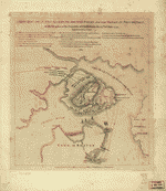 A sketch of the action between the British forces and the American provincials, on the heights of the peninsula of Charlestown, the 17th of June ...
Contributor:
Jefferys, Thomas
Site:
American Memory-cultural, Main Catalog
Original Format:
Map
Date:
1775
View catalog record
A sketch of the action between the British forces and the American provincials, on the heights of the peninsula of Charlestown, the 17th of June ...
Contributor:
Jefferys, Thomas
Site:
American Memory-cultural, Main Catalog
Original Format:
Map
Date:
1775
View catalog record
-
 An authentic plan of the town and harbour of Cap-François in the isle of St. Domingo.
Contributor:
Jefferys, Thomas
Site:
American Memory-cultural, Main Catalog
Original Format:
Map
Date:
1760
View catalog record
An authentic plan of the town and harbour of Cap-François in the isle of St. Domingo.
Contributor:
Jefferys, Thomas
Site:
American Memory-cultural, Main Catalog
Original Format:
Map
Date:
1760
View catalog record
-
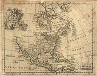 North America.
Contributor:
Jefferys, Thomas
Site:
American Memory-cultural, Main Catalog
Original Format:
Map
Date:
1750
View catalog record
North America.
Contributor:
Jefferys, Thomas
Site:
American Memory-cultural, Main Catalog
Original Format:
Map
Date:
1750
View catalog record
You might also like
-

 Reauthorization of the Magnuson-Stevens Fishery Conservation and Management Act : field hearing before the Subcommittee on Oceans and Fisheries of the Committee on Commerce, Science, ...
Contributor:
United States. Congress. Senate. Committee on Commerce, Science, and Transportation. Subcommittee on Oceans and Fisheries
Site:
Main Catalog
Original Format:
Book
Date:
1999-09-25
Reauthorization of the Magnuson-Stevens Fishery Conservation and Management Act : field hearing before the Subcommittee on Oceans and Fisheries of the Committee on Commerce, Science, ...
Contributor:
United States. Congress. Senate. Committee on Commerce, Science, and Transportation. Subcommittee on Oceans and Fisheries
Site:
Main Catalog
Original Format:
Book
Date:
1999-09-25
-
 Peaceful New England harbor
Contributor:
Highsmith, Carol M.
Site:
Prints & Photographs, Main Catalog
Original Format:
Photo, Print, Drawing
Date:
1980
View catalog record
Peaceful New England harbor
Contributor:
Highsmith, Carol M.
Site:
Prints & Photographs, Main Catalog
Original Format:
Photo, Print, Drawing
Date:
1980
View catalog record
-
 New England harbor and old wooden pier
Contributor:
Highsmith, Carol M.
Site:
Prints & Photographs, Main Catalog
Original Format:
Photo, Print, Drawing
Date:
1980
View catalog record
New England harbor and old wooden pier
Contributor:
Highsmith, Carol M.
Site:
Prints & Photographs, Main Catalog
Original Format:
Photo, Print, Drawing
Date:
1980
View catalog record
-
 New England harbor scene
Contributor:
Highsmith, Carol M.
Site:
Prints & Photographs, Main Catalog
Original Format:
Photo, Print, Drawing
Date:
1980
View catalog record
New England harbor scene
Contributor:
Highsmith, Carol M.
Site:
Prints & Photographs, Main Catalog
Original Format:
Photo, Print, Drawing
Date:
1980
View catalog record
-
Oldtown fireside stories /
Contributor:
Stowe, Harriet Beecher
Site:
Main Catalog
Original Format:
Book
Date:
1872
-
A family flight around home,
Contributor:
Hale, Edward Everett
Site:
Main Catalog
Original Format:
Book
Date:
1884