Map
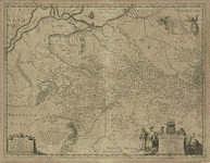
Delineatio generalis Camporum Desertorum vulgo Ukraina : cum adjacentibus provinciis /

| Format |
Map |
|---|---|
| Contributors |
Beauplan, Guillaume Le Vasseur |
| Dates |
1648 |
| Location |
Ukraine |
| Language |
Latin |
| Subjects |
Ukraine |
- Title
- Delineatio generalis Camporum Desertorum vulgo Ukraina : cum adjacentibus provinciis /
- Description
-
Scale ca. 1:1,750,000.
-
Relief shown pictorially.
-
Oriented with north to the bottom.
-
Available also through the Library of Congress Web site as a raster image.
-
Includes text in Latin and French and ill.
-
1 map ; 43 x 55 cm.
- Creator
- Beauplan, Guillaume Le Vasseur,
- Created Published
-
[Gedanum] : Beauplan, [1648]
- Subject Headings
-
-
Ukraine
-
-
Ukraine.
- Notes
-
-
Scale ca. 1:1,750,000.
-
-
Relief shown pictorially.
-
-
Oriented with north to the bottom.
-
-
Available also through the Library of Congress Web site as a raster image.
-
-
Includes text in Latin and French and ill.
- Medium
-
1 map ; 43 x 55 cm.
- Call Number
-
G7100 1648 .B4
- Repository
-
Library of Congress Geography and Map Division Washington, D.C. 20540-4650 USA dcu
- Digital Id
-
g7100 ct000383 http://hdl.loc.gov/loc.gmd/g7100.ct000383
- Library of Congress Catalog Number
- 80692351
Rights & Access
The maps in the Map Collections materials were either published prior to 1922, produced by the United States government, or both (see catalogue records that accompany each map for information regarding date of publication and source). The Library of Congress is providing access to these materials for educational and research purposes and is not aware of any U.S. copyright protection (see Title 17 of the United States Code) or any other restrictions in the Map Collection materials.
Note that the written permission of the copyright owners and/or other rights holders (such as publicity and/or privacy rights) is required for distribution, reproduction, or other use of protected items beyond that allowed by fair use or other statutory exemptions. Responsibility for making an independent legal assessment of an item and securing any necessary permissions ultimately rests with persons desiring to use the item.
More about Copyright and other Restrictions
For guidance about compiling full citations consult Citing Primary Sources.
Part of...
-
General Maps
[2477]
-
Geography And Maps Division
[60803]
-
American Memory
[1121009]
More maps like this
-
 Ukraine.
Contributor:
United States. Central Intelligence Agency
Site:
American Memory-cultural, Main Catalog
Original Format:
Map
Date:
1993
View catalog record
Ukraine.
Contributor:
United States. Central Intelligence Agency
Site:
American Memory-cultural, Main Catalog
Original Format:
Map
Date:
1993
View catalog record
-
 La Russie Noire ou Polonaise : qui comprend les provinces de la Russie Noire de Volhynie et de Podolie divisées en leurs palatinats : vulgairement ...
Contributor:
Sanson, Guillaume
Site:
American Memory-cultural, Main Catalog
Original Format:
Map
Date:
1674
View catalog record
La Russie Noire ou Polonaise : qui comprend les provinces de la Russie Noire de Volhynie et de Podolie divisées en leurs palatinats : vulgairement ...
Contributor:
Sanson, Guillaume
Site:
American Memory-cultural, Main Catalog
Original Format:
Map
Date:
1674
View catalog record
-
 Ukraine.
Contributor:
United States. Central Intelligence Agency
Site:
American Memory-cultural, Main Catalog
Original Format:
Map
Date:
1993
View catalog record
Ukraine.
Contributor:
United States. Central Intelligence Agency
Site:
American Memory-cultural, Main Catalog
Original Format:
Map
Date:
1993
View catalog record
-
 Ukraine administrative divisions.
Contributor:
United States. Central Intelligence Agency
Site:
American Memory-cultural, Main Catalog
Original Format:
Map
Date:
1993
View catalog record
Ukraine administrative divisions.
Contributor:
United States. Central Intelligence Agency
Site:
American Memory-cultural, Main Catalog
Original Format:
Map
Date:
1993
View catalog record
-
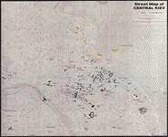 Street map of central Kiev.
Contributor:
United States. Central Intelligence Agency
Site:
American Memory-cultural, Main Catalog
Original Format:
Map
Date:
1979
View catalog record
Street map of central Kiev.
Contributor:
United States. Central Intelligence Agency
Site:
American Memory-cultural, Main Catalog
Original Format:
Map
Date:
1979
View catalog record
-
 Cartes du delta du Danube et plans comparatifs de l'embouchure et des sections fluviales du bras de Soulina indiquant les derniers travaux qui y ont ...
Contributor:
Commission européenne du Danube, Commission européenne du Danube
Site:
American Memory-cultural, Main Catalog
Original Format:
Map
Date:
1887
View catalog record
Cartes du delta du Danube et plans comparatifs de l'embouchure et des sections fluviales du bras de Soulina indiquant les derniers travaux qui y ont ...
Contributor:
Commission européenne du Danube, Commission européenne du Danube
Site:
American Memory-cultural, Main Catalog
Original Format:
Map
Date:
1887
View catalog record
-
 Town plan, Odessa.
Contributor:
United States. Central Intelligence Agency
Site:
American Memory-cultural, Main Catalog
Original Format:
Map
Date:
1962
View catalog record
Town plan, Odessa.
Contributor:
United States. Central Intelligence Agency
Site:
American Memory-cultural, Main Catalog
Original Format:
Map
Date:
1962
View catalog record
-
 Karta raĭonov Pinskago, Volynskikh ri︠e︡k i guzhevago dvizhenīi︠a︡ za Desnu /
Contributor:
Kartograficheskoe zavedenīe A. Ilʹina, Kartograficheskoe zavedenīe A. Ilʹina
Site:
American Memory-cultural, Main Catalog
Original Format:
Map
Date:
1870
View catalog record
Karta raĭonov Pinskago, Volynskikh ri︠e︡k i guzhevago dvizhenīi︠a︡ za Desnu /
Contributor:
Kartograficheskoe zavedenīe A. Ilʹina, Kartograficheskoe zavedenīe A. Ilʹina
Site:
American Memory-cultural, Main Catalog
Original Format:
Map
Date:
1870
View catalog record
You might also like
-

 Ukraine parliamentary elections : briefing of the Commission on Security and Cooperation in Europe.
Contributor:
United States. Congress. Commission on Security and Cooperation in Europe
Site:
Main Catalog
Original Format:
Book
Date:
2002
Ukraine parliamentary elections : briefing of the Commission on Security and Cooperation in Europe.
Contributor:
United States. Congress. Commission on Security and Cooperation in Europe
Site:
Main Catalog
Original Format:
Book
Date:
2002
-
Ukraïnsʹka Pontyda : heopolitychni vymiry suchasnoï Ukraïny /
Contributor:
Bahan, Oleh
Site:
Main Catalog
Original Format:
Book
Date:
2002
-
L'Ukraine, l'Europe orientale et la Conférence de la paix,
Contributor:
Kouchnire, M.
Site:
Main Catalog
Original Format:
Book
Date:
1919
-
The Jewish pogroms in Ukraine,
Contributor:
Bachynsʹkyĭ, I︠U︡lii︠a︡n
Site:
Main Catalog
Original Format:
Book
Date:
1919
-
Conditions in the Ukraine respecting treatment of Jews.
Contributor:
United States. Dept. of State
Site:
Main Catalog
Original Format:
Book
Date:
1920
-
Vid paradyhmy finansovoï stabilizat︠s︡iï do ideolohiï zrostanni︠a︡ : zbirnyk naukovykh stateĭ /
Contributor:
Kruhlyĭ stil "Bezpeka ekonomichnykh transformat︠s︡ii
Site:
Main Catalog
Original Format:
Book
Date:
2002