Map
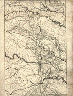
Route of the Tenth New York Cavalry from Culpeper to Gettysburg and return. Summer and fall campaigns of 1863.

| Format |
Map |
|---|---|
| Contributors |
Preston, Noble D. |
| Dates |
1863 |
| Location |
Pennsylvania United States Virginia |
| Language |
English |
| Subjects |
Civil War History Pennsylvania United States Virginia |
- Title
- Route of the Tenth New York Cavalry from Culpeper to Gettysburg and return. Summer and fall campaigns of 1863.
- Description
-
Scale ca. 1:440,000.
-
LC Civil War Maps (2nd ed.), 46
-
Finished pen and ink manuscript map of parts of Virginia, Maryland, and Pennsylvania, showing location and date of encampments and battles, route of the Tenth New York Cavalry, route of Capt. Pratt, roads, railroads, towns, drainage, and relief by hachures.
-
Printed version appears in Preston's History of the Tenth Regiment of Cavalry, New York State Volunteers, August, 1861, to August 1865. New York, D. Appleton, 1892. opp. p. 100.
-
Description derived from published bibliography.
-
Available also through the Library of Congress web site as raster image.
-
1 map ms. 39 x 25 cm.
- Creator
- Preston, Noble D.
- Created Published
-
[S.l.] 1863.
- Subject Headings
-
-
Virginia--History--Civil War, 1861-1865
-
-
Virginia
-
-
Pennsylvania--History--Civil War, 1861-1865
-
-
Pennsylvania
-
-
United States--Virginia.
-
-
United States--Pennsylvania.
- Notes
-
-
Scale ca. 1:440,000.
-
-
LC Civil War Maps (2nd ed.), 46
-
-
Finished pen and ink manuscript map of parts of Virginia, Maryland, and Pennsylvania, showing location and date of encampments and battles, route of the Tenth New York Cavalry, route of Capt. Pratt, roads, railroads, towns, drainage, and relief by hachures.
-
-
Printed version appears in Preston's History of the Tenth Regiment of Cavalry, New York State Volunteers, August, 1861, to August 1865. New York, D. Appleton, 1892. opp. p. 100.
-
-
Description derived from published bibliography.
-
-
Available also through the Library of Congress web site as raster image.
- Medium
-
1 map ms. 39 x 25 cm.
- Call Number
-
G3881.S5 1863 .P7
- Repository
-
Library of Congress Geography and Map Division Washington, D.C. 20540-4650 dcu
- Digital Id
-
g3881s cw0046000 http://hdl.loc.gov/loc.gmd/g3881s.cw0046000
- Library of Congress Catalog Number
- 99446355
Rights & Access
The maps in the Map Collections materials were either published prior to 1922, produced by the United States government, or both (see catalogue records that accompany each map for information regarding date of publication and source). The Library of Congress is providing access to these materials for educational and research purposes and is not aware of any U.S. copyright protection (see Title 17 of the United States Code) or any other restrictions in the Map Collection materials.
Note that the written permission of the copyright owners and/or other rights holders (such as publicity and/or privacy rights) is required for distribution, reproduction, or other use of protected items beyond that allowed by fair use or other statutory exemptions. Responsibility for making an independent legal assessment of an item and securing any necessary permissions ultimately rests with persons desiring to use the item.
More about Copyright and other Restrictions
For guidance about compiling full citations consult Citing Primary Sources.
Part of...
-
Civil War Maps
[2281]
-
Military Battles And Campaigns Cartographic Items
[3867]
-
Geography And Maps Division
[60803]
-
American Memory
[1121009]
More maps like this
-
 Map of a part of the eastern portion of Virginia showing the route of the Cavalry Corps of the Army of the Potomac under Major ...
Contributor:
Preston, Noble D.
Site:
American Memory-cultural, Main Catalog
Original Format:
Map
Date:
1907
View catalog record
Map of a part of the eastern portion of Virginia showing the route of the Cavalry Corps of the Army of the Potomac under Major ...
Contributor:
Preston, Noble D.
Site:
American Memory-cultural, Main Catalog
Original Format:
Map
Date:
1907
View catalog record
-
 Map of a part of the eastern portion of Virginia showing the route of the Cavalry Corps of the Army of the Potomac under Major ...
Contributor:
Preston, Noble D.
Site:
American Memory-cultural, Main Catalog
Original Format:
Map
Date:
1903
View catalog record
Map of a part of the eastern portion of Virginia showing the route of the Cavalry Corps of the Army of the Potomac under Major ...
Contributor:
Preston, Noble D.
Site:
American Memory-cultural, Main Catalog
Original Format:
Map
Date:
1903
View catalog record
-
 Map showing the positions occupied by the Tenth New York Cavalry in the cavalry engagements on the right flank at Gettysburg, Penn. : on July ...
Contributor:
Preston, Noble D.
Site:
American Memory-cultural, Main Catalog
Original Format:
Map
Date:
1863
View catalog record
Map showing the positions occupied by the Tenth New York Cavalry in the cavalry engagements on the right flank at Gettysburg, Penn. : on July ...
Contributor:
Preston, Noble D.
Site:
American Memory-cultural, Main Catalog
Original Format:
Map
Date:
1863
View catalog record
-
 Map [of] central Virginia showing the movements of the Tenth New York Cavalry in the campaigs [sic] of 1864.
Contributor:
Preston, Noble D.
Site:
American Memory-cultural, Main Catalog
Original Format:
Map
Date:
1892
View catalog record
Map [of] central Virginia showing the movements of the Tenth New York Cavalry in the campaigs [sic] of 1864.
Contributor:
Preston, Noble D.
Site:
American Memory-cultural, Main Catalog
Original Format:
Map
Date:
1892
View catalog record
-
 Map covering the field of operations of the Army of the Potomac
Contributor:
Preston, Noble D.
Site:
American Memory-cultural, Main Catalog
Original Format:
Map
Date:
1905
View catalog record
Map covering the field of operations of the Army of the Potomac
Contributor:
Preston, Noble D.
Site:
American Memory-cultural, Main Catalog
Original Format:
Map
Date:
1905
View catalog record
-
 From Dinwiddie C.H. to Appomattox C.H., route and operations of the 10th New York Cavalry.
Contributor:
Preston, Noble D.
Site:
American Memory-cultural, Main Catalog
Original Format:
Map
Date:
1892
View catalog record
From Dinwiddie C.H. to Appomattox C.H., route and operations of the 10th New York Cavalry.
Contributor:
Preston, Noble D.
Site:
American Memory-cultural, Main Catalog
Original Format:
Map
Date:
1892
View catalog record
-
 Map of the region between Gettysburg, Pa. and Appomattox court house, Va. : including all the battle-fields [sic] of the Army of Northern Virginia /
Contributor:
Michler, N.
Site:
American Memory-cultural, Main Catalog
Original Format:
Map
View catalog record
Map of the region between Gettysburg, Pa. and Appomattox court house, Va. : including all the battle-fields [sic] of the Army of Northern Virginia /
Contributor:
Michler, N.
Site:
American Memory-cultural, Main Catalog
Original Format:
Map
View catalog record
-
 Map of eastern Virginia, 1862 /
Contributor:
Nicholson, W. L.
Site:
American Memory-cultural
Original Format:
Map
Date:
1862
Map of eastern Virginia, 1862 /
Contributor:
Nicholson, W. L.
Site:
American Memory-cultural
Original Format:
Map
Date:
1862
-
 Map of eastern Virginia, 1862 /
Contributor:
Nicholson, W. L.
Site:
American Memory-cultural
Original Format:
Map
Date:
1862
Map of eastern Virginia, 1862 /
Contributor:
Nicholson, W. L.
Site:
American Memory-cultural
Original Format:
Map
Date:
1862
-
 Battle-field map showing field of operations of the Armies of the Potomac and James
Contributor:
Van Hook, J. C.
Site:
American Memory-cultural, Main Catalog
Original Format:
Map
Date:
1892
View catalog record
Battle-field map showing field of operations of the Armies of the Potomac and James
Contributor:
Van Hook, J. C.
Site:
American Memory-cultural, Main Catalog
Original Format:
Map
Date:
1892
View catalog record
-
 Bacon's topographical map of the seat of war in Virginia, Maryland and Pennsylvania
Contributor:
G.W. Bacon & Co
Site:
American Memory-cultural
Original Format:
Map
Date:
1863
Bacon's topographical map of the seat of war in Virginia, Maryland and Pennsylvania
Contributor:
G.W. Bacon & Co
Site:
American Memory-cultural
Original Format:
Map
Date:
1863
-
 [Maps illustrating the Gettysburg campaign. June 3-July 3, 1863].
Contributor:
Wells, Jacob
Site:
American Memory-cultural, Main Catalog
Original Format:
Map
Date:
1886-01-01
View catalog record
[Maps illustrating the Gettysburg campaign. June 3-July 3, 1863].
Contributor:
Wells, Jacob
Site:
American Memory-cultural, Main Catalog
Original Format:
Map
Date:
1886-01-01
View catalog record
-
 Map of Virginia and neighboring states showing the location of battles in the Civil War 1861-1865.
Contributor:
Northrup, William P.
Site:
American Memory-cultural, Main Catalog
Original Format:
Map
Date:
1912
View catalog record
Map of Virginia and neighboring states showing the location of battles in the Civil War 1861-1865.
Contributor:
Northrup, William P.
Site:
American Memory-cultural, Main Catalog
Original Format:
Map
Date:
1912
View catalog record
-
 Map of the seat of war /
Contributor:
Evans & Cogswell
Site:
American Memory-cultural, Main Catalog
Original Format:
Map
Date:
1861
View catalog record
Map of the seat of war /
Contributor:
Evans & Cogswell
Site:
American Memory-cultural, Main Catalog
Original Format:
Map
Date:
1861
View catalog record
-
 Johnson's Pennsylvania, Virginia, Delaware, and Maryland
Contributor:
Johnson & Browning
Site:
American Memory-cultural
Original Format:
Map
Date:
1862
Johnson's Pennsylvania, Virginia, Delaware, and Maryland
Contributor:
Johnson & Browning
Site:
American Memory-cultural
Original Format:
Map
Date:
1862
You might also like
-
 [Nine views of the Gettysburg battlefield from photographs by Mathew Brady and Army of the Potomac's Twelfth Corps crossing the Rappahannock River in pursuit of ...
Site:
Prints & Photographs, Main Catalog
Original Format:
Photo, Print, Drawing
Date:
1863
View catalog record
[Nine views of the Gettysburg battlefield from photographs by Mathew Brady and Army of the Potomac's Twelfth Corps crossing the Rappahannock River in pursuit of ...
Site:
Prints & Photographs, Main Catalog
Original Format:
Photo, Print, Drawing
Date:
1863
View catalog record
-

 The valley of the shadow two communities in the American Civil War.
Site:
Main Catalog
Original Format:
Book
Date:
2004
The valley of the shadow two communities in the American Civil War.
Site:
Main Catalog
Original Format:
Book
Date:
2004
-
Report of the Culpeper, Virginia, Monument Commission of Pennsylvania.
Contributor:
Pennsylvania. Culpeper, Virginia, Monument Commission
Site:
Main Catalog
Original Format:
Book
Date:
1914
-
-
-
