Map
Americae sive qvartae orbis partis nova et exactissima descriptio /

| Format |
Map |
|---|---|
| Contributors |
GutiéRrez, Diego GutiéRrez, Diego |
| Dates |
1562 |
| Location |
America Western Hemisphere |
| Language |
Latin |
| Subjects |
America Western Hemisphere |
- Title
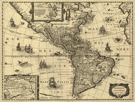
- Americae sive qvartae orbis partis nova et exactissima descriptio /
- Description
-
Covers North and South America with the adjacent seas.
-
Relief shown pictorially.
-
From the Rosenwald Collection, Library of Congress, no. 1303.
-
Originally printed on 6 sheets.
-
Described in Quarterly Journal of the Library of Congress, v. 6, no. 3 (May 1949), p. 18-20.
-
Includes texts in cartouche, statements of dedication, coats-of-arms, ill. of allegorical figure "Victoria", and ill. of sailing ships at sea and imaginary marine creatures.
-
Available also through the Library of Congress Web site as a raster image.
-
LC sheet trimmed.
-
1 map ; 83 x 86 cm., on sheet 100 x 102 cm.
- Creator
- Gutiérrez, Diego,
- Created Published
-
[Antwerp : s.n.], 1562.
- Subject Headings
-
-
Western Hemisphere
-
-
America
-
-
Western Hemisphere.
-
-
America.
- Notes
-
-
Covers North and South America with the adjacent seas.
-
-
Relief shown pictorially.
-
-
From the Rosenwald Collection, Library of Congress, no. 1303.
-
-
Originally printed on 6 sheets.
-
-
Described in Quarterly Journal of the Library of Congress, v. 6, no. 3 (May 1949), p. 18-20.
-
-
Includes texts in cartouche, statements of dedication, coats-of-arms, ill. of allegorical figure "Victoria", and ill. of sailing ships at sea and imaginary marine creatures.
-
-
Available also through the Library of Congress Web site as a raster image.
-
-
LC sheet trimmed.
- Medium
-
1 map ; 83 x 86 cm., on sheet 100 x 102 cm.
- Call Number
-
G3290 1562 .G7
- Repository
-
Library of Congress Geography and Map Division Washington, D.C. 20540-4650 USA dcu
- Digital Id
-
g3290 ct000342 http://hdl.loc.gov/loc.gmd/g3290.ct000342
- Library of Congress Catalog Number
- map49000970
Rights & Access
The maps in the Map Collections materials were either published prior to 1922, produced by the United States government, or both (see catalogue records that accompany each map for information regarding date of publication and source). The Library of Congress is providing access to these materials for educational and research purposes and is not aware of any U.S. copyright protection (see Title 17 of the United States Code) or any other restrictions in the Map Collection materials.
Note that the written permission of the copyright owners and/or other rights holders (such as publicity and/or privacy rights) is required for distribution, reproduction, or other use of protected items beyond that allowed by fair use or other statutory exemptions. Responsibility for making an independent legal assessment of an item and securing any necessary permissions ultimately rests with persons desiring to use the item.
More about Copyright and other Restrictions
For guidance about compiling full citations consult Citing Primary Sources.
Part of...
-
Discovery And Exploration
[150]
-
Mapping The National Parks
[170]
-
Additional Conservation And Environment Cartographic Items
[232]
-
Geography And Maps Division
[60803]
-
American Memory
[1121009]
More maps like this
-
 Americam utramque : aliis correctiorem /
Contributor:
Keulen, Gerard van
Site:
American Memory-cultural, Main Catalog
Original Format:
Map
Date:
1700
View catalog record
Americam utramque : aliis correctiorem /
Contributor:
Keulen, Gerard van
Site:
American Memory-cultural, Main Catalog
Original Format:
Map
Date:
1700
View catalog record
-
 America.
Contributor:
Arnoldi, Arnoldo di
Site:
American Memory-cultural, Main Catalog
Original Format:
Map
Date:
1600
View catalog record
America.
Contributor:
Arnoldi, Arnoldo di
Site:
American Memory-cultural, Main Catalog
Original Format:
Map
Date:
1600
View catalog record
-
 Cartes et plans de l'Amerique.
Site:
American Memory-cultural, Main Catalog
Original Format:
Map
Date:
1745
View catalog record
Cartes et plans de l'Amerique.
Site:
American Memory-cultural, Main Catalog
Original Format:
Map
Date:
1745
View catalog record
-
 Map of America by Diego Ribero 1529.
Contributor:
Kohl, J. G.
Site:
American Memory-cultural, Main Catalog
Original Format:
Map
Date:
1840
View catalog record
Map of America by Diego Ribero 1529.
Contributor:
Kohl, J. G.
Site:
American Memory-cultural, Main Catalog
Original Format:
Map
Date:
1840
View catalog record
-
 Carte d'Amerique dressée pour l'usage du Roy.
Contributor:
L'Isle, Guillaume de
Site:
American Memory-cultural, Main Catalog
Original Format:
Map
Date:
1780
View catalog record
Carte d'Amerique dressée pour l'usage du Roy.
Contributor:
L'Isle, Guillaume de
Site:
American Memory-cultural, Main Catalog
Original Format:
Map
Date:
1780
View catalog record
-
 Die neuwen Inseln, so hinder Hispanien gegen Orient bey dem land India ligen.
Contributor:
Münster, Sebastian, Münster, Sebastian
Site:
American Memory-cultural, Main Catalog
Original Format:
Map
Date:
1550
View catalog record
Die neuwen Inseln, so hinder Hispanien gegen Orient bey dem land India ligen.
Contributor:
Münster, Sebastian, Münster, Sebastian
Site:
American Memory-cultural, Main Catalog
Original Format:
Map
Date:
1550
View catalog record
-
 Amerikē /
Contributor:
Lazaridis, Her
Site:
American Memory-cultural, Main Catalog
Original Format:
Map
Date:
1860
View catalog record
Amerikē /
Contributor:
Lazaridis, Her
Site:
American Memory-cultural, Main Catalog
Original Format:
Map
Date:
1860
View catalog record
-
 Azimuthal equidistant projection centered on Bogotá, Colombia. 3-66.
Contributor:
United States. Central Intelligence Agency
Site:
American Memory-cultural, Main Catalog
Original Format:
Map
Date:
1966
View catalog record
Azimuthal equidistant projection centered on Bogotá, Colombia. 3-66.
Contributor:
United States. Central Intelligence Agency
Site:
American Memory-cultural, Main Catalog
Original Format:
Map
Date:
1966
View catalog record
-
 Nle. carte d'Amerique : dressée sur les mémoires les plus récens et assujetie aux derniers observations astronomiques /
Contributor:
Desnos, Louis-Charles
Site:
American Memory-cultural, Main Catalog
Original Format:
Map
Date:
1781
View catalog record
Nle. carte d'Amerique : dressée sur les mémoires les plus récens et assujetie aux derniers observations astronomiques /
Contributor:
Desnos, Louis-Charles
Site:
American Memory-cultural, Main Catalog
Original Format:
Map
Date:
1781
View catalog record
-
 L'Amerique, divisée en tous ses pays et etats : dressée sur de nouveaux mémoires et sur les derniers observations /
Contributor:
Longchamps, Sébastian G., Longchamps, Sébastian G.
Site:
American Memory-cultural, Main Catalog
Original Format:
Map
Date:
1754
View catalog record
L'Amerique, divisée en tous ses pays et etats : dressée sur de nouveaux mémoires et sur les derniers observations /
Contributor:
Longchamps, Sébastian G., Longchamps, Sébastian G.
Site:
American Memory-cultural, Main Catalog
Original Format:
Map
Date:
1754
View catalog record
-
 Maps of the world's nations.
Contributor:
United States. Central Intelligence Agency
Site:
American Memory-cultural, Main Catalog
Original Format:
Map
Date:
1976
View catalog record
Maps of the world's nations.
Contributor:
United States. Central Intelligence Agency
Site:
American Memory-cultural, Main Catalog
Original Format:
Map
Date:
1976
View catalog record
-
 America noviter delineata /
Contributor:
Hondius, Jodocus
Site:
American Memory-cultural, Main Catalog
Original Format:
Map
Date:
1640
View catalog record
America noviter delineata /
Contributor:
Hondius, Jodocus
Site:
American Memory-cultural, Main Catalog
Original Format:
Map
Date:
1640
View catalog record
-
 Nova totivs Americæ descriptio.
Contributor:
Wit, Frederick de
Site:
American Memory-cultural, Main Catalog
Original Format:
Map
Date:
1660
View catalog record
Nova totivs Americæ descriptio.
Contributor:
Wit, Frederick de
Site:
American Memory-cultural, Main Catalog
Original Format:
Map
Date:
1660
View catalog record
-
 Amerika, ěst nor ashkharhagrakan znnutʻeantsʻ : pʻoragreal i Vēnētik i Vans Srboyn Ghazaru i tʻuis merum 1236, 1787.
Contributor:
Endasian, Elia
Site:
American Memory-cultural, Main Catalog
Original Format:
Map
Date:
1787
View catalog record
Amerika, ěst nor ashkharhagrakan znnutʻeantsʻ : pʻoragreal i Vēnētik i Vans Srboyn Ghazaru i tʻuis merum 1236, 1787.
Contributor:
Endasian, Elia
Site:
American Memory-cultural, Main Catalog
Original Format:
Map
Date:
1787
View catalog record
-
 North and South America.
Contributor:
United States. Central Intelligence Agency
Site:
American Memory-cultural, Main Catalog
Original Format:
Map
Date:
1996
View catalog record
North and South America.
Contributor:
United States. Central Intelligence Agency
Site:
American Memory-cultural, Main Catalog
Original Format:
Map
Date:
1996
View catalog record
-
 [Map and views illustrating Sir Francis Drake's West Indian voyage, 1585-6].
Contributor:
Boazio, Baptista
Site:
American Memory-cultural, Main Catalog
Original Format:
Map
Date:
1589
View catalog record
[Map and views illustrating Sir Francis Drake's West Indian voyage, 1585-6].
Contributor:
Boazio, Baptista
Site:
American Memory-cultural, Main Catalog
Original Format:
Map
Date:
1589
View catalog record
You might also like
-
 Historia general de los hechos de los castellanos en las Islas i Tierra Firme del Mar Oceano,
Contributor:
Herrera y Tordesillas, Antonio de
Site:
American Memory-cultural, Main Catalog
Original Format:
Book
Date:
1601
View catalog record
Historia general de los hechos de los castellanos en las Islas i Tierra Firme del Mar Oceano,
Contributor:
Herrera y Tordesillas, Antonio de
Site:
American Memory-cultural, Main Catalog
Original Format:
Book
Date:
1601
View catalog record
-
 To authorize the establishment of a social investment and economic development fund for the Americas, etc. : markup before the Subcommittee on the Western Hemisphere ...
Contributor:
United States. Congress. House. Committee on International Relations. Subcommittee on the Western Hemisphere
Site:
Main Catalog
Original Format:
Book
Date:
2004-05-05
To authorize the establishment of a social investment and economic development fund for the Americas, etc. : markup before the Subcommittee on the Western Hemisphere ...
Contributor:
United States. Congress. House. Committee on International Relations. Subcommittee on the Western Hemisphere
Site:
Main Catalog
Original Format:
Book
Date:
2004-05-05
-
A treatise on the Western Hemisphere Caraboidea (Coleoptera) their classification, distributions, and ways of life /
Contributor:
Erwin, Terry L.
Site:
Main Catalog
Original Format:
Book
Date:
2007
-
 H.R.1014 - A bill to amend the Immigration and Nationality Act to increase immigration from Western Hemisphere nations.
Contributor:
Roybal, Edward R.
Site:
Thomas-legislative
Original Format:
Legislation
Date:
1975-01-14
H.R.1014 - A bill to amend the Immigration and Nationality Act to increase immigration from Western Hemisphere nations.
Contributor:
Roybal, Edward R.
Site:
Thomas-legislative
Original Format:
Legislation
Date:
1975-01-14
-
Western Hemisphere energy security : hearing before the Subcommittee on the Western Hemisphere of the Committee on International Relations, House of Representatives, One Hundred Ninth ...
Contributor:
United States. Congress. House. Committee on International Relations. Subcommittee on the Western Hemisphere
Site:
Main Catalog
Original Format:
Book
Date:
2006-03-02
-
H.R.7116 - American Foreign Affairs Western Hemispheric Act
Contributor:
Waggoner, Joe D., Jr
Site:
Thomas-legislative
Original Format:
Legislation
Date:
1973-04-17