Title: The Oztoticpac Lands Map
Description
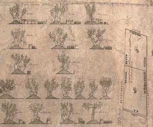
- Dated at approximately 1540, this map, a Mexican pictorial document with writing in Spanish and Nahuatl, relates to a lawsuit concerning the estate of Don Carlos Ometochtli Chichimecatecotl, an Aztec lord and one of the many sons of Nezahualpilli, ruler of Texcoco. Don Carlos was charged with heresy and publicly executed by the Spanish authorities on November 30, 1539. Litigation began on December 31, 1540, when a man identified as Pedro de Vergara petitioned the Inquisition to return to him certain fruit trees taken from the property of Don Carlos that Vergara claimed were his under a contract that had been concluded with Don Carlos several years earlier. Other individuals contended that the lands occupied by Don Carlos did not belong to him personally but to the family—the lords of Texcoco—as a whole. This map most likely was commissioned by Antonio Pimentel Tlahuilotzin, governor of Texcoco, to buttress these claims. Further complicating the case were claims by another set of petitioners that the Texcocan lands had been partitioned by the Spanish authorities and that lands held by Don Carlos during his lifetime were now the property of commoners. The outcome of the litigation is not known. The map reflects the pre-European, Mesoamerican tradition of using glyphs and indigenously produced paper (amatl) to make maps. Drawings done with red and black inks indicate land plots with indigenous measurements and place glyphs. Near the upper left is a plan of several houses within a precinct; on the right are maps showing more than 75 identified plots, an inventory of landed properties once owned by Don Carlos. In the lower left is a gloss of European fruit trees and grape vines grafted onto indigenous tree stock, the only such image of this agricultural technique known to exist in any Mexican indigenous pictorial document. The map provides details about the grafting of peach, apricot, pear, and other fruit trees imported from Spain onto apple and cherry trees indigenous to Mexico.
Language
Place
Time
Topic
Additional Subjects
Type of Item
Physical Description
- 1 map : manuscript, colored ; 76 x 84 centimeters
Notes
- Title derived from The Quarterly Journal of the Library of Congress, "The Oztoticpac Lands Map of Texcoco 1540," v. 23, no. 2, April 1966, pp. 76-116.
Institution
External Resource
