Title: General Map Showing the Explorations and Surveys of the Expedition, 1907-09
Description
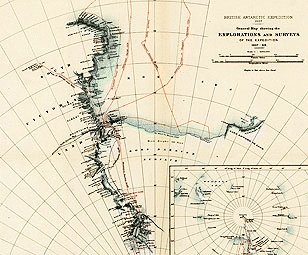
- The British Antarctica Expedition of 1907-09, led by Ernest H. Shackleton, left Port Lyttelton, New Zealand, in the ship Nimrod on January 1, 1908. On February 3, the Nimrod deposited Shackelton and a party of 14 men at Cape Royds. The men divided into three groups. One would try to reach the South Pole, a second went north to reach the South Magnetic Pole, while a third was to explore the mountains west of McMurdo Sound. Shackleton, three companions, and four ponies set out for the South Pole on October 29. Enduring great hardship, on January 9, 1909, they attained a latitude of 88°23’ S., further south than any previous expedition. There they were forced to turn back by fierce blizzards and low supplies. This map, from a 1909 article by Shackelton, traces the route of the three exploring parties and of the Nimrod, on which the men returned safely to New Zealand. The expedition made important scientific discoveries in geology, biology, and other fields. Some three years later, on December 14, 1911, the Norwegian Roald Amundsen and four companions finally reached the pole.
Author
Publication Information
-
Royal Geographical Society, England
Language
Place
Time
Topic
Additional Subjects
Type of Item
Physical Description
- 1 color map ; 39 x 39 centimeters
Notes
Institution
External Resource
