Title: Map of Georgia and Alabama
Description
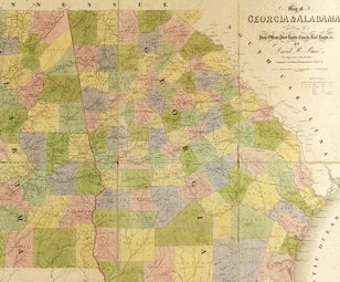
- David H. Burr (1803–75) was a surveyor and cartographer, who served as topographer to the United States Post Office Department in 1832–38 and as geographer to the House of Representatives in 1838–47. Under the direction of the postmaster general, Burr compiled information from postmasters throughout the country about transportation routes—post roads, railroads, and canals—and the location of post offices to produce a large set of state and regional maps. Published in 1839 by the prominent London mapmaking firm of John Arrowsmith, Burr’s The American Atlas offers a detailed picture of settlement and transportation patterns in the United States in the decades before the Civil War. Shown here is Burr’s map of Georgia and Alabama, one of 13 maps in the atlas. Georgia was the southernmost of the 13 colonies to form the United States. Alabama was acquired by the United States from Spain in 1810 and was admitted to the Union in 1819 as the 22nd state. Both states were very rural, with economies heavily based on large cotton plantations. By the time of Burr’s map, the enslaved Africans who worked these plantations accounted for between 35 and 45 percent of the population of each state.
Cartographer
Publication Information
Language
Place
Time
Topic
Additional Subjects
Type of Item
Physical Description
- 1 map from loose-leaf atlas : hand colored, mounted on cloth ; 130 x 130 centimeters or smaller, folded in case 50 x 33 x 7 centimeters
Institution
