- slusevokterboligen - nilsenhelgeir
- slusemesterboligen - nilsenhelgeir
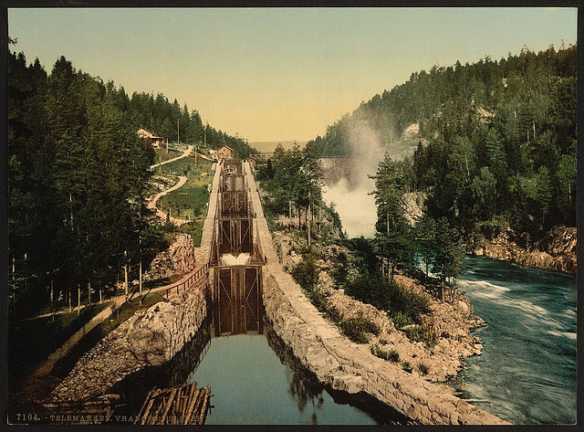
[Vuangfos Lock, Bandak Canal, Telemarken (i.e, Telemark), Norway] (LOC)
[Vuangfos Lock, Bandak Canal, Telemarken (i.e, Telemark), Norway]
[between ca. 1890 and ca. 1900].
1 photomechanical print : photochrom, color.
Notes:
Title from the Detroit Publishing Co., Catalogue J--foreign section.
Detroit, Mich. : Detroit Publishing Company, 1905.
Print no. 7104.
Forms part of: Landscape and marine views of Norway in the Photochrom
print collection.
Subjects:
Norway--Telemark fylke.
Format: Photochrom prints--Color--1890-1900.
Rights Info: No known restrictions on publication.
Repository: Library of Congress, Prints and Photographs Division, Washington, D.C. 20540 USA, hdl.loc.gov/loc.pnp/pp.print
Part Of: Landscape and marine views of Norway (DLC) 2001699563
More information about the Photochrom Print Collection is available athdl.loc.gov/loc.pnp/pp.pgz
Persistent URL: hdl.loc.gov/loc.pnp/ppmsc.06242
Call Number: LOT 13432, no. 140 [item]
![[Hotel Dalen, Telemarken (i.e, Telemark), Norway] (LOC)](https://cybercemetery.unt.edu/archive/oilspill/20121116055826im_/http://farm2.staticflickr.com/1084/3174204429_6d4eddbb0d_s.jpg)
![[Dalen, Telemarken (i.e, Telemark), Norway] (LOC)](https://cybercemetery.unt.edu/archive/oilspill/20121116055826im_/http://farm2.staticflickr.com/1012/3175040364_7eef7d257f_s.jpg)
![[Vuangfos Lock, Bandak Canal, Telemarken (i.e, Telemark), Norway] (LOC)](https://cybercemetery.unt.edu/archive/oilspill/20121116055826im_/http://farm4.staticflickr.com/3119/3175040164_3b182699fc_s.jpg)
![[Loveid Lock, Telemarken (i.e, Telemark), Norway] (LOC)](https://cybercemetery.unt.edu/archive/oilspill/20121116055826im_/http://farm2.staticflickr.com/1124/3174203755_9e927aa807_s.jpg)
![[Bandak Lake from Dalen, Telemarken (i.e, Telemark), Norway] (LOC)](https://cybercemetery.unt.edu/archive/oilspill/20121116055826im_/http://farm4.staticflickr.com/3106/3175039800_4608bd8120_s.jpg)
Comments and faves
AustinChernich, sakraft1, ˙ʞ ʎlǝ, HeadOvMetal, and 40 other people added this photo to their favorites.
sakraft1 (47 months ago | reply)
That's quite a canal!
StianH (47 months ago | reply)
Title should be Vrangfos Lock, not Vuangfos. Nowadays Vrangfoss (litt. "difficult waterfall").
The Steam Tavern [deleted] (47 months ago | reply)
Also, the canal is nowadays called "Telemarkskanalen", i. e. Telemark Canal. It goes all the way from Dalen to the sea (Skagerrak), with a side-arm stretching north to Notodden. Just great for canoeing and camping!
nilsenhelgeir (47 months ago | reply)
Vrangfoss is the correct name. It is also a regrettable fact that nowadays
tourist agencies use the collective name Telemarkskanalen for two canalizing projects with different history, but linked by the Norsjø lake:
Bandakkanalen (or Norsjø-Bandakkanalen) and Skien-Norsjøkanalen
Vrangfoss is the highest waterfall on the Bandak canal / Bandakkanalen
Central area of the picture is position 6573658 N, 511558 E.. UTMV32
General axis of view about straight NW , probably shot from
a small elevation beside the old tourist pathway between Eidsfoss and Vrangfoss: Kongens utsikt (The King's view, don't actually know
wether the union king of Norway and Sweden actually ever stood there, but he visited the canal a year after the opening ceremony)
at position 6573512 N, 511702 E. UTMV32
liltiffanyu (40 months ago | reply)
This looks like a very simple but elegant canal. It doesn't look like it's cluttering the area like most seem to do.