Map
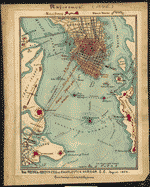
Map of siege of Fort Pulaski : Savannah River Georgia. 1862.

| Format |
Map |
|---|---|
| Contributors |
Sneden, Robert Knox |
| Dates |
1862 |
| Location |
Fort Pulaski Georgia Savannah River South Carolina United States |
| Language |
English |
| Subjects |
Civil War Fort Pulaski Fort Pulaski (Ga.) Georgia History Savannah River Savannah River (Ga. And S.C.) Siege United States |
- Title
- Map of siege of Fort Pulaski : Savannah River Georgia. 1862.
- Description
-
Color coding indicates the location of Union and Confederate forces.
-
NOTE: Researchers will be served a color photocopy of this diary image.
-
Relief shown by hachures.
-
This item is from the collections of the Virginia Historical Society; please contact the institution for more information.
-
Shows the location of Jones Island, Turtle Island and Daufuskie Island on the north edge of the Savannah River and Querns Island, Wilmington Island and Big Tybee Island to the south, also indicated is the location of Fort Pulaski on Cockspur Island in the middle of the Savannah River.
-
Available also through the Library of Congress web site as a raster image.
-
Robert Knox Sneden Scrapbook (Mss5:7 Sn237:1), Virginia Historical Society, Richmond, Va.
-
In the Robert Knox Sneden Diary (Mss5:1 Sn237:1 v. 1, p. 824).
-
Manuscripts
-
1 map : pen-and-ink and watercolor ; 16 x 11 cm.
- Creator
- Sneden, Robert Knox, 1832-1918.
- Created Published
-
[1862-1865].
- Subject Headings
-
-
Fort Pulaski (Ga.)--History--Siege, 1862
-
-
Savannah River (Ga. and S.C.)--History--Civil War, 1861-1865
-
-
United States--Georgia--Savannah River.
-
-
United States--Georgia--Fort Pulaski.
- Notes
-
-
Color coding indicates the location of Union and Confederate forces.
-
-
NOTE: Researchers will be served a color photocopy of this diary image.
-
-
Relief shown by hachures.
-
-
This item is from the collections of the Virginia Historical Society; please contact the institution for more information.
-
-
Shows the location of Jones Island, Turtle Island and Daufuskie Island on the north edge of the Savannah River and Querns Island, Wilmington Island and Big Tybee Island to the south, also indicated is the location of Fort Pulaski on Cockspur Island in the middle of the Savannah River.
-
-
Available also through the Library of Congress web site as a raster image.
-
-
Robert Knox Sneden Scrapbook (Mss5:7 Sn237:1), Virginia Historical Society, Richmond, Va.
-
-
In the Robert Knox Sneden Diary (Mss5:1 Sn237:1 v. 1, p. 824).
-
-
Manuscripts
- Medium
-
1 map : pen-and-ink and watercolor ; 16 x 11 cm.
- Repository
-
Virginia Historical Society, P.O. Box 7311, Richmond, VA 23221-0311 USA vau
- Digital Id
-
gvhs01 vhs00085 http://hdl.loc.gov/loc.ndlpcoop/gvhs01.vhs00085
Rights & Access
The maps in the Map Collections materials were either published prior to 1922, produced by the United States government, or both (see catalogue records that accompany each map for information regarding date of publication and source). The Library of Congress is providing access to these materials for educational and research purposes and is not aware of any U.S. copyright protection (see Title 17 of the United States Code) or any other restrictions in the Map Collection materials.
Note that the written permission of the copyright owners and/or other rights holders (such as publicity and/or privacy rights) is required for distribution, reproduction, or other use of protected items beyond that allowed by fair use or other statutory exemptions. Responsibility for making an independent legal assessment of an item and securing any necessary permissions ultimately rests with persons desiring to use the item.
More about Copyright and other Restrictions
For guidance about compiling full citations consult Citing Primary Sources.
Part of...
-
Civil War Maps
[2281]
-
Military Battles And Campaigns Cartographic Items
[3867]
-
Geography And Maps Division
[60803]
-
American Memory
[1121009]
More maps like this
-
 Attack on Ft. Pulaski Savannah, Georgia, April 1862.
Contributor:
Sneden, Robert Knox
Site:
American Memory-cultural
Original Format:
Map
Date:
1862
Attack on Ft. Pulaski Savannah, Georgia, April 1862.
Contributor:
Sneden, Robert Knox
Site:
American Memory-cultural
Original Format:
Map
Date:
1862
-
 Copy of official plan of the siege of Fort Pulaski. Cockspur Island. Savannah Georgia April 1862 : by Union forces under Genl Gillmore and Hunter.
Contributor:
Sneden, Robert Knox
Site:
American Memory-cultural
Original Format:
Map
Date:
1862
Copy of official plan of the siege of Fort Pulaski. Cockspur Island. Savannah Georgia April 1862 : by Union forces under Genl Gillmore and Hunter.
Contributor:
Sneden, Robert Knox
Site:
American Memory-cultural
Original Format:
Map
Date:
1862
-
 The Rebel defences [sic] of Savannah, Georgia, Nov. 1864.
Contributor:
Sneden, Robert Knox
Site:
American Memory-cultural
Original Format:
Map
Date:
1861
The Rebel defences [sic] of Savannah, Georgia, Nov. 1864.
Contributor:
Sneden, Robert Knox
Site:
American Memory-cultural
Original Format:
Map
Date:
1861
-
 Map of the siege and investment of Savannah, Georgia, 5th to 20th Decr. 1864.
Contributor:
Sneden, Robert Knox
Site:
American Memory-cultural
Original Format:
Map
Date:
1861
Map of the siege and investment of Savannah, Georgia, 5th to 20th Decr. 1864.
Contributor:
Sneden, Robert Knox
Site:
American Memory-cultural
Original Format:
Map
Date:
1861
-
 A map of Savannah River beginning at Stone-Bluff, or Nexttobethell, which continueth to the sea; also, the four sounds Savañah, [Warsaw], Hossabaw, and St. Katharines, ...
Contributor:
De Brahm, John Gerar William
Site:
American Memory-cultural, Main Catalog
Original Format:
Map
Date:
1752
View catalog record
A map of Savannah River beginning at Stone-Bluff, or Nexttobethell, which continueth to the sea; also, the four sounds Savañah, [Warsaw], Hossabaw, and St. Katharines, ...
Contributor:
De Brahm, John Gerar William
Site:
American Memory-cultural, Main Catalog
Original Format:
Map
Date:
1752
View catalog record
-
 [Savannah River & Ogeechee River].
Site:
American Memory-cultural, Main Catalog
Original Format:
Map
Date:
1780
View catalog record
[Savannah River & Ogeechee River].
Site:
American Memory-cultural, Main Catalog
Original Format:
Map
Date:
1780
View catalog record
-
 A plan of the inlets & rivers of Savannah & Warsaw in the Province of Georgia.
Contributor:
Yonge, Henry
Site:
American Memory-cultural, Main Catalog
Original Format:
Map
Date:
1751
View catalog record
A plan of the inlets & rivers of Savannah & Warsaw in the Province of Georgia.
Contributor:
Yonge, Henry
Site:
American Memory-cultural, Main Catalog
Original Format:
Map
Date:
1751
View catalog record
-
 Map showing the investment and siege of Savannah, Georgia by Genl Sherman's army Decr 1864.
Contributor:
Sneden, Robert Knox
Site:
American Memory-cultural
Original Format:
Map
Date:
1861
Map showing the investment and siege of Savannah, Georgia by Genl Sherman's army Decr 1864.
Contributor:
Sneden, Robert Knox
Site:
American Memory-cultural
Original Format:
Map
Date:
1861
-
 The Rebel defences of Charleston Harbor S.C., August 1863
Contributor:
Sneden, Robert Knox
Site:
American Memory-cultural
Original Format:
Map
Date:
1861
The Rebel defences of Charleston Harbor S.C., August 1863
Contributor:
Sneden, Robert Knox
Site:
American Memory-cultural
Original Format:
Map
Date:
1861
-
 Charleston Harbor S.C. Bombardment of Fort Sumter.
Contributor:
Sneden, Robert Knox
Site:
American Memory-cultural
Original Format:
Map
Date:
1861
Charleston Harbor S.C. Bombardment of Fort Sumter.
Contributor:
Sneden, Robert Knox
Site:
American Memory-cultural
Original Format:
Map
Date:
1861
-
 Map showing route taken by U.S. prisoners of war, Feby. 1864, when sent from Richmond, Va., to Andersonville, Georgia.
Contributor:
Sneden, Robert Knox
Site:
American Memory-cultural
Original Format:
Map
Date:
1861
Map showing route taken by U.S. prisoners of war, Feby. 1864, when sent from Richmond, Va., to Andersonville, Georgia.
Contributor:
Sneden, Robert Knox
Site:
American Memory-cultural
Original Format:
Map
Date:
1861
-
 [Map of South Carolina, Georgia, Alabama, and Tennessee.]
Contributor:
Sneden, Robert Knox
Site:
American Memory-cultural
Original Format:
Map
Date:
1861
[Map of South Carolina, Georgia, Alabama, and Tennessee.]
Contributor:
Sneden, Robert Knox
Site:
American Memory-cultural
Original Format:
Map
Date:
1861
-
 The Defences [sic] of Savannah, Georgia, November 1864.
Contributor:
Sneden, Robert Knox
Site:
American Memory-cultural
Original Format:
Map
Date:
1864
The Defences [sic] of Savannah, Georgia, November 1864.
Contributor:
Sneden, Robert Knox
Site:
American Memory-cultural
Original Format:
Map
Date:
1864
-
 Plan of the Rebel prison pen at Savannah Georgia, Lt. S. R. Davis, C.S.A., Commandant, Sept. 1864.
Contributor:
Sneden, Robert Knox
Site:
American Memory-cultural
Original Format:
Map
Date:
1861
Plan of the Rebel prison pen at Savannah Georgia, Lt. S. R. Davis, C.S.A., Commandant, Sept. 1864.
Contributor:
Sneden, Robert Knox
Site:
American Memory-cultural
Original Format:
Map
Date:
1861
-
 Map made at Andersonville Prison [Sept. 1864].
Contributor:
Sneden, Robert Knox
Site:
American Memory-cultural
Original Format:
Map
Date:
1861
Map made at Andersonville Prison [Sept. 1864].
Contributor:
Sneden, Robert Knox
Site:
American Memory-cultural
Original Format:
Map
Date:
1861
-
 Plan of Andersonville Prison, Georgia. Aug. 1864.
Contributor:
Sneden, Robert Knox
Site:
American Memory-cultural
Original Format:
Map
Date:
1861
Plan of Andersonville Prison, Georgia. Aug. 1864.
Contributor:
Sneden, Robert Knox
Site:
American Memory-cultural
Original Format:
Map
Date:
1861
You might also like
-

 The rebel fleet of flag of truce boats in the Savannah River going down to the Leary & Hermann Livingstone to take off rebel prisoners
Contributor:
Waud, Alfred R.
Site:
Main Catalog
Original Format:
Photo, Print, Drawing
Date:
1862
The rebel fleet of flag of truce boats in the Savannah River going down to the Leary & Hermann Livingstone to take off rebel prisoners
Contributor:
Waud, Alfred R.
Site:
Main Catalog
Original Format:
Photo, Print, Drawing
Date:
1862
-
 Bombardment and surrender of Fort Pulaski
Contributor:
Grobe, Charles, Composer
Site:
Performing Arts Encyclopedia
Original Format:
Music Score
Date:
1862
Bombardment and surrender of Fort Pulaski
Contributor:
Grobe, Charles, Composer
Site:
Performing Arts Encyclopedia
Original Format:
Music Score
Date:
1862
-
 Col. Hall's grand march
Contributor:
Jarvis, Charles H., Composer
Site:
Performing Arts Encyclopedia
Original Format:
Music Score
Date:
1862
Col. Hall's grand march
Contributor:
Jarvis, Charles H., Composer
Site:
Performing Arts Encyclopedia
Original Format:
Music Score
Date:
1862
-
 Official report to the United States Engineer Department, of the siege and reduction of Fort Pulaski, Georgia, February, March, and April, 1862 /
Contributor:
Gillmore, Quincy Adams
Site:
Main Catalog
Original Format:
Book
Date:
1862
Official report to the United States Engineer Department, of the siege and reduction of Fort Pulaski, Georgia, February, March, and April, 1862 /
Contributor:
Gillmore, Quincy Adams
Site:
Main Catalog
Original Format:
Book
Date:
1862
-
 Fort Pulaski battle scars, Savannah, Ga.
Contributor:
Detroit Publishing Co
Site:
Prints & Photographs
Original Format:
Photo, Print, Drawing
Date:
1900
Fort Pulaski battle scars, Savannah, Ga.
Contributor:
Detroit Publishing Co
Site:
Prints & Photographs
Original Format:
Photo, Print, Drawing
Date:
1900
-
 Battery schottisch
Contributor:
Bechter, Hermann, Composer
Site:
Performing Arts Encyclopedia
Original Format:
Music Score
Date:
1863
Battery schottisch
Contributor:
Bechter, Hermann, Composer
Site:
Performing Arts Encyclopedia
Original Format:
Music Score
Date:
1863