skip navigation link

Earthquake Intensity Database Search
1638-1985

USA Intensity 
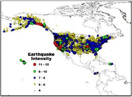
The Earthquake Intensity Database is a collection of damage and felt reports for over 23,000 U.S. earthquakes.
The digital database contains information regarding epicentral coordinates, magnitudes, focal depths, names and coordinates of reporting cities (or localities), reported intensities, and the distance from city (or locality) to epicenter. Earthquakes listed in the file date from 1638 to 1985.

Use this form to search the Earthquake Intensity Database. Please enter the information for one or more of the following search options and then click the Search Database button. Click the Clear Form button for each additional search. If you wish to retrieve the entire database, go to the bottom of this page and click the Clear Form button and the Search Database button.
The database contains over 157,015 events and is approximately 14 MB.
The Earthquake Intensity Database (1638-1985) includes the maximum intensity for each city (or locality) that felt a particular earthquake. For later years, the USGS National Earthquake Information Center provides maximum intensities for each event.
Note: These data are also available on a two-volume CD collection of seismicity catalogs containing data for more than four million earthquakes from 2100 B.C. to 1995 A.D.

Please review the Introduction for more information on the contents of this database.

Earthquake Parameters

Enter the Event Date as a year:
Beginning date (1638 to 1985): Ending date (1638 to 1985):

Enter the Epicenter Coordinates in decimal degrees:
Latitude: 4 to 69 (Northern Hemisphere--there are no events in the Southern hemisphere in this database)
Longitude: -179 to 56 (Western Hemisphere) or 120 to 180 (Eastern Hemisphere)
Northernmost Latitude (4 to 69)):
Westernmost Longitude (-179 to 180):
Easternmost Longitude (-179 to 180):
Southernmost Latitude (4 to 69)):
Note: About 25 percent of the 2,500 earthquakes reported from 1638-1928 and 10 percent of the 18,500 events from 1928-80 do not have instrumental epicenters, this omission is mainly due to the fact that seismological instruments were not developed until the late 1800s, and further, that the instruments were not widely distributed for many years later. Therefore, to retrieve all the events from a particular state, province, or country, leave the Epicenter Coordinates search parameters blank and select from the list of state names below.

Enter a range of Earthquake Magnitudes (0.0 to 9.9):
Minimum Magnitude: Maximum Magnitude:

Enter a range of Focal Depths (0 to 600 km):
Minimum Depth: Maximum Depth:

City and State Parameters


Enter the Modified Mercalli Intensity of a city (0 to 12):
Minimum Intensity: Maximum Intensity:

Select a State:

Enter a City Name:
(You may enter part of a name, and all names containing that string will be returned.)
Enter the City Coordinates in decimal degrees:
Latitude: 4 to 72 (Northern Hemisphere--there are no cities in the Southern Hemisphere in this database)
Longitude: -179 to -56 (Western Hemisphere) or 120 to 180 (Eastern Hemisphere)
Northernmost Latitude (4 to 72)):
Westernmost Longitude (-179 to 180):
Easternmost Longitude (-179 to 180):
Southernmost Latitude (4 to 72)):
Note: Several of the reporting cities have not been assigned geographic coordinates, therefore, to retrieve all the events for a particular city, leave the city coordinates search parameter blank and enter the City Name in the box above.

Enter a range of Epicentral Distances (0 to 10000 km):
Minimum Distance: Maximum Distance: