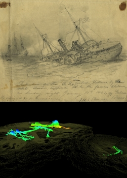
A new, 3-D state-of-the-art sonar map released January 11 by NOAA’s Office of National Marine Sanctuaries, ExploreOcean, Teledyne Blueview, and Northwest Hydro shows never-before-seen details of the USS Hatteras, the only Union warship sunk in combat in the Gulf of Mexico during the Civil War.
One hundred and fifty years ago this month, approximately 20 miles off the coast of Galveston, Texas, the Hatteras, an iron-hulled steamship the U.S. Navy converted into a gunboat, was sunk during a battle with the famous Confederate commerce raider CSS Alabama. The battle was one of the skirmishes that saw the key southern port of Galveston change hands twice and remain one of the last bastions of the Confederacy.
Today, the wreck of the Hatteras is largely intact, resting 57 feet underwater in sand and silt. Recent hurricanes and storms have removed some of the sediment and sand that once encased the vessel like a time capsule. Given shifting sands may once again rebury the Hatteras, the team used a short window of opportunity for a two-day mission last fall to create 3-D photo mosaics of the Hatteras for research, education, and outreach purposes. Read more | Photo gallery


Post new comment