Our Earth, at night
Suomi NPP satellite offers new, unprecedented views of our planet in amazing detail

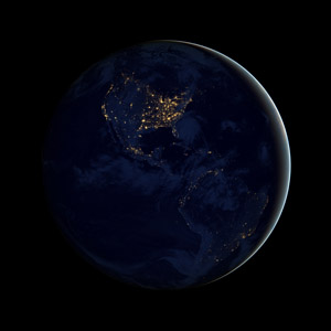
This new image of the Earth at night (showing the Americas) is a composite assembled from data acquired by the Suomi National Polar-orbiting Partnership (Suomi NPP) satellite over nine days in April 2012 and thirteen days in October 2012. It took 312 orbits and 2.5 terabytes of data to get a clear shot of every parcel of Earth’s land surface and islands. The nighttime view was made possible by the new satellite’s “day-night band” of the Visible Infrared Imaging Radiometer Suite. VIIRS detects light in a range of wavelengths from green to near-infrared and uses filtering techniques to observe dim signals such as city lights, gas flares, auroras, wildfires, and reflected moonlight. In this case, auroras, fires, and other stray light have been removed to emphasize the city lights.
Photo: NASA Earth Observatory image by Robert Simmon, using Suomi NPP VIIRS data provided courtesy of Chris Elvidge, NOAA National Geophysical Data Center. Suomi NPP is the result of a partnership between NOAA, NASA, and the Department of Defense. Find this image and others at http://earthobservatory.nasa.gov/NightLights.
How does the globe look when the sun goes down? Scientists today unveiled unprecedented snapshots of Earth at night. Global composite images, constructed from cloud-free nighttime images from the new NOAA-NASA Suomi NPP satellite, were showcased at the American Geophysical Union’s annual meeting in San Francisco. The images reveal the glow of human and natural phenomena across the entire Earth in more detail than ever before.
Many of today’s satellites are equipped to look at Earth during the day, when they can observe relatively bright objects ─ especially those illuminated by the sun. But the “day-night band” of the Visible Infrared Imaging Radiometer Suite (VIIRS) instrument on the Suomi NPP satellite is equipped with advanced technology that extends the view of Earth's atmosphere and surface into the nighttime hours.
In the new images, the first things to capture the eye are the planet’s cities.
“Nothing tells us more about the spread of humans across the Earth than city lights,” said NOAA’s Chris Elvidge. Elvidge has studied nighttime lights data since 1992, with satellite images far less precise than the news ones. “Even after 20 years, I'm always amazed at what city light images show us about human activity.”
Unlike a camera that captures a picture in one exposure, the day-night band produces an image by repeatedly scanning a scene and resolving it as millions of individual picture elements or pixels. The day-night band goes further, however, to ensure that each pixel collects the right amount of light. If a pixel is very bright, a low-gain mode prevents the pixel from oversaturating. If the pixel is very dark, the signal will be strongly amplified.

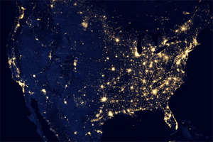
This image of the United States of America at night is a composite assembled from data acquired by the Suomi NPP satellite in April and October 2012. The image was made possible by the new satellite’s “day-night band” of the Visible Infrared Imaging Radiometer Suite (VIIRS), which detects light in a range of wavelengths from green to near-infrared and can observe dim signals such as city lights, gas flares, auroras, wildfires, and reflected moonlight.
Photo: NASA Earth Observatory image by Jesse Allen and Robert Simmon, using VIIRS day-night band data from the Suomi National Polar-orbiting Partnership. Suomi NPP is the result of a partnership between NOAA, NASA, and the Department of Defense. Find this image and others at http://earthobservatory.nasa.gov/NightLights.
“NOAA’s National Weather Service is continuing to explore the use of the day-night band ,” said Mitch Goldberg, program scientist for NOAA’s Joint Polar Satellite System, JPSS. “The very high resolution from VIIRS data will take forecasting weather events at night to a much higher level.”
For example, the VIIRS day-night band watched the recent storm Sandy, illuminated by moonlight, as it made landfall over New Jersey on the evening of Oct. 29. Night time images showed the widespread power outages that left millions in darkness in the wake of the tremendous storm. By revealing such impacts of disaster on human life, the Suomi NPP imagery makes for a more complete view of storms like Sandy, which were previously observed primarily with infrared bands.
“For all the reasons that we need to see the Earth during the day, we also need to see the Earth at night,” says Steve Miller, a researcher in NOAA’s Cooperative Institute for Research in the Atmosphere at Colorado State University. “Unlike us humans, the Earth never sleeps.”

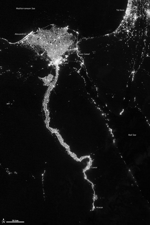
On October 13, 2012, the Visible Infrared Imaging Radiometer Suite (VIIRS) on the Suomi NPP satellite captured this nighttime view of the Nile River Valley and Delta. The Nile River Valley and Delta comprise less than 5 percent of Egypt’s land area, but provide a home to roughly 97 percent of the country’s population. Nothing makes the location of human population clearer than the lights illuminating the valley and delta at night.
Photo: NASA Earth Observatory image by Jesse Allen and Robert Simmon, using VIIRS day-night band data from the Suomi National Polar-orbiting Partnership. Suomi NPP is the result of a partnership between NOAA, NASA, and the Department of Defense. Find this image and others at http://earthobservatory.nasa.gov/NightLights.
Other phenomena observable with the day-night band become evident only at night. City lights reveal the human footprint on Earth in striking detail, which researchers have used to model the spatial distribution of economic activity. Carbon dioxide emissions from natural gas flares can be measured quantitatively. Fishing boats offshore in the Yellow and East China seas are seen to orient along political boundaries.
VIIRS is not the first instrument to look at nighttime lights. The U.S. Defense Meteorological Satellite Program has made observations with low-light sensors for 40 years. NOAA’s well-known nighttime lights images derive from those satellite data. The new VIIRS day-night band can better detect and resolve Earth's night lights; it is sensitive enough to detect lights as small as a single street lamp and even the nocturnal glow produced by the Earth’s own atmosphere.
Click here to view and download all available Suomi NPP “Earth Night Lights” images.
__________________________
The Suomi NPP mission is a bridge between NASA’s Earth Observing System and NOAA’s Polar-orbiting Operational Environmental Satellite System to the next generation of the operational environmental satellites, the Joint Polar Satellite System. Suomi NPP is both a NASA/NOAA joint mission and JPSS first mission. NOAA’s JPSS provides continuity of critical Earth observations, including the vast oceans, clouds, ozone, snow, ice, vegetation and atmosphere. NOAA works in partnership with NASA on all JPSS missions, ensuring an unbroken series of global weather data and increased weather prediction— securing a more ‘Weather Ready Nation.’
NOAA’s mission is to understand and predict changes in the Earth's environment, from the depths of the ocean to the surface of the sun, and to conserve and manage our coastal and marine resources. Join us on Facebook, Twitter and our other social media channels.
Posted December 5, 2012 ![]()


