
Argos Data Collection System (DCS)
|
Service Description
Argos DCS is an environmental data collection relay system that adds the benefits of providing global coverage and platform location. The system consists of in-situ data collection platforms equipped with sensors and transmitters and the Argos instrument aboard the NOAA Polar-orbiting Operational Environmental Satellites (POES). Flying the Argos system aboard polar-orbiting satellites provides worldwide coverage. |
Emergency Managers Weather Information Network (EMWIN)
|
Service Description Service operated by the National Weather Service that provides Emergency Weather Information rebroadcast through GOES satellites. With a low cost receiver, users in the GOES footprint can be forewarned of hazardous conditions. |
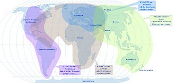
GEONETCast Americas
|
Service Description
GEONETCast is a near real time, global network of satellite-based data dissemination systems designed to distribute space-based, air-borne and in situ data, metadata and products to diverse communities. GEONETCast Americas serves most of North, Central, and South America using inexpensive satellite receiver stations based on Digital Video Broadcast (DVB) standards. |
GOES Data Collection System (DCS)
|
Service Description The GOES DCS is a data relay system used to transmit observations from surface based environmental platforms through NOAA's geostationary satellites, for delivery back to the platform owner. Government agencies (U.S. federal, state, local, and international) anywhere in the footprint of GOES can apply to use the system. Users are given frequency and time slots for their transmissions. |
Low-Rate Information Transmission (LRIT)
|
Service Description
LRIT is a collection of low resolution NOAA data and products, packaged into a single stream, and rebroadcast over NOAA geostationary satellites. Users can obtain this information with low cost ground systems. |
NOAA Direct Readout Conference
|
Service Description
The NOAA Direct Readout Conference held December 8th through 12th, 2008 in Miami, Florida was a great success. There has been significant interest in obtaining the presentations. Copies of the presentations can be found and downloaded from our Conference Presentations page. We hope you find the information useful. These NOAA Direct Readout Conferences highlight current GOES and POES data access, distribution, and prepares users for the upcoming changes to NOAA satellite programs. Users are presented with information on APT, HRPT, GVAR, ARGOS DCS, GOES DCS, LRIT, EMWIN, GEONETCast Americas and other NOAA systems. The upcoming GOES-R and NOPOESS Programs are also reviewed. |
NOAA Satellite Information System (NOAASIS)
Service Link |
Service Description
The Satellite Information System (NOAASIS) web site is a central location for finding information about NOAA environmental satellites (GOES and POES). Information is provided by various contributors within the National Environmental Satellite, Data, and Information Service (NESDIS) and the external satellite community. This site provides information of particular interest to users who operate their own direct readout receiving stations. Additional Links: Information Gateway - Provides essential information for NOAA satellite direct readout station operators and users of NOAA environmental satellite data. Quick Look - Direct access to limited navigational and operational information. Special Bulletins |
SARSAT
|
Service Description
As an integral part of worldwide search and rescue, NOAA operates the Search And Rescue Satellite Aided Tracking (SARSAT) System to detect and locate mariners, aviators, and recreational enthusiasts in distress almost anywhere in the world at anytime and in almost any condition. This information is then provided to search and rescue authorities. |
Contact Information: |
||
|
You are Here: http://www.osdpd.noaa.gov/ml/svcs/index.html
|