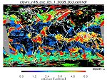
| CLAVR-x | Extended Clouds from AVHRR (Clavr-x) is a processing system used for cloud classification and derive cloud properties at the pixel level daily. Product Link |
|
|
||
| POES | Resolution: 1 Km | Frequency: Daily (Orbital via DDS) |
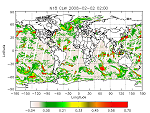
| Cloud Liquid Water (MSPPS) | The Cloud Liquid Water (CLW) is the vertically integrated cloud liquid water content in a vertical column of unit cross-sectional area extending all the way from the earth's surface to the top of the atmosphere. The NESDIS operational CLW product is derived from 23 and 31 GHZs channel measurements of the Advanced Microwave Sounding Units (AMSU) -A aboard on the NOAA POES satellites, and is expressed here in mm or kg/m2. The products are available at both pixel and grid levels.
Product Link |
|
|
||
| POES | Resolution: 45 Km at Nadir | Frequency: Orbital (Granule) or Daily |
| Sounder Cloud Top Pressure (GOES) | Cloud top pressure is derived from the GOES Sounder radiance information. The images are color enhanced to show the variation of height and type of clouds over a region. | |
|
||
| GOES | Resolution: 10 Km | Frequency: Hourly |
| Total Precipitable Water (SSM/I) | Also referred to as Water Vapor, this product shows the total atmospheric moisture over oceans. The water vapor is derived from the passive microwave sensor SSM/I, which has 7 channels of 19 GHz (H, V), 22 GHz (V), 37 GHz (H, V), and 85 GHz (H, V), where H is the horizontal polarization, V is the vertical polarization. The water vapor varies from 0 to 80 with accuracy of 0.1 kg/m^2. The product is updated once per day at 4 am EST. This product is originally generated by Fleet Numerical Meteorology and Oceanography Center (FNMOC). NOAA/NESDIS gets the product through an interagency program referred to as the Shared Processing Program in which NOAA, the US Air Force and US Navy participate. OSDPD converts the product into HDF-EOS and WMO BUFR formats and distributed to users. Product Link |
|
|
||
| POES | Resolution: 25 Km | Frequency: Every 4 Hours |
| Fog Depth | Product shows an estimate of the cloud layer thickness based on the IR brightness difference between GOES Imager channel 2 and 4. It is valid for single cloud layers only, preferably for radiation or advection fog.
Product Link |
|
|
||
| GOES | Resolution: 2 Km | Frequency: Hourly (at Night) |
| Fog/Low Cloud Imagery | Product shows the detection of fog and low clouds from the GOES Imager. This image product cannot distinguish fog from low clouds that do not reduce visibility at the ground. It is produced for the CONUS using GOES-East and for the Western U.S./Alaska using GOES-West. Frequent updates are essential for aviation interests. |
|
|
||
| GOES | Resolution: 2-8 Km | Frequency: 30 Minutes |
| Low Cloud Base Regional Imagery | The Low Cloud Base (LCB) products are generated from the GOES Imager and help to identify ceilings less than 1000 feet for aviation users. These products display possible Instrument Flight Rule (IFR) ceilings as red, and non-IFR ceilings as green. Some areas of IFR ceilings may not be detectable by the GOES product due to insufficient cloud depth, obscuration by cirrus, or insufficient temperature data. Conversely, some areas denoted as IFR by the GOES product may have higher cloud bases in areas of multiple inversions. Cloud heights (ft) observed at surface stations are overplotted in black. |
|
|
||
| GOES | Resolution: 2 Km | Frequency: Hourly (at Night) |