| Ensemble Tropical Rainfall Potential (eTRaP) | The eTRaP is a simple ensemble whose members are the 6-hourly totals from the single-orbit TRaPs. The eTRaP provides deterministic and probabilistic forecasts for each of four 6h time periods (e.g., 00-06h, 06-12h, 12-18h, 18-24h) as well as the 24 hour cumulative time period. Each eTRaP is made up of forecast using observations from potentially several microwave sensores--currently AMSU, TRMM, SSMI and AMSRE--initiailized at several observation times, and possibly using several different track forecasts. An eTRaP will be produced, centered on the synoptic hours (e.g., 00Z, 06Z, 12Z, 18Z), from single-orbit TRaP segments with start times up to 3 hours after the synoptic hour. Product Link |
|
|
||
| POES | Resolution: 4 Km | Frequency: 6 Hours |
| Microwave Rain Rate (MSPPS) | Rainfall rate is a measure of the intensity of rainfall. It is measured by calculating the amount of rain that falls to the earth surface per unit area per unit of time. The NESDIS operational RR product is derived from 89 and 150 GHZs channel measurements of the Advanced Microwave Sounding Units (AMSU) -A & -B aboard on the NOAA POES satellites, and is expressed in mm/hr. The products are available at both pixel and grid levels. Product Link More information on MSPPS Products |
|
|
||
| POES | Resolution: 16 Km at Nadir | Frequency: Orbital (Granule) or Daily |
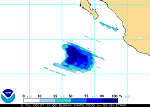
| Microwave Rain Rate (SSM/I, SSM/IS) | Product shows the rainfall intensity (mm/hr) over the Earth's surface. It is derived from SSM/I channels 19V, 19H, 22V, 37V, and 85V on an orbital basis. Orbital and Mapped - SSM/I Product Link | SSM/IS Product Link |
|
|
||
| POES | Resolution: 15-50 Km | Frequency: Every 4 Hours |
| Precipitable Water Index | Product shows the amount of precipitable water derived from the difference between AVHRR channels 4 and 5. Precipitable water is defined as the total atmospheric water vapor contained in a vertical column of area extending between any two specified levels. This product is also known as the brightness temperature difference. Product Link |
|
|
||
| POES | Resolution: 15 Km | Frequency: Weekly |
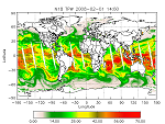
| Rainfall Hydro Estimator | The Hydro-Estimator (H-E) version of the Auto-Estimator (AE) was developed by the Office of Research and Applications (ORA) of the National Environmental Satellite, Data and Information Service (NESDIS). The Hydro-Estimator algorithm differs from the original AE by using a brightness temperature screening technique. It adjusts the rain rate assigned to each picture element (pixel) according to the surrounding pixel temperatures. This helps separate raining and non-raining pixels and decreases the need for radar screening. It also helps focus rainfall estimate totals into more clearly defined maximums. There is less of a tendency for overestimating for very cold cloud tops using the H-E, and it does a much better job of estimating for large mesoscale convective complexes (MCC's). The H-E also has a different way of handling the moisture corrections, and also produces more frequent products every 15 minutes for all except the 24 hour totals. The 1 hour H-E totals are available on the NWS AWIPS system as a graphic for the whole CONUS every hour. Product Link |
|
|
||
| GOES | Resolution: 4 Km | Frequency: 15 min.; 1 hr. on AWIPS |
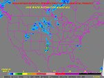
| Satellite Precipitation Estimate Messages (SPENES) | Satellite-derived precipitation estimates (SPE’s) and satellite-based trend guidance are provided to the National Weather Service (NWS) when heavy convective rain threatens to produce flash flooding over the lower 48 states, Puerto Rico, and Hawaii. Support is also provided for heavy rain and snow associated with winter storms, and for heavy lake effect snow. This information is disseminated via Satellite Precipitation Estimate messages (SPENES), which are available on the Advanced Weather Interactive Processing System (AWIPS) and the Internet. “SPENES” is the AWIPS ID, and the WMO header for this message is “TXUS20 KNES”. In composing SPENES messages, the following data are used: GOES infrared (IR), visible (VIS), and water vapor (WV) imagery; GOES Sounder data and Derived Product Imagery (DPI); GOES satellite-derived winds; Microwave data from various Polar orbiting satellites; and surface and upper air data.
Product Link (Text with Graphics attached when available) |
|
|
||
| GOES and POES | Resolution: N/A | Frequency: Event Driven |
| Total Precipitable Water (ATOVS) | This product also known as Total Atmospheric Moisture (mm) with a 40 km resolution. It is derived from HIRS/3 channels 10-12 and is generated from the ATOVS processing system. Total precipitable water is defined as the vertically integrated water vapor in a column extending from the surface to the top of the atmosphere. Product Link |
|
|
||
| POES | Resolution: 45 Km | Frequency: Orbital |
| Total Precipitable Water (MSPPS) | The Total Precipitable Water (TPW) is the vertically integrated water vapor content in a vertical column of unit cross-sectional area extending all the way from the earth’s surface to the top of the atmosphere. The NESDIS operational TPW product is derived from 23 and 31 GHZs channel measurements of the Advanced Microwave Sounding Units (AMSU) -A aboard on the NOAA POES satellites, and is expressed here in mm or kg/m2. The products are available at both pixel and grid levels. Product Link |
|
|
||
| POES | Resolution: 45 Km at Nadir | Frequency: Orbital (Granule) or Daily |
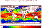
| Total Precipitable Water (SSM/I) | Also referred to as Water Vapor, this product shows the total atmospheric moisture over oceans. The water vapor is derived from the passive microwave sensor SSM/I, which has 7 channels of 19 GHz (H, V), 22 GHz (V), 37 GHz (H, V), and 85 GHz (H, V), where H is the horizontal polarization, V is the vertical polarization. The water vapor varies from 0 to 80 with accuracy of 0.1 kg/m^2. The product is updated once per day at 4 am EST. This product is originally generated by Fleet Numerical Meteorology and Oceanography Center (FNMOC). NOAA/NESDIS gets the product through an interagency program referred to as the Shared Processing Program in which NOAA, the US Air Force and US Navy participate. OSDPD converts the product into HDF-EOS and WMO BUFR formats and distributed to users. Product Link |
|
|
||
| POES | Resolution: 25 Km | Frequency: Every 4 Hours |
Additional Links: