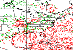
| High Density Infrared Cloud Drift Winds |
Product shows the wind vector, consisting of speed and direction, at an assigned height (100-400 mb, 400-700 mb, and below 700 mb) above the Earth's surface based on the infrared energy signatures and guidance from corresponding numerical weather forecast parameters. It is generated from geostationary satellites using Imager data in hemispheric and mercator projections by tracking features in the infrared window channel data. Coverage: GOES Imager - 70N to 70S MODIS - both North and South Poles Product Link |
|
|
||
| GOES | Resolution: 60 Km | Frequency: 3 Hours |
| MODIS | Resolution: 30 Km | Frequency: 2 Hours |
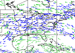
| High Density Visible Cloud Drift Winds |
Product shows the wind vector, consisting of speed and direction, at an assigned height (600-800 mb and 801-950 mb) above the Earth's surface based on energy signatures and guidance from corresponding numerical weather forecast parameters. It is generated from geostationary satellites using Imager data and derived by tracking features in the visible channel data. Coverage: GOES Imager - 70N to 70S Product Link |
|
|
||
| GOES | Resolution: 30 Km | Frequency: 3 Hours |
| High Density Water Vapor Cloud Drift Winds |
Product shows the wind vector, consisting of speed and direction, at an assigned height (100-250 mb, 250-350 mb, and 350-550 mb) above the Earth's surface based on energy signatures and guidance from corresponding numerical weather forecast parameters. Coverage: GOES Imager - 70N to 70S GOES Sounder - CONUS with the adjacent Ocean (channels 10 and 11) MODIS - both North and South Poles Product Link |
|
|
||
| GOES (Imager) | Resolution: 60 Km | Frequency: 3 Hours |
| GOES (Sounder) | Resolution: 70 Km | Frequency: 3 Hours |
| MODIS | Resolution: 30 Km | Frequency: 2 Hours |
| GOES High Density Winds: 30 Days of Images |
High Density Cloud Drift winds generated every three hours and showcased in near real time, are being archived for 30 days. Choose Day/Time for Full Disk, then click on sector for Northwest, Northeast, Southwest or Southeast Quadrant. This represents a collection of the GOES Imager Visible, Infrared and Water Vapor High Density Cloud Drift Winds (as described above), retained for thirty days.
Coverage: GOES Imager - 70N to 70S Product Link |
|
|
||
| GOES | Resolution: 30 Km | Frequency: 3 Hours |
| Jason-2 Winds | Jason-2 wind speeds are estimated from the shape and intensity of the altimeter radar echo, representing ~2-5 km footprint depending on sea state, to within 1.6 meters/second. Product Information Handbook Link (PDF 2.4 Mb) |
|
 |
||
| OSTM/Jason-2 | Resolution:
~7 km along track (1 Hz) |
Frequency: 10-14 times each day |
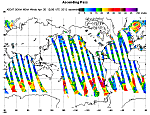
| ASCAT Winds | The Advanced Scatterometer (ASCAT) ocean surface winds are a 10 meter neutral stability wind. These products are processed by NOAA/NESDIS utilizing measurements from ASCAT aboard the EUMETSAT METOP polar orbiting satellite. For closer examination of the wind fields, a data image is further divided into 30x20 degree bins between latitudes 80N to 80S and longitudes 180W to 180E, forming a HTML link map for the regions of interest. Just click on the desired geographical location and a closer look should be provided. The European ASCAT system provides a partial mitigation for QuikSCAT surface winds. The global wind images display the available data from the previous 22 hours up to the image creation time. Click here for the ocean surface winds from the near real-time (NRT) observation data. Two resolutions are available, 25 Km and 50 Km Product Link Related Links: |
|
|
||
| POES | Resolution: 12.5 - 25 Km | Frequency: Twice per Day |
| Wind Speed (SSM/I) | Product shows wind speed over oceans. The wind speed is derived from the passive microwave sensor SSM/I, which has 7 channels of 19 GHz (H, V), 22 GHz (V), 37 GHz (H, V), and 85 GHz (H, V), where H is the horizontal polarization, V is the vertical polarization. The wind speed has accuracy of 0.1 m/s. The product is updated once per day at 4 am EST. This product is originally generated by Fleet Numerical Meteorology and Oceanography Center (FNMOC). NOAA/NESDIS gets the product through an interagency program referred to as the Shared Processing Program in which NOAA, the US Air Force and US Navy participate. OSDPD converts the product into HDF-EOS and WMO BUFR formats and distributed to users. Product Link |
|
|
||
| POES | Resolution: 25 Km | Frequency: Daily |