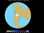
| Sea Ice Concentration (MIRS & MSPPS) |
Product shows the percentage of sea ice within the instrument's field of view. It is derived from AMSU-A channels 1-3 and 15 and AMSU-B channel 16 and is generated from the MSPPS processing system on an orbital basis or mapped on a polar stereographic 1/8 mesh grid. Ice concentration is defined as the fraction of a given area of sea water covered by ice. Product Links: Orbital | Mapped | MIRS More information on MSPPS ProductsMore information on MIRS Products |
|
|
||
| POES | Resolution: 45 Km | Frequency: Orbital and Daily |
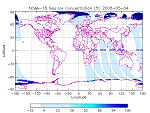
| Sea Ice Concentration (SSM/I) | Product shows sea ice concentration over oceans. The sea ice concentration is derived from the passive microwave sensor SSM/I, which has 7 channels of 19 GHz (H, V), 22 GHz (V), 37 GHz (H, V), and 85 GHz (H, V), where H is the horizontal polarization, V is the vertical polarization. The ice concentration is defined as the fraction of a given area of sea water covered by ice with accuracy of 5%. The product is updated once per day at 4 am EST. This product is originally generated by Fleet Numerical Meteorology and Oceanography Center (FNMOC). NOAA/NESDIS gets the product through an interagency program referred to as the Shared Processing Program in which NOAA, the US Air Force and US Navy participate. OSDPD converts the product into HDF-EOS and WMO BUFR formats and distributed to users. Product Link |
|
|
||
| POES (DSMP) | Resolution: 25 Km | Frequency: Daily |