Positioning America for the Future
Vision: Everyone accurately knows where they are and where other things are anytime, anyplace.
NGS 10 Year and Strategic
Plans provide a more detailed description of NGS and the vision for the future
looking ten years out.
Mission:
The Mission of NOAA's National Geodetic Survey (NGS) is "to
define, maintain and provide access to the National Spatial Reference System to meet
our nation's economic, social, and environmental needs."
What We Do:
NGS provides the framework for all positioning activities in the Nation. The foundational elements - latitude, longitude, elevation, shoreline information and their changes over time - contribute to informed decision making and impact a wide range of important activities including mapping and charting, navigation, flood risk determination, transportation, land use and ecosystem management. NGS' authoritative spatial data, models, and tools are vital for the protection and management of natural and manmade resources and support the economic prosperity and environmental health of the Nation.
Organization:
NGS Organization
Information describes NGS's organizational structure.
Core Values
NGS adopted a set of core values in 2010. NGS Values provides a more detailed
description of the core values that are most important to us: Customer Focus,
Excellence, Responsiveness, Respect, Creativity and Accountability.
NGS Products and Services
An overview of major NGS projects and services is provided below.
| CORS | Height Modernization |
| GRAV-D | ECO/COASTAL |
| Airport Surveys | OPUS |
| VDatum | GPS Satellite Orbits |
| Shoreline Mapping | State Advisor Program |
| Emergency Response Imagery |
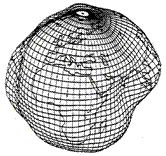
What is Geodesy?
Geodesy is the science concerned with determining the size and shape of the Earth
and the location of points upon its surface.
Why is Geodesy Important?
The Earth is an irregular surface and is difficult to model. Accurate positions are
required for a wide variety of applications including mapping and charting, flood risk
determination, transportation, land use and ecosystem management.
How can I learn more about Geodesy?
Geodesy On NOAA's National Ocean Service web site, you will find two sections devoted to learning about geodesy: an online tutorial and an educational roadmap to resources.
 For questions, please contact
the Communications and Outreach
Branch.
For questions, please contact
the Communications and Outreach
Branch.

