Nimbus
Phase: Past
Launch Date: August 27, 1964
Mission Project Home Page - http://nssdc.gsfc.nasa.gov/earth/nimbus.html

The Nimbus Program
The Nimbus satellites, first launched in 1964, carried a number of instruments: microwave radiometers, atmospheric sounders, ozone mappers, the Coastal Zone Color Scanner (CZCS), infrared radiometers, etc. Nimbus-7, the last in the series, provided significant global data on sea-ice coverage, atmospheric temperature, atmospheric chemistry (i.e. ozone distribution), the Earth's radiation budget, and sea-surface temperature.
The project objectives were to provide improved photographs of local cloud conditions by an automatic picture transmission (APT) system, and to evaluate an advanced vidicon camera system for daylight coverage and a high-resolution infrared radiometer system for night-time cloud-cover observation.
Nimbus missions have sent back over 27,000 high-resolution photos; at its height they photographed 70 percent of the world each day. The APT system supplied daytime photos to more than 60 low-cost ground stations. Radiometer photos were remarkably clear and covered a 12,500-square mile area.
Nimbus-1
Nimbus-1 was a test of the Nimbus spacecraft configuration and provide improved cloud photographs using the APT system deployed on TIROS-8. Advanced cameras and high-resolution infrared radiometers were also to be tested for improved daylight as well as night cloud-cover conditions.
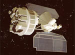
The spacecraft was designed in two sections. The lower circular ring housed the meteorological sensors and electronics. The upper hexagonal section contained the altitude control system and had two solar panels (containing 10,500 individual panels) attached to its sides. The two sections were constructed by a magnesium truss. The lower ring was 57 inches in diameter. The total spacecraft height was 118 inches while the width across the solar panels was 134 inches. The total weight of the spacecraft was 830 pounds.
The craft contained three cameras with direct readout and delayed readout capabilities. A high-resolution infrared radiometer operated in the 3.4 to 4.2 micron region. Two horizon scanners, Sun sensors and freon gas jets provided the altitude control.
Premature Agena cutoff left the craft in an elliptical orbit rather than a more circular one, and one of the solar panels failed 26 days into the mission. In spite of these problems, 27,000 pictures were taken and 60 ground stations were involved in the direct readout of this imagery. The infrared imagery was much clearer than those sampled by the TIROS series.
Participants: NASA, General Electric, ITT, Fairchild - Hiller, RCA, US Weather Bureau
Nimbus-1 Stats:
- Launch Date: August 28, 1964
- Operational Period: Operational until September 23, 1964
- Launch Vehicle: Thor-Agena B
- Launch Site: Vandenberg Air Force Base, CA
- Type: Weather Satellite
Nimbus-B
Nimbus-B (scheduled to be Nimbus-2) was to be the first US weather satellite to make day and night global measurements from space of temperatures at varying levels in the atmosphere. Other mission objectives included providing support for international programs designed to gather vital oceanographic data, and large-scale atmospheric data for use in newly designed computer prediction models.
Two minutes after launch, a booster malfunction forced a command destruct of the rocket and satellite. The rocket and spacecraft debris fell into the Pacific Ocean between Jalama Beach and San Miguel Island.
Participants: NASA, General Electric, ITT, ESSA, Woods Hole Oceanographic Institute, US Weather Bureau, USAF Air Weather Service, Bureau of Commercial Fisheries, Nuclear Regulatory Commission.
Nimbus-B Stats:
- Launch Date: May 18, 1968
- Operational Period: Failed
- Launch Vehicle: Thorad (Long-Tank Thor)
- Launch Site: Vandenberg Air Force Base, CA
- Type: Weather Satellite
Nimbus-3
Nimbus-3 was a replacement for Nimbus B which was destroyed in a launch failure. Nimbus-3 was the first US weather satellite to make day and night global measurements from space of temperatures at varying levels in the atmosphere. Other mission objectives included providing support for international programs designed to gather vital oceanographic data, and large-scale atmospheric data for use in newly designed computer prediction models of the atmosphere.
The spacecraft was designed and configured the same as the Nimbus-1 and -2 crafts. Seven new experiments were on board this craft (identical to those on the aborted Nimbus-B) making the total weight of the spacecraft the largest ever for a meteorological satellite--1269 pounds.
The craft contained an Infrared Interferometer Spectrometer (IRIS) to measure atmospheric temperature, water vapor, and ozone in the vertical. A Satellite Infrared Spectrophotometer (SIRS) was used to take similar temperature readings as the IRIS for comparison purposes. An Interrogation Recording and Location System (IRLS) was used to locate, identify and relay transmissions from data gathering buoys on the surface of the Earth. A Monitor of Ultraviolet Solar Energy (MUSE) was used to measure the amount of ultraviolet radiation reaching the atmosphere from the Sun. The Image Dissector Camera (IDC) replaced the old vidicon cameras which had been used to provide APT to surface ground stations. A High Resolution and Medium Resolution Infrared radiometer (HRIR and MRIR) were used to provide infrared images at night as on the previous Nimbus series satellites. The craft was powered by 10,500 solar cells and two SNAP-19 nuclear powered generators.
The craft was placed in Sun-synchronous orbit and transmission of data from all of the experiments was completed as scheduled.
Participants: NASA, General Electric, ITT, ESSA, Woods Hole Oceanographic Institute, US Weather Bureau, USAF Air Weather Service, Bureau of Commercial Fisheries, Nuclear Regulatory Commission
Nimbus-3 Stats:
- Launch Date: April 13, 1969
- Operational Period: Until January 22, 1972
- Launch Vehicle: Thorad-Agena D
- Launch Site: Vandenberg Air Force Base, CA
- Type: Weather Satellite
Nimbus-4
The Nimbus-4 satellite continued the research, development and testing of new meteorological sensors, systems and systems configurations to measure atmospheric temperature, water vapor and ozone. Those sensors which could be used in operational weather analysis and prediction were to be added to the TIROS/ESSA operational weather satellite program.
The spacecraft was designed and configured the same as all previous Nimbus satellites. The total weight of the spacecraft was the largest ever for a meteorological satellite-1366 pounds. The excess weight of Nimbus-4 was due to a piggyback TOPO I experiment designed to test transponders and antennas for space-ground triangulation exercises for the US Army for ground tactical positioning, and the addition of four new experiments to the seven flown on Nimbus-3.
The new experiments included a backscatter ultraviolet spectrometer, a filter wedge spectrometer, a selective chopper radiometer, and a temperature, humidity and infrared radiometer. The SIRS, HRIR and MRIR flown on Nimbus 3 were removed from Nimbus-4 to make room for the new experiments. The craft was placed in Sun-synchronous orbit and transmission of data from all of the experiments was completed as scheduled.
Participants: NASA, General Electric, ESSA, US Weather Bureau, USAF Air Weather Service, Oxford University, University of Wisconsin, University of Maryland
Nimbus-4 Stats:
- Launch Date: April 8, 1970
- Operational Period: Over 10 years until it was deactivated on September 30, 1980
- Launch Vehicle: Thorad-Agena D
- Launch Site: Vandenberg Air Force Base, CA
- Type: Weather Satellite
Nimbus-5
The Nimbus-5 satellite continued research, development and testing of new meteorological sensors, systems and systems configurations to measure atmospheric temperature, water vapor and ozone. Those sensors which could be used in operational weather analysis and prediction were to be added to the NOAA operational weather satellite program.
The spacecraft was designed and configured the same as all previous Nimbus satellites. The total weight of the spacecraft was the largest ever for a meteorological satellite-1580 pounds. The excess weight of Nimbus-5 was due to the addition of four new experiments to the nine flown on Nimbus-4.
The new experiments included an electrically scanning microwave radiometer, an infrared temperature profile radiometer, a microwave spectrometer, and a surface composition mapping radiometer. Improved versions of the chopper radiometer and the temperature, humidity and infrared radiometer were also flown.
The craft was placed in Sun-synchronous orbit and transmission of data from all of the experiments was completed as scheduled.
Participants: NASA, General Electric, NOAA, US Weather Bureau, MIT, Jet Propulsion Lab, Oxford University, Heriot Watts University
Nimbus-5 Stats:
- Launch Date: December 10, 1972
- Operational Period: Over 10 years until it was deactivated on March 29, 1983
- Launch Vehicle: Delta 900
- Launch Site: Vandenberg Air Force Base, CA
- Type: Weather Satellite
Nimbus-6
The Nimbus-6 satellite continued research, development and testing of new meteorological sensors, systems and systems configurations to measure atmospheric temperature, water vapor and ozone. Those sensors which could be used in operational weather analysis and prediction were to be added to the NOAA operational weather satellite program.
The spacecraft was designed and configured the same as all previous Nimbus satellites. The total weight of the spacecraft was the largest ever for a meteorological satellite-1823 pounds.
Nimbus-6 carried nine instruments. They were an Earth Radiation Budget experiment, an Electrically Scanning Microwave Radiometer, a High Resolution Infrared Radiation Sounder, a Limb Radiance Inversion Radiometer, a Pressure Modulated Radiometer, a Scanning Microwave Spectrometer, a Tracking and Data Relay experiment, a Temperature, Humidity Infrared Radiometer and a Tropical Wind, Energy Conversion and Reference Level experiment.
The craft was placed in Sun synchronous orbit and transmission of data from all of the experiments was completed as scheduled.
Participants: NASA, NCAR, General Electric, NOAA, US Weather Bureau, MIT, Jet Propulsion Lab, Oxford University
Nimbus-6 Stats:
- Launch Date: June 12, 1975
- Operational Period: Deactivated with Numbus-5 on March 29, 1983
- Launch Vehicle: Two-stage Delta 2910
- Launch Site: Vandenberg Air Force Base, CA
- Type: Weather Satellite
Nimbus-7
The Nimbus-7 satellite was the first global monitor of man-made and natural pollutants in the Earth's atmosphere will be made with this spacecraft in cooperation with a team of about 50 international scientists.
The objective of Nimbus-7 was to determine the physical characterization of the global atmosphere, the oceans, the ocean-atmosphere interface, and the Earth's heat balance. Experiment data was to be transmitted to Earth immediately. The spacecraft was designed and configured the same as all previous NIMBUS satellites. The total weight of the spacecraft was the largest ever for a meteorological satellite -- 2176 pounds!
NIMBUS-7 carried eight highly complex sensors which were all improved versions of sensors previously flown on NIMBUS satellites. They were a Limb Radiance Inversion Radiometer, a High Resolution Infrared Radiation Sounder, an Earth Radiation Budget experiment, a Scanning Multichannel Microwave Radiometer (SMMR), a Pressure Modulated Radiometer, a Solar Backscatter UV/Total Ozone Mapping Spectrophotometer, a Temperature, Humidity Infrared Radiometer and a Tropical Wind, Energy Conversion and Reference Level experiment.
The craft was placed in Sun-synchronous orbit and transmission of data from all of the experiments was completed as scheduled. For the first time NASA and ESA (European Space Agency) were able to receive data concerning the global atmosphere in real time.
Participants: NASA, ESA, NOAA, NCAR, Johns Hopkins University, Oxford Unversity
Nimbus-7 Stats:
- Launch Date: October 24, 1978
- Operational Period: Operational through 1994, although the TOMS instrument failed in May of 1993
- Launch Vehicle: Two-stage Delta 2910
- Launch Site: Vandenberg Air Force Base, CA
- Type: Weather Satellite