
Research: Observatories and Field Programs
Observatories
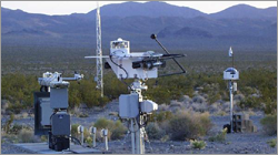
 Atmospheric Baseline Observatories
The Atmospheric Baseline Observatories exist to conduct long-term measurements of atmospheric gases, aerosol particles and solar radiation to provide the basis for assessing the prospects of change in the global climate and health of the atmosphere.
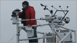 Arctic Atmospheric Observatories
The Arctic Atmospheric Observatory program is establishing long-term intensive measurements of clouds, radiation, aerosols, surface energy fluxes and chemistry in three different Arctic climate regimes. These measurements will be used to determine the mechanisms that drive climate change through a combination of process studies, satellite validation and modeling studies.
Observational Networks
 Boundary Layer Profiler Network
A seasonally-deployed, research network of boundary layer profilers which makes regional observations of high resolution atmospheric winds and temperatures to improve the understanding of factors impacting regional weather and air quality forecasting.
 Surface Radiation Budget Network (SURFRAD)
 SURFRAD's primary objective is to support climate research with accurate, continuous, long-term measurements of the surface radiation budget over the United States. Seven stations operate in climatologically diverse regions of Montana, Colorado, Illinois, Mississippi, Pennsylvania, Nevada and South Dakota. Observations from SURFRAD are used for evaluating satellite-based estimates of surface radiation, and for validating hydrologic, weather prediction, and climate models.
Current Field Programs
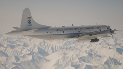 Aerosol, Radiation, and Cloud Processes affecting Arctic Climate (ARCPAC)
During the International Polar Year of 2008, NOAA will engage in a field campaign targeted at improving understanding of shorter-lived climate forcing processes which may be contributing to the decrease in seasonal Arctic sea ice coverage and thickness. This effort will be focused on direct measurements of properties and processes to reduce uncertainty in radiation and climate models. Measurements will be made in the Alaskan Arctic to closely coordinate with remote sensing and in situ observations planned for aircraft and ground sites in the vicinity of Barrow, Alaska.
 Hydrometeorological Testbed (HMT)
HMT conducts research on precipitation and weather conditions that can lead to flooding, and fosters transition of scientific advances and new tools into forecasting operations. HMT's outputs support efforts to balance water resource demands and flood control in a changing climate.