| NOAA Magazine || NOAA Home Page |
NOAA
UNVEILS HURRICANE KATRINA WEB SITE CAPTURING THE STORM’S POWER
AND AFTERMATH
Web Site Offers Comprehensive Look at the Historic Storm and NOAA’s
Response
 August
29, 2006 � A year to the day after Hurricane
Katrina became the most destructive hurricane ever to strike the
United States, NOAA launched a new Web site detailing the development
of the storm, its power and destruction. The site also highlights NOAA’s
multi-faceted response to the storm’s aftermath, including floods,
testing fisheries, clearing waterways, identifying and cleaning up oil
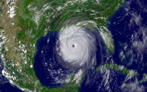
spills. In addition, there are dozens of photos and satellite images
that capture Hurricane Katrina’s march into the Gulf of Mexico
and its subsequent landfall on the U.S. Gulf Coast. (Click NOAA
satellite image for larger view of Hurricane Katrina taken Aug. 28,
2005, as the storm’s outer bands lashed the Gulf Coast of the
United States a day before making landfall and leaving a path of destruction
in its wake. Click here
for high resolution version. Please credit “NOAA.”)
| Two days after Hurricane Katrina devastated the U.S. Gulf Coast, A NOAA Bell 212 Twin Huey Helicopter flew support and survey missions from August 31 to September 21 from Panama Beach, Fla., to New Orleans. Commander Mark Moran, of the NOAA Commissioned Corps, who was one of three NOAA helicopter pilots that flew more than 100 hours over the affected areas, took dozens of photos of the destruction left in Katrina’s wake. A year later Moran talked about his experience from NOAA headquarters in Washington, D.C. (mp3) | |
| 1) Moran said in parts of the Gulf Coast Katrina’s devastation was complete. :33 | 4) Moran said they could smell New Orleans while flying 500 feet above the flooded city. :15 |
| 2) Moran describes how it was flying the NOAA helicopter over New Orleans. :28 | 5) Moran said he’s hopeful for the region’s recovery. :19 |
| 3) Moran said he just couldn’t believe the utter destruction while flying over the Gulf region. :12 | 6) Moran said the swath of destruction was wide. :14 |
| Podcast | Natural sound of NOAA helicopter flying over Gulf Coast surveying damage of Hurricane Katrina. :47 |
On August 28, 2005, Hurricane Katrina was in the Gulf of Mexico where it powered up to a Category 5 storm on the Saffir-Simpson hurricane scale packing winds estimated at 175 mph.
At 7:10 a.m. EDT on August 29, Hurricane Katrina made landfall in southern Plaquemines Parish, La., just south of Buras, as a Category 3 hurricane. Maximum winds were estimated near 125 mph to the east of the center.
Although Katrina will be recorded as the most destructive storm in terms of economic losses, it did not exceed the human losses in storms such as the Galveston Hurricane of 1900, which killed as many as 6,000-12,000 people, and led to almost complete destruction of coastal Galveston.
Hurricane Andrew, in 1992, cost approximately $21 billion in insured losses (in today's dollars), whereas estimates from the insurance industry as of late August 2006, have reached approximately $60 billion in insured losses (including flood damage) from Katrina. The storm could cost the Gulf Coast states as much as an estimated $125 billion.
Hundreds of NOAA employees from many divisions of the agency were involved with Hurricane Katrina, and many were affected directly by the storm. Some NOAA facilities had to be evacuated as Katrina bore down on the Gulf Coast.
During the 2005 Atlantic hurricane season, the NOAA P-3 turboprop hurricane hunter aircraft flew around and into 11 named storms—including Katrina—accounting for 73 missions, which translates into 480 flight hours. The P-3s also flew into the eyewall of the storms 109 times.
NOAA’s Gulfstream-IV jet flew 50 missions, for a total 389 flight hours.
NOAA’s Citation aircraft flew 50 aerial photography missions after Hurricanes Katrina, Ophelia and Rita, which amounted to 105 flight hours and thousands of high resolution photos of the storms’ damage.
In 2007 NOAA, an agency of the U.S. Commerce Department, celebrates 200 years of science and service to the nation. Starting with the establishment of the U.S. Coast and Geodetic Survey in 1807 by Thomas Jefferson much of America's scientific heritage is rooted in NOAA. The agency is dedicated to enhancing economic security and national safety through the prediction and research of weather and climate-related events and information service delivery for transportation, and by providing environmental stewardship of the nation's coastal and marine resources. Through the emerging Global Earth Observation System of Systems (GEOSS), NOAA is working with its federal partners, more than 60 countries and the European Commission to develop a global monitoring network that is as integrated as the planet it observes, predicts and protects.
Relevant Web Sites
NOAA Katrina Portal
Media
Contact:
Greg Hernandez, NOAA,
(202) 482-3091