
- AboutNOAA National Weather Service is the U.S. Federal agency responsible for weather, water & climate forecasts & warnings.
For the official source of information about the National Weather Service, please visit our homepage at http://www.weather.gov/.

- Also On
- ...Heavy Snow to Impact California Mountains...
A powerful storm system will press into the West Coast early Monday bringing cold and wet weather to the region, as well as the first significant snow of the season. The Sierra Nevada Range i...s forecast to receive up to 18 inches of snow at the higher elevations. Yosemite National Park could see 8 inches of snow. Winter Storm Warnings and Winter Weather Advisories are in effect across this region.See More
Details...
http://forecast.weather.gov/wwamap/wwatxtget.php?cwa=sto&wwa=winter+storm+warning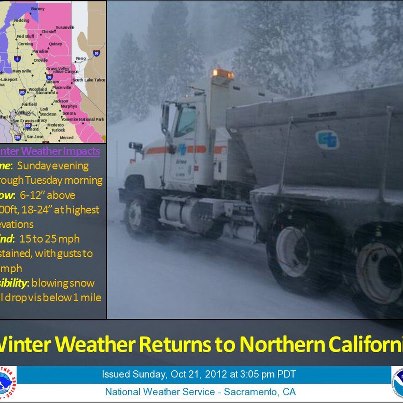
- LikesSee All
- US National Weather Service Greenville-Spartanburg SCGovernment Organization
- US National Weather Service Huntsville AlabamaGovernment Organization
- US National Weather Service Morristown TennesseeGovernment Organization
- US National Weather Service Southeast River Forecast CenterGovernment Organization
- US National Weather Service Key West FloridaGovernment Organization
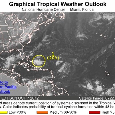
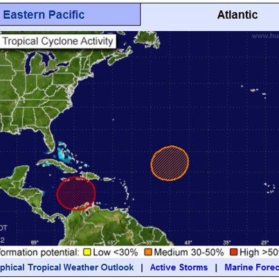
- While the focus across the western U.S. has shifted to winter weather, the tropics are by no means quieting down. There are two areas of interest in the Atlantic Basin and one area in the eastern Pacific. The red area over the Central Caribbean has a 70% chance of Tropical Cyclone formation over the next 48 hours. For more information on these tropical disturbances, visit: http://www.nhc.noaa.gov/?atlc
- An early season winter storm will move into Northern California and Northern Nevada early next week. This will bring gusty winds, rain and snow. Moderate snow accumulations are expected in the Eastern Sierra from Lake Tahoe northward. This is a good time to review your winter driving tips. Read more:
http://forecast.weather.gov/wwamap/wwatxtget.php?cwa=rev&wwa=winter+storm+watch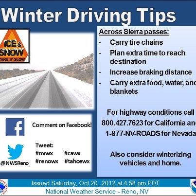
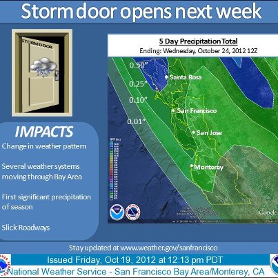
- The storm system that will bring heavy snow to the western mountains this weekend will also bring a major pattern change to the coastal areas of California early next week, including the San Francisco Bay Area. The first in a series of cold...fronts is forecast to move through the region Monday bringing the first significant rainfall of the season. After a brief break on Tuesday, stronger and wetter storms are forecast to buffet the area later next week. Read more here: http://www.wrh.noaa.gov/total_forecast/getprod.php?wfo=mtr&sid=MTR&pil=SPSSee More
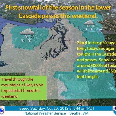
- An early season winter storm impacting the west will bring the first significant snow to many areas this weekend and into early next week. The storm will drop more than a foot of snow in the Olympic and Cascade Ranges, the Sierra Nevada Range and the northern Rockies over the next few days. Check out: http://www.hpc.ncep.noaa.gov/pwpf/wwd_accum_probs.php?fpd=24&ptype=snow
- We achieved a historic technological milestone! Today, the NWS Doppler radar in Pocatello, Idaho was the 28th and final radar in the NWS Western Region to be upgraded with dual polarization technology. In supporting a Weather-Ready Nation, ...the nationwide radar upgrade will be completed next spring.See More
For more information on the updgade, please visit: http://www.nws.noaa.gov/com/weatherreadynation/news/080212_dual.html )
Photo: The Dual Pol INCO Team 4 workers verify antenna clearance before beginning their 18 hour data quality check. Picture taken by WFO Pocatello ET Bryan Till 10/19/2012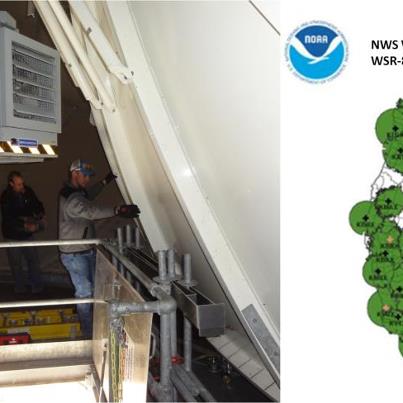
- ...Storm System Moves into the Pacific NW...
A strong storm system is moving into the Pacific NW tonight and tomorrow, bringing with it significant winter weather. Snowfall accumulations of 4-8 inches are likely with amounts over a foot likely in the higher mountain passes, making travel hazardous. Strong winds with gusts of up to 50 mph possible.
http://go.usa.gov/YUee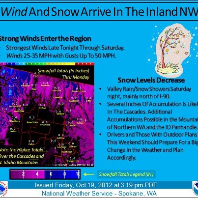
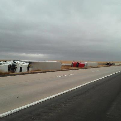
- Strong winds in the Plains today have caused travel disruptions from the Dakotas to Oklahoma. This picture shows several trucks blown over on Interstate 90 near Belvidere, SD. This is just one of several reports of traffic accidents in the region caused by strong winds and/or blowing dust.
U.S. National Weather Service shared a link.
NOAA announces 2012 Winter Outlook (Dec - Jan - Feb). A wavering El Niño makes this year’s winter forecast less certain than previous years.- ...Strong Winds Impacting the Plains...
A powerful storm system moving through the Upper Midwest is creating strong winds across much of the Northern and Central Plains. Numerous High Wind Warnings and Wind Advisories are in effect from Mo...ntana to Kansas. Winds topping 60 mph could cause blowing dust, localized power outages, and quickly spreading wildfires through Thursday.See More
Details...
http://www.hpc.ncep.noaa.gov/discussions/hpcdiscussions.php?disc=pmdspd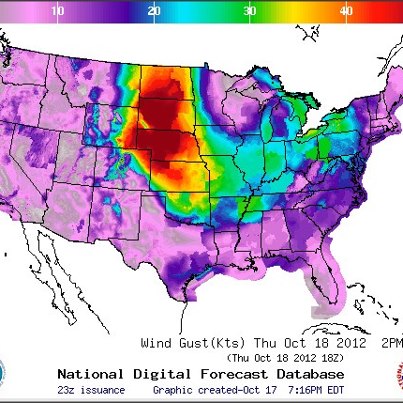
- The NWS Storm Prediction Center is forecasting a risk of severe thunderstorms this afternoon and evening for parts of the Ohio, Tennessee and Mississippi Valleys, stretching from southern Illinois to Mississippi and Louisiana. Damaging winds will be the primary threat, though large hail and tornadoes — some of which could be strong — are also possible. Details...
http://go.usa.gov/Rvk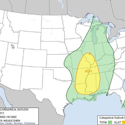
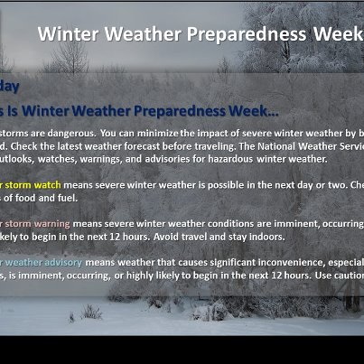
- Do you know the difference between a Winter Storm Watch, Warning and Advisory? Check out this graphic from NWS Alaska's Winter Weather Preparedness Week for more information.
- Swells from Hurricane Rafael — currently located about 200 miles south of Bermuda — are expected to affect portions of the U.S. East Coast during the next couple of days. This could create a dangerous rip current situation along coastal bea...ches. Details...See More
Latest on Rafael from the National Hurricane Center:
http://www.nhc.noaa.gov/#RAFAEL
NWS Rip Current Statements currently in effect:
http://forecast.weather.gov/wwamap/wwatxtget.php?cwa=usa&wwa=Rip Current Statement
NWS Beach Hazard Statements currently in effect:
http://forecast.weather.gov/wwamap/wwatxtget.php?cwa=usa&wwa=Beach Hazards Statement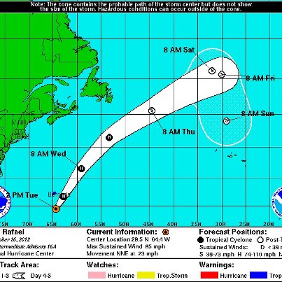
U.S. National Weather Service shared a link.
Watch video of yesterday's ribbon cutting ceremony at the new NOAA Center for Weather and Climate Prediction:
http://youtu.be/bTkprW4Rujk- Check out photos of yesterday’s ribbon-cutting event with Acting Commerce Secretary Blank, Dr. Lubchenco, Laura Furgione, Sen. Mikulski among others:
http://on.fb.me/PzVkyI
- Very windy conditions are expected today across the Intermountain West, northern and central Rockies and northern Plains. There is the potential for damaging winds, with gusts up to 65 mph — and up to 85 mph in the high terrain areas. This ...will create the potential for downed trees, blowing dust and localized power outages. The high wind threat will persist through Thursday for the northern Plains. Details...See More
High Wind Warnings
http://1.usa.gov/feU7Ev
High Wind Watches
http://1.usa.gov/nvuPpr
Wind Advisories
http://1.usa.gov/Jy4qWt
The weather story graphic below is from the NWS Boise, Idaho, forecast office.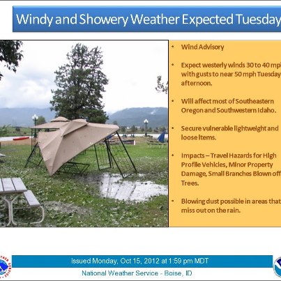
- Strong Winds and Fire Weather Concerns for the North-Central U.S.
High Wind Watches and Warnings are in effect for a large portion of the northern and central Rockies and northern Great Plains. Sustained wind speeds of 25-40 mph, with gus...ts topping 65 mph, could cause blowing dust, localized power outages, and quickly spreading wildfires. The Upper-Midwest and Great Lakes will also see strong winds later this week as the cold front located over the north central portion of the U.S. pushes eastward.See More
http://www.wrh.noaa.gov/FXC/wxstory.php?wfo=byz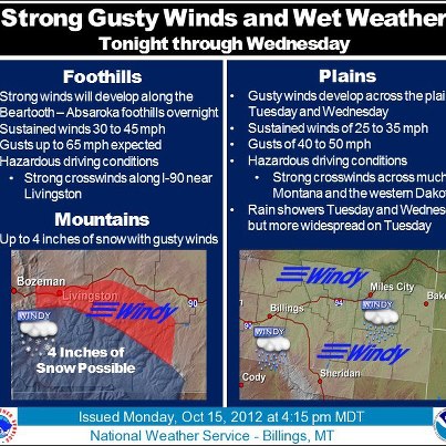
- Rafael is now the 9th Hurricane of the 2012 Atlantic Season. The storm is moving away from the U.S.
For the latest information, please visit: http://www.nhc.noaa.gov/graphics_at2.shtml?5-daynl#contents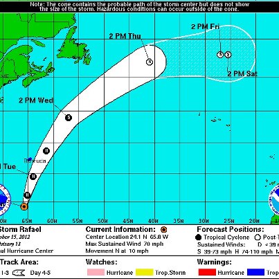
- NOAA Administrator Dr. Lubchenco, Sen. Mikulski and others were on hand to cut the ribbon today at the NOAA Center for Weather and Climate Prediction in College Park, Md. The new building houses the nation’s experts who provide the United States with the best ocean and atmospheric forecasts, including outlooks for the four seasons and hurricanes. Read more...
http://1.usa.gov/R6TBhl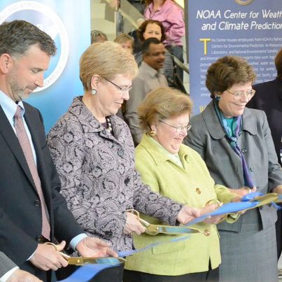
- Today, in College Park, Md., Department of Commerce Acting Secretary Rebecca Blank, NOAA Administrator Dr. Jane Lubchenco, our own Laura Furgione and members of Congress will cut the ribbon on a brand new NOAA facility. Read more about the building and the scientists and work it houses here:
http://1.usa.gov/R6TBhl
(Photo: University of Maryland)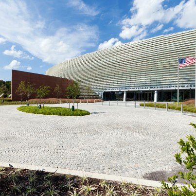
- Severe Weather Possible for Parts of Mid-Atlantic
The NWS Storm Prediction Center is forecasting the possibility of severe thunderstorms Monday afternoon and evening across parts of the Mid-Atlantic, from South Carolina to southern Maryland. The primary risk is damaging wind, though large hail is also possible. Details...
http://go.usa.gov/Rvk
- ...Tropical Storm Rafael Moving Away from Leeward Islands...
Tropical Storm Rafael continues to slowly strengthen as it moves to the north-northwest at 10 mph away from the Caribbean, after bringing some minor flooding issues to some of th...e Leeward Islands. Rafael currently has maximum sustained winds of 65 mph and is forecast to become a minimal Hurricane on Monday. Rafael could bring Tropical Storm conditions to the island of Bermuda as it heads northward and a Tropical Storm Watch is in effect for the island.See More
http://www.nhc.noaa.gov/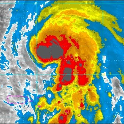
- The NOAA Center for Weather and Climate Prediction is a candidate for silver certification by the U.S. Green Building Council’s LEED™ Green Building Rating System. It was built using materials with recycled and local content, and highly eff...icient glass. Sunshades have been incorporated into the design on the south side of the building to optimize energy performance. Two-thirds of the roof surface is “green roof” covered with low growing plants for better insulation and protection. Rainwater bio-retention areas and a storm water cistern collect water for irrigation, and a four-story rainwater waterfall efficiently drains the non-green roof.See More
Details...
http://1.usa.gov/Q9xoxr
(Photo: University of Maryland)
- ...Severe Weather Possible Today in the Ohio and Tennessee River Valleys...
A strong storm system moving across the central U.S. will bring a threat for severe weather to portions of the Ohio and Tennessee Valleys today. Damaging winds are...the main threat. Winds will be strong even outside the thunderstorms, and several Wind Advisories are in effect for this region. Also, this system will bring heavy rain and possible flash flooding to portions of Michigan.See More
Details...
http://www.hpc.ncep.noaa.gov/discussions/hpcdiscussions.php?disc=pmdspd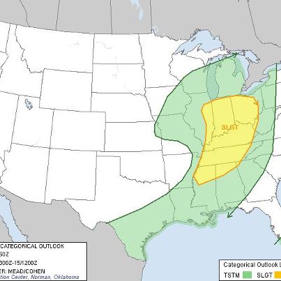
- ...Strong Storm System Brings Flooding Threat to Northern Michigan...
Aside from widespread severe weather and flash flooding in the Southern/Central Plains this weekend, a strong storm system is also bringing a flooding threat to areas of...See More
Central and Northern Michigan. Rains across the area today brought 1 to 2 inches of rain to the area. A second round of rain tomorrow is forecast to bring an additional 1 to 2 and a half inches of rainfall. This could lead to a sharp rise in river and stream levels resulting in some flooding concerns. A flood watch is in effect for the area through Sunday night.
http://go.usa.gov/Y9SP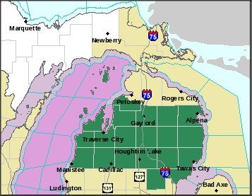
- Construction on the NOAA Center for Weather and Climate Prediction began in 2006, and now it houses about 800 scientists committed to advancing the frontiers of environmental intelligence. Check out the whole process from construction to completion in this slideshow:
http://www.nws.noaa.gov/com/weatherreadynation/news/101212_prediction.html
(Photo: University of Maryland)
- ...Tropical Storm Watch for Puerto Rico...
Tropical Storm Rafael is slowly strengthening over the Northeastern Caribbean Sea. Rafael is forecast to be near or over the U.S. Virgin Islands this evening, and near eastern Puerto Rico overnigh...t into Sunday. A Tropical Storm Warning is in effect for the U.S. Virgin Islands, and a Tropical Storm Watch is in effect for Puerto Rico.See More
Details...
http://www.nhc.noaa.gov/graphics_at2.shtml?5-daynl%3Flarge#contents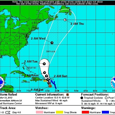
- ...Tropical Storm Rafael Forms in the Caribbean Sea...
As of 8pm, an area of low pressure near the Lesser Antilles has formed Tropical Storm Rafael. The system currently has maximum sustained winds of 40 mph and some slow strengthening is...possible this weekend. Tropical Storm Watches and Warnings are in effect, including a Tropical Storm Watch for Puerto Rico. Rafael is the 17th named storm of this hurricane season.See More
http://go.usa.gov/Y9FY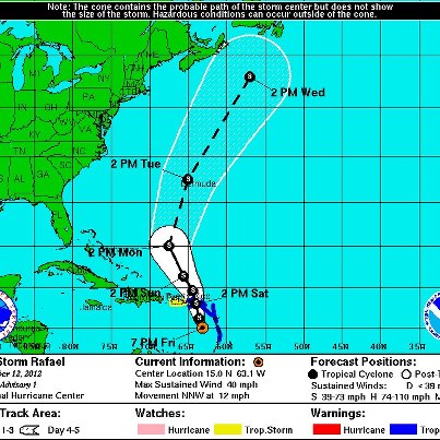
- ...Temperatures to Fall Below Freezing Tonight for much of the Northeast...
Frost Advisories and Freeze Warnings are in effect this evening from the Mid-Atlantic into New England as the coldest temperatures of the season so far are forecas...t to occur. Overnight lows are expected to reach as low as the lower 20s across the mountainous areas of Central NY and temperatures below freezing are forecast from the Virginia's all the way up to Maine.See More
http://go.usa.gov/Y96m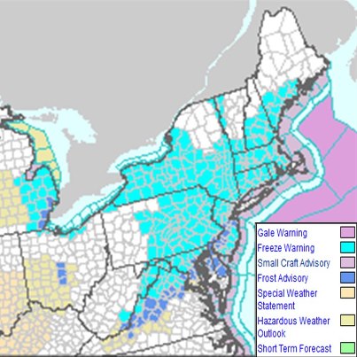
- The NWS Storm Prediction Center has updated its severe weather outlook for Saturday slightly. The Forecast Categorical Severe Weather Outlook for Saturday remains at Slight Risk, though the area of highest risk has been shifted southward sl...ightly in this forecast update. Some of the cities most at risk include: Kansas City, Wichita, Oklahoma City and Tulsa. The total population within the updated Slight Risk area is 36 million. Details...See More
http://www.spc.ncep.noaa.gov/products/outlook/day2otlk.html
This is a very complex situation with considerable forecast uncertainty. Please monitor your local NWS forecast office, NOAA Weather Radio or local media for the latest information, including any warnings that may be issued.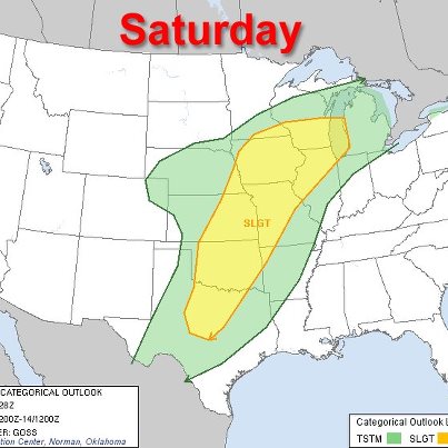
- Heavy Snow is forecast for the central Rockies today into Saturday. Total accumulations of 4 to 8 inches, with wind gusts up to 45 mph, will be common in the high terrain. Heavier amounts of over a foot, with 55 mph wind gusts, are possible...for the Snowy and Sierra Madre Ranges, creating white-out conditions. Travel in the high terrain will be impacted. Details...See More
NWS Denver/Boulder, Colo.
http://www.crh.noaa.gov/ bou
NWS Grand Junction, Colo.
http://www.crh.noaa.gov/gjt/
NWS Pueblo, Colo.
http://www.crh.noaa.gov/pub/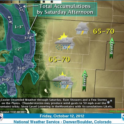
- AOL recently did a four part series on Innovation at NWS. The series captures many of our Weather-Ready Nation efforts and accomplishments over the past year. Check it out...
http://gov.aol.com/tag/innovation+at+NWS/
Below are versions of...the videos in the stories that can display captions...See More
http://youtu.be/9pp3JJNcZfE
http://youtu.be/HXWPltFHRAA
http://youtu.be/GrCPSRZqLwQ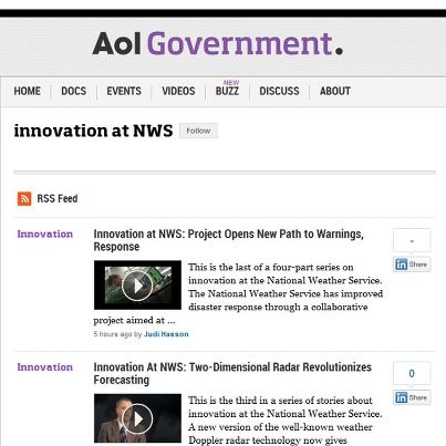
- On Monday, we’re cutting the ribbon at the brand new NOAA Center for Weather and Climate Prediction. The beautiful building is one thing, but it’s the work that will go on inside that will really move us forward to a Weather-Ready Nation. Learn more here:
http://www.nws.noaa.gov/com/weatherreadynation/files/1pgr_NCWCP.pdf
- The NWS Storm Prediction Center is forecasting a risk of severe weather Friday afternoon into the overnight hours that will be a prelude to what could be one of the most active weather weekends of 2012.
On Friday, there is a risk for sever...e thunderstorms across parts of the central and southern Plains — particularly from southwest Kansas to West Texas — as well as the Four Corners region. The primary threats will be large hail, damaging winds and isolated tornadoes.See More
On Saturday, the area at risk for severe weather expands considerably to include parts of 10 states: Nebraska, Kansas, Oklahoma, Texas, Arkansas, Missouri, Illinois, Iowa, Minnesota and Wisconsin. Conditions on Saturday are favorable for supercell thunderstorm capable of producing large hail and damaging winds. A tornado threat may also occur with the better organized supercells. Details...
SPC Day 1 Outlook:
http://www.spc.ncep.noaa.gov/products/outlook/day1otlk.html
SPC Day 2 Outlook:
http://www.spc.ncep.noaa.gov/products/outlook/day2otlk.html
Please monitor your local NWS forecast office, NOAA Weather Radio or local media for the latest information, including any warnings that may be issued.
The areas outlined in yellow in the graphic below show the areas at risk for severe thunderstorms today and tomorrow.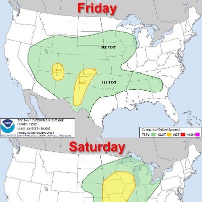
- Tropical Storm Patty Named Near the Bahamas
Tropical Storm Patty is currently located about 225 miles northeast of the Central Bahamas. Sustained winds of 40mph have been reported with this system, which is currently stationary. This storm will begin to very slowly move off to the southwest tonight. Tropical Storm Patty is forecast to be a short lived system.
http://www.nhc.noaa.gov/graphics_at1.shtml?5-daynl#contents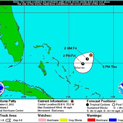
- The NWS Storm Prediction Center is forecasting a risk of severe thunderstorms this afternoon and evening for parts of the central and southern Plains eastward into the Mississippi Valley. The areas at risk include parts of southeastern Kans...as, northeastern Oklahoma, southern Missouri and northern Arkansas. The primary risk will be large hail.See More
The severe weather risk shifts on Friday to the central and southern Plains, from the Texas Panhandle to south-central Nebraska. On Saturday there is a potential for a severe weather outbreak from north-central Texas to southeastern Minnesota and southern Wisconsin. Details...
SPC Day 1 Outlook:
http://www.spc.ncep.noaa.gov/products/outlook/day1otlk.html
SPC Day 2 Outlook:
http://www.spc.ncep.noaa.gov/products/outlook/day2otlk.html
SPC Day 3 Outlook:
http://www.spc.ncep.noaa.gov/products/outlook/day3otlk.html
The areas outlined in yellow in the graphic below show the areas at risk for severe thunderstorms over the next several days.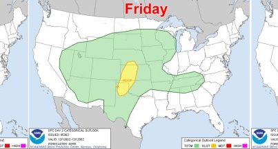
- There’s still time to take part in our annual customer satisfaction survey, which will help us better serve your needs. The survey will take about 20 minutes to complete and need not be finished all at once. We also encourage you to take a moment and complete one or more of the additional sections focused on Hazardous Weather, Marine Weather, and Aviation Weather. Thank you!
http://svy.cfigroup.com/launch/NWS/
- Below-Normal Temperatures Continue Across Eastern Two-Thirds of Nation
High temperatures on Wednesday will be as much as 10-15 degrees below normal for a large portion of the central and eastern U.S., mainly across the Great Lakes, Ohio Va...lley and lower Mississippi Valley. Meanwhile, rain showers are forecast across the western Great Lakes and parts of the Mid-Atlantic. Details...See More
http://go.usa.gov/RRX
The graphic below shows forecast and normal highs for selected cities in the affected area.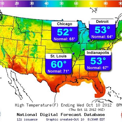
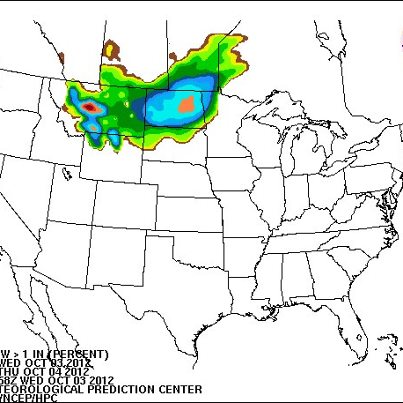
- Scattered Showers Expected Tuesday Across Upper Midwest, Great Lakes
The same weather pattern that has dominated much of the country over the past several days remains in place and will bring a chance of showers on Tuesday along a cold fro...nt extending across the Great Lakes and Upper Midwest. Meanwhile, temperatures will remain below normal across much of the eastern two-thirds of the nation. Details...See More
http://go.usa.gov/RRX
The graphic below shows the 24-hour precipitation forecast through 8 AM EDT Wednesday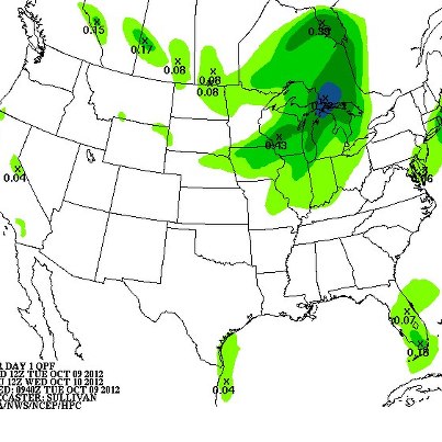
- ...Cold Night in Store for the Ohio Valley...
Temperatures will dip below freezing across much of the Ohio Valley Monday night into Tuesday morning. This will be the first freeze of the season for many in this region. Some crops and sensitive vegetation will be killed by these temperatures. Freeze Warnings and Frost Advisories are in effect.
http://forecast.weather.gov/wwamap/wwatxtget.php?cwa=pbz&wwa=freeze+warning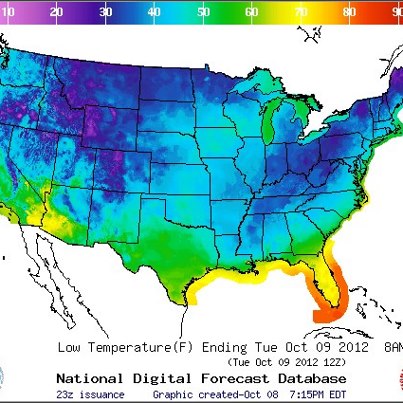
- ...National Hurricane Center Monitoring Two Lows in the Atlantic...
The NHC is currently monitoring two disturbances in the Atlantic Ocean, though neither one is showing significant signs of organization.
The first is showers and thunde...rstorms associated with a trough of low pressure over the Bahamas. Upper level winds are forecast to be unfavorable for tropical development and the NHC only gives a 10% chance for a Tropical Cyclone to form.See More
The other disturbance is a tropical wave in the Central Atlantic. This system is also disorganized and NHC give it a 10% chance of development as well but will be monitored as if moves westward. Details...
http://go.usa.gov/YWmk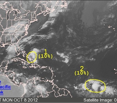
- ...Snow falls in New England Mountains...
The storm system that brought cold temperatures to much of the county this weekend passed through New England overnight, bringing snows to the mountains of Vermont and New Hampshire. Up to 3 and a...half inches of snow was recorded in some of the higher elevations.See More
Graphic displays still shot from the Mount Washington Observatory Observation Deck from this morning. Details...
http://go.usa.gov/YWUJ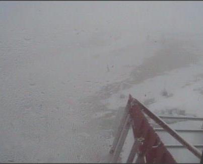
- ...Freeze Warnings and Frost Advisories in Effect Tonight from the Southern Plains to the Northeast United States...
Temperatures tonight will drop into the upper 20s to middle 30s across the southern Great Plains into the Ohio Valley and ...portions of the northeast United States. Several hours of sub-freezing conditions will bring an end to the growing season for the Ohio Valley as well as eastern Oklahoma and southwest Missouri. It is encouraged to move pets and sensitive plants indoors.See More
Graphic depicts where NWS Freeze Warnings and Frost Advisories are in effect Sunday night through Monday morning.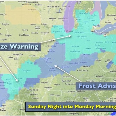
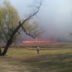
- ...Critical Fire Weather Conditions Likely on Monday...
Warm temperatures will return to portions of eastern Nebraska, western and central Iowa and south central Minnesota on Monday, leading to relative humidities in the upper teens to mid...dle 20s. Winds will strengthen into the 20 to 25 mph range by afternoon, with higher gusts up to 40 mph likely. Given the severe to exceptional drought and the presence of dry fuels across the region, coupled with strong winds and low humidities, critical fire weather conditions are expected to develop on Monday afternoon. Several NWS Weather Forecast Offices have already posted Fire Weather Watches across this region.See More
Graphic depicts the Day 2 Fire Weather Outlook from the NWS Storm Prediction Center.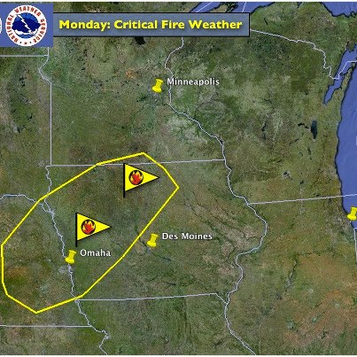
- ...Slight Risk for Severe Storms Along Carolina Coast Today...
The strong cold front that's spread cold temperatures across the U.S. this weekend is moving off the East Coast today. As it heads off the coast, it's bringing a slight chance...of severe thunderstorms to the coastal areas of the North and South Carolina. South of the front, enough instability is forecast for some severe storms to develop this afternoon with damaging straight line winds the main threat, along with hail. Details...See More
http://go.usa.gov/YW9k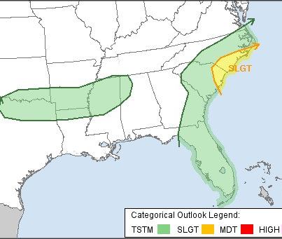
- ...Freeze and Hard Freeze Warnings in Effect Tonight from the Central/Southern Plains to the Upper Great Lakes...
Temperatures tonight will drop into the teens to the lower 30s across the central and southern Great Plains into the Upper Gr...eat Lakes region in the wake of a strong cold front. Several hours of sub-freezing conditions will bring an end to the growing season. It is encouraged to move pets and sensitive plants indoors.See More
Graphic depicts where NWS Hard Freeze Warnings, Freeze Warnings and Frost Advisories are in effect Saturday night through Sunday morning.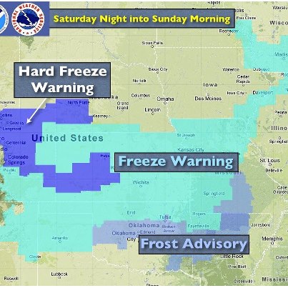
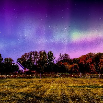
- ...Fall Foliage Putting on a Show in Northern US...
In portions of the Northern U.S. including New England and the Upper Midwest, fall foliage is at or near its vibrant peak. The date of peak foliage varies depending on weather each year ...but generally falls between late September and early November for much of the nation. Just how colorful the leaves become depends on the weather as well, with the brightest colors coming after a wet growing season followed by a dry Autumn with lots of sun and cool, but not freezing, nights. Factors such as drought, or an early hard freeze can lead to poor Fall color.See More
http://www.noaa.gov/features/02_monitoring/foliage.html
- Much Colder Air in Store for Much of U.S. Heading into Weekend
A strong cold front moving across the country will allow a cold air mass to plunge southward from Canada over the next several days, bringing with it below-normal temperatures that will spread eastward from the northern Plains to the East Coast by Sunday. Forecast highs will be in the 40s and 50s across much of the northern Plains and Rockies on Friday, with highs in the 50s extending to the Appalachians on Saturday and the Mid-Atlantic and Northeast on Sunday. Details...
http://go.usa.gov/RRX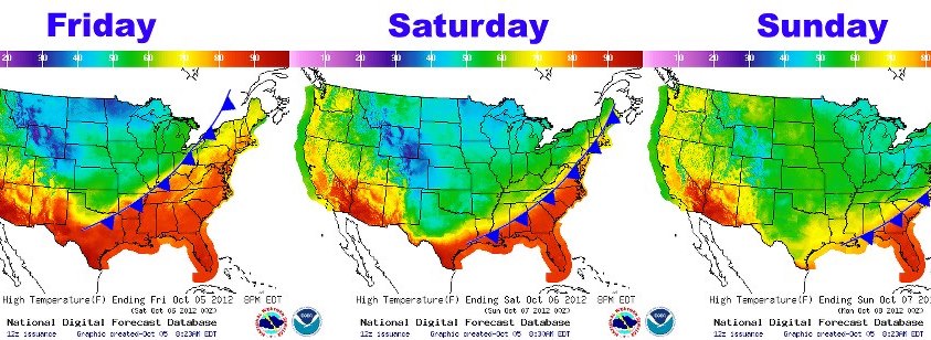
- ...Coldest Air of the New Season Plunging into the Plains...
A powerful cold front will continue to dramatically change the weather for much of the northern and central states through this weekend. This cold Canadian air will bring a hard ...freeze as far south as the Central Plains by Saturday morning, marking the end of the growing season. The cold front will eventually push through the remainder of the Plains to the East Coast and drop temperatures to well below average this weekend.See More
Details...
http://www.hpc.ncep.noaa.gov/discussions/hpcdiscussions.php?disc=pmdspd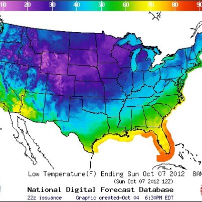
U.S. National Weather Service shared a link.
El Niño or Nada?
An El Niño watch remains in effect, but NOAA climate experts today downgraded the likelihood that it will develop from about 70 percent to 55 percent. Even though its development has slowed, El Niño may still emerge over t...he fall and winter. If it does, it's expected to be a mild one.See More
How can El Niño affect winter weather?
http://www.cpc.ncep.noaa.gov/products/analysis_monitoring/ensocycle/nawinter.shtml
Current El Niño conditions and analyses
http://www.cpc.ncep.noaa.gov/products/precip/CWlink/MJO/enso.shtml- The NWS forecast office in Little Rock, Ark. — which serves more than 1.6 million people in 45 Arkansas counties — has upgraded its Doppler radar with dual polarization technology. The new technology is the most significant enhancement made...to the nation’s radar network since Doppler radar was first installed more than 20 years ago.See More
Forecasters will use the new radar data to improve weather forecasts for rain, winter storms, floods and tornadoes. Ultimately, this upgrade is one more step in our efforts to build a Weather-Ready Nation. Enhanced confidence in weather forecasts will improve public response to weather warnings and improve readiness.
To mark this milestone in the dual pol upgrade, Senator Mark Pryor announced the new technology at the NWS office in Little Rock. Learn more...
Press Release from Sen. Mark Pryor:
http://1.usa.gov/PWFriG
NWS Little Rock:
http://www.srh.noaa.gov/lzk/
Photos from the event:
http://on.fb.me/OEgD1R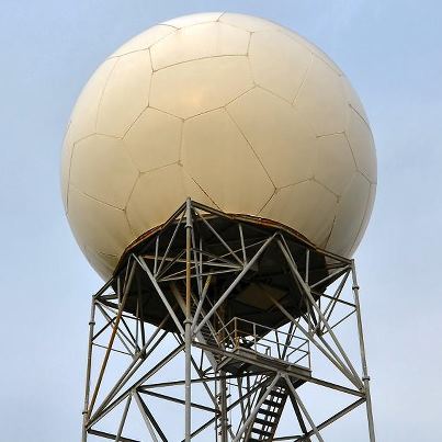
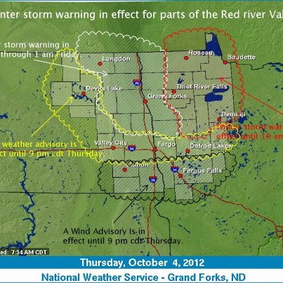
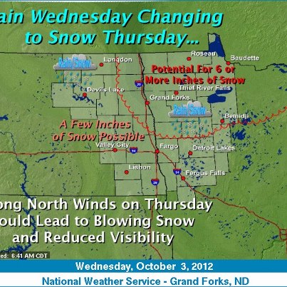
- Early-Season Winter Storm Bringing Snow, Gusty Winds to Northern Minnesota
An early-season winter storm is intensifying as it moves across the Upper Midst. The storm is expected to bring snowfall across parts of northern Minnesota on Thurs...day, with accumulations of 6-12 inches possible. Winter Storm Warnings and Advisories are in effect for northeastern North Dakota and northwestern Minnesota. The storm is expected to move into Canada Thursday night. Details...See More
http://go.usa.gov/RRX
The Weather Story graphic below is from the NWS Grand Forks, N.D., forecast office.