The coming of spring brings many simple pleasures: warming temperatures, the return of wildlife, longer days, and more opportunity to get outdoors. Unfortunately, spring often brings an increased risk of flooding in areas around the country. The rainy months of March and April, combined with melting snow packs, can cause water levels to rise in rivers and streams in many areas.
The cities of Moorhead, Minnesota and Fargo, North Dakota have historically been hit hard by flooding of the Red River, especially with the activity of the last two years. With the National Weather Service calling for another busy flood season along the Red River, we’ve been getting the word out, along with our local and state partners, to make sure residents are taking steps to be prepared for spring flooding.
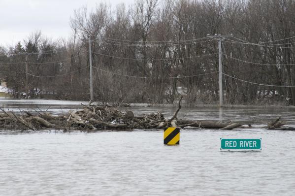
Moorhead, MN, April 4, 2009 -- The Red River drowns the roadway and completely covers over a bridge just north of Moorhead, MN. According to local officials, the 2009 spring flood of the river was the highest ever recorded.
See the recent stories in KSTP (Minneapolis and St. Paul, MN) and the Associated Press, highlighting the National Weather Service forecasts and preparedness messages from local officials.
While flooding along the Red River has been in the headlines recently, flooding can happen in every U.S. state and territory. In particular, the risk of flooding is higher if you are in a low-lying area, near water or downstream from a dam or where the surrounding geography has been changed by development.
As warmer weather approaches, there are simple steps you can take to prepare for seasonal winter flooding:
- Make a plan – Your family may not be together when a flood hits, so it's important to know how you will contact one another, how you will meet up in a safe place and what you will do in case of an emergency. Not sure where to start? Ready.gov has a great checklist for making your family emergency plan.
- Get a kit – An emergency kit can be your life line after an emergency. It should sustain yourself and your family for up to three days. For flood prone areas, keeping your important documents in a sealed, airtight container will keep them safe from water damage. See other tips on getting your emergency kit in tip-top shape.
- Know your risk – One of the most important steps of being prepared is to find out if your home is at risk for flooding. After you know you risk, check out this tool to estimate the financial impact a flood could have your home.
- Protect your property – A final step to make sure you’re prepared for flooding is to purchase flood insurance. Unfortunately, most homeowners insurance does not cover flood damage. Talk to your insurance provider about your policy and consider flood insurance coverage.
** Flood policies typically take 30 days to become effective, so make sure to purchase flood insurance as a way to prepare before potential flooding. **
What steps have you or your community taken to reduce the impact of flooding? Leave a comment below and share your success stories.
- Tim
Some of the most amazing work in recent years related to the Red River of the North flooding events that pertains to the preparedness, response, recovery, and mitigation phases of the emergency management lifecycle, has been that state and many of its localities exceptional work implementing the U.S. National Grid (USNG) (http://www.fgdc.gov/usng) for their GIS and mapping.
ReplyDeleteIn fact, through their state-wide efforts the Emergency Preparedness Committee and it’s chair, Mr. Stephen Swazee (http://www.mngeo.state.mn.us/committee/emprep/index.html), received the Minnesota Governor's Commendation award for GIS in 2010 (http://www.mngeo.state.mn.us/awards/gov_commendations/10commaward.html).
Moreover, both the State of Minnesota and Dakota County, Minnesota, worked with FEMA on sharing their experience by briefing the FEMA staff that teaches the Integrated Emergency Management Course (IEMC) at the National Emergency Training Center (NETC), on their work for the Red River floods and the power of truly integrated emergency management where all assets are using a common operating grid and universal/unified language of location (often to supplement street addressing).
Readers of this comment can also benefit from the State of Minnesota and Dakota County’s (http://www.co.dakota.mn.us/DoingBusiness/MapsAndServices/FreeMaps/neighborhood_maps.htm) efforts, who along with the State of Florida (http://www.floridadisaster.org/gis/USNG/), Delta State University (http://mississippi.deltastate.edu/), the National Search and Rescue Committee (NSARC) (http://www.uscg.mil/hq/cg5/cg534/nsarc/Georeferencing_info.asp), and others, together provided the US Fire Administration and the Emergency Management Institute with a USNG Demonstration Map of the NETC (http://www.usfa.dhs.gov/downloads/pdf/campus_map_usng.pdf PDF, 327 Kb) that can be easily used as a basic training tool, one that includes the NSARC Georeferencing Matrix (with key footnotes, http://www.uscg.mil/hq/cg5/cg534/nsarc/CIS_georef_matrix.doc); and, an Intro to Standards-Based Geospatial Information Technologies (GIT) and the USNG (http://www.usfa.dhs.gov/downloads/pdf/git_usng_intro.pdf PDF, 675 Kb) that includes (from Florida) a model one page USNG appendix for any state-wide emergency response plan. Read that one page appendix. It is short, simple, common sense, and an exceptionally easy baseline capability to train responders and the general public alike.
Excellent posting. You’re beyond doubt an expert of such writing topics. This is absolutely the first time I went through your post and to tell the truth it succeeds in making me visit here time and again.
ReplyDeleteI like the comment about get a kit. We all know it is a good idea to have several days food on hand, but like myself, I have a safe and lock our important documents in it, but when a flood hits everything in there will be ruined. I think I will not only get a fire proof safe, but also make sure it is water-proofed too.
ReplyDeletegreat post, in time lie this people should be extra alert i like the simple steps on how we can take to prepare for seasonal winter flooding...be ready on this we can never tell when it strikes like what happened in japan that was so shocking.
ReplyDeleteGreat post! I live on the red river as well so we are about to face a situation up here in Winnipeg, Manitoba this spring.
ReplyDeleteTime to get out the sandbags .... :)
Also, we tend to have quite an issue with water damage in our basement when the flooding happens.
I found a great guide for taking care of this here: <a href="http://www.fixwaterdamageguide.com/>Fix Water Damage</a>
Cheers,
Kyle
Information is great and certainly understandable. Please carry on to write more on this subject.
ReplyDeleteI like your post cause you are talking about my favorite spring. I like spring so much and I did enjoy you post so much
ReplyDelete