USGS - science for a changing world
Logo and link to The National Map

The National Map


Skip Links

Topographic mapping timeline      The National Map << US Topo Home << Topo History Home
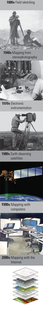
125 Years of Topographic Mapping

U.S. Geological Survey: a History of the National Program for Topographic Mapping (1884–2009) and Continuing Innovation into the Future.

  • Topographic maps became a signature product of the USGS because the public found them — then and now — to be a critical and versatile tool for viewing the nation's vast landscape.
  • From the 1880's until the advent of computers and geographic information system (GIS) software, topographic maps served as the essential instrument for the integration and analysis of place-based information.
  • In the last quarter-century, advancing technologies have transformed topographic mapping science from the printed product to digital data and on-line based applications.
  • Along with highlighting a legacy of 125 years of topographic mapping, the National Geospatial Program of the USGS is proud to release a new type of digital topographic map and the new interactive viewer for The National Map.

History of the Topographic Branch History of the Topographic Branch (Division)
A history of topographic mapping at USGS from the late 1800s to the middle of the nineteenth century.


A 125 Year History of Topographic Mapping A 125 Year History of Topographic Mapping and GIS
in the U.S. Geological Survey 1884-2009, Part 1
1884-1980


A 125 Year History of Topographic Mapping A 125 Year History of Topographic Mapping and GIS
in the U.S. Geological Survey 1884-2009, Part 2
1980-2009


Historical Mapping Photographs - Mapping the West Historical Mapping Photographs - Mapping the West
A collection of historical USGS mapping photographs.


A Celebration of 125 Years of Topographic Mapping A Celebration of 125 Years of Topographic Mapping
The U.S. Geological Survey is celebrating the 125th anniversary of its national program for topographic mapping (1884–2009).


 Free document viewers: Adobe Reader | Microsoft Word | Microsoft Excel | Microsoft Powerpoint
 

Accessibility FOIA Privacy Policies and Notices

Take Pride in America logo USA.gov logo U.S. Department of the Interior | U.S. Geological Survey
URL: http://nationalmap.gov/ustopo/history.html
Page Contact Information: US Topo
Page Last Modified: Monday, 14-Jan-2013 17:53:43 EST