

|
|
|
Fact Sheet
The Geographic Information System for Breast Cancer Studies on Long Island (LI GIS) is a unique research tool combining an extensive collection of data and other geospatial resources. The LI GIS is designed primarily to study potential relationships between environmental exposures and breast cancer in Nassau and Suffolk counties (Long Island), NY; however, its application can be extended to the study of other diseases. Researchers with approved protocols can access the LI GIS datasets online; there is no fee to use the LI GIS.
About the LI GIS Data 
This unique research tool has more than 80 in-depth, high-quality datasets that primarily cover the 1990s but also cover several previous decades. Breast cancer is a disease of long latency, and data from years ago are especially useful to researchers. The LI GIS incorporates:
- Topographic data, including locations of roads, water features, parks and landmarks, and base maps that define legal boundaries and serve as reference points;
- Demographic data, including the age, race, sex, and income of the population;
- Health outcome data, including relative breast cancer incidence and health facilities data;
- Environmental data, including land use and cover; railroads; traffic; water use and potential sources of water pollution; chemical releases into water, air, and soil; electric power lines; information on toxic chemicals and hazardous and municipal waste; and radiation; and
- Data with less detail and geographic precision for areas within 31 miles of the two Long Island counties, and very limited data for areas within a 100-mile radius from the midpoint of the boundary line between the two counties. The extended area includes counties in Connecticut, New Jersey, New York, Pennsylvania, Rhode Island, and Massachusetts.
More details about the information contained in the LI GIS datasets can be found in the Metadata Browser that can be accessed at http://li-gis.cancer.gov/metadata/metadata.html.
The LI GIS in Action
The LI GIS contains an extensive database for exploration. It has an interactive base map that displays relative breast cancer incidence by ZIP Code, on which users can overlay relevant exposure data. For example, data can be displayed on inactive and active hazardous waste sites and on exposure to pesticides, insecticides, fungicides, and herbicides across different water systems. This interactive capability enables users to visualize disease rates and clusters and spatiotemporal trends, and to examine possible relationships between exposures coinciding with disease incidence.
Additionally, the LI GIS database can be explored and analyzed using standard GIS software incorporating statistical, geostatistical, and geospatial tools to:
- Develop and test research hypotheses (i.e., statistical relationships),
- Model the extent of potential exposures to various environmental and social conditions that may be relevant to understanding disease risk, and
- Model spatiotemporal trends in disease rates and exposures.
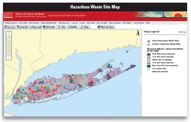
This map pinpoints New York State inactive and active hazardous waste sites for 1980–1995 that are overlaid on a map showing relative breast cancer incidence (observed/expected) by ZIP Code. Sources: New York State Department of Environmental Conservation and New York State Department of Health Cancer Surveillance Improvement Project
The LI GIS was developed as part of the Long Island Breast Cancer Study Project (LIBCSP), a congressionally mandated activity to understand breast cancer incidence rates on Long Island. Visit the LI GIS Web site to learn more and to obtain application materials: http://li-gis.cancer.gov. Access other information about the ways in which NCI makes use of GIS technology at http://gis.cancer.gov.
Contact: Deborah M. Winn, Ph.D.
Co-Project Officer
E-mail: winnde@mail.nih.gov
