|
|
|
What Is a Geographic Information System (GIS)?
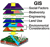
 A geographic information system (GIS) integrates hardware, software, and data for capturing, managing, analyzing, and displaying information with a geographic component. Almost all data has some sort of geographic component associated with it, such as a country, city, address, or latitude and longitude lines.
To learn more about GIS:
- Visit NCI's Geographic Information Systems Web site, a central source of information about GIS and related resources with information on ways in which the National Cancer Institute makes use of GIS technology.
- The Centers for Disease Control and Prevention (CDC) offers information about public health applications of GIS technology, through the National Center for Health Statistics (NCHS).

