NOAA home United States Department of Commerce
DOC home
NOAA home National Oceanic and Atmospheric Administration
DOC home
NOAA and DOC logos
Current Conditions

NOAAWatch

NOAA's All Hazard Monitor
Local forecast by City, State
 

Weather Warnings

Weather Warnings Map of the United States

Doppler Radar

Doppler Radar Map of the United States

River and Lake Levels

River and Lake Leverls

NOAA Environmental Visualization Laboratory

NOAA Environmental Visualization Laboratory Image of the Day

Drought Outlook

Drought Outlook Map of the United States
U.S. Drought Monitor - Current Drough Conditions

Surface Weather Charts

Unified Surface Analysis of World Oceans


Daily Forecast Map Archive

Archive of daily weather forecast maps - Jan 3, 2001 to Present


La Niña / El Niño Index

El-Nino / La Nina Meter at plus 0.1 signifying a sea surface temperature anomoly of plus 0.1 degrees C. - Click for Outlook
Updated Feb 5, 2013

Sea surface temperature (°C) departure from normal

El Niño/ENSO - Impacts
FAQ

Today's UV Index
Forecast Map

UV Index


Daily Maximum
Heat Index Maps

Daily Maximum Heat Index Maps
Heat Index Chart
Health Effects of Extreme Heat

International Disaster Reports

Severe Weather Information Centre
World Meteorological Organization
Provided by World Meteorological Organization

Global Disaster Alert and Coordination System

Asian Disaster Reduction Center (ADRC) Disaster Information

GLobal IDEntifier Number (GLIDE)


Weather Outlook for Thursday

Thu, 14 Feb 2013 07:19:00 EST
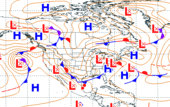
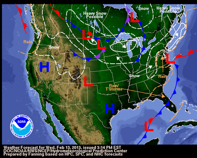
Light snows skirting the southern New England coast should come to an end Thursday morning as a quick moving coastal storm pushes farther out to sea. The tail end of the storm's cold-front, however, will stall over southern Florida and keep weather unsettled across the sunshine state. Weak energy aloft, moving through the northern Gulf of Mexico and towards the southeastern U.S. should help enhance precipitation along the stalled boundary, leading to periods of moderate to heavy rains, with embedded thunderstorms over the southern tip of Florida. Light snow showers are expected from the Dakotas to the Great Lakes. Latest local weather forecasts, warnings, watches, and advisories...

Hydrometeorological Prediction Center Short Range Forecast Discussion

learn more about drought Drought monitor map

Rains Ease Drought Across the Country

Fri, 08 Feb 2013 07:25:57 EST
Drought eased slightly in parts of the country from Hawaii to Virginia, intensified in other areas, and was nearly unchanged over the hardest-hit areas of the Plains, in the week that ended Feb. 5, according to the U.S. Drought Monitor. A powerful storm Jan. 29 and 30 brought much-needed precipitation to the Southeast and to parts of the South and southern Plains. Precipitation eased drought in some parts of the Midwest, particularly in areas where soils were not frozen and moisture could seep into the ground. Snowpack improved in some areas but is still below normal in much of the West. All Hawaiian islands have seen some improvement in drought after two weeks of good rain. Some states saw drought ease in some areas but intensify in others. Drought eased in western Colorado but intensified in the eastern part of the state, while in Oklahoma, drought intensified in the Panhandle but eased to the east. Details...


Earthquake Information from the U.S. Geological Survey
Learn more about earthquakes from NOAAWatch U.S. Geological Service

M 5.8, Tonga

Fri, 15 Feb 2013 03:02:23 GMT
February 15, 2013 03:02:23 GMT Details...

Latest Earthquakes - Last 7 Days

NOAA NewsNews from NOAA
Contiguous United States warmer and wetter than average for January
Thu, 14 Feb 2013 13:10:00 -0500
According to NOAA scientists, the average temperature for the contiguous U.S. during January was 32.0°F, 1.6°F above the 20th century average, tying with 1958 as the 39th warmest January on record. Drought conditions remained entrenched across the Southeast, Great Plains, and the mountainous West. Details...


NOAAWatch & Learn
Explore NOAAWatch themes:
air quality

Air Quality

coral

Coral Bleaching

Droughts

Droughts

earthquake

Earthquakes

excessive heat

Excessive Heat

fire

Fire Weather

Flooding

Flooding

habs

Harmful Algal Blooms(HABs)

tropical

Hurricanes/Tropical Weather

coastal inundation

Storm Surge & Coastal Floods

Oil and Chemical Spills

Oil & Chemical Spills

Rip Currents

Rip Currents

lightning bolt

Severe Weather

Space weather

Space Weather

wave

Tsunamis

volcano

Volcanoes

snow

Winter Weather

UV Index

Ultraviolet (UV) Radiation


NOAAWatch
Archive


NOAA Weather Radio
Stay informed 24/7 with the NOAA All Hazards Weather radio.


Ocean News Logo
Updates from trusted sources for ocean news


Preparedness Resources

· Ready America - DHS
· Plan Ahead - FEMA
· Preparedness for    People With Disabilities
· HHS - Disasters &    Emergencies
· American Red Cross
· DisasterAssistance.gov


Ask NOAA a question
Ask NOAA a question... or find an answer in our database!


Daily Briefing

Comprehensive Briefing Materials


NOAA Homeland Security Program Office


RSS Feeds RSS Feeds


USA.gov is the U.S. government's official web portal to all federal, state and local government web resources and services.