| |
||||||
|
||||||
Article |
|
| The Public Land Survey System (PLSS) | |
|
|
|
| What is the PLSS? | |
| The Public Land Survey
System (PLSS) is a way of subdividing and describing land in the United
States. All lands in the public domain are subject to subdivision
by this rectangular system of surveys, which is regulated by the U.S.
Department of the Interior, Bureau
of Land Management (BLM).
The PLSS typically divides land into 6-mile-square townships, which is the level of information included in the National Atlas. Townships are subdivided into 36 one-mile- square sections. Sections can be further subdivided into quarter sections, quarter-quarter sections, or irregular government lots. Normally, a permanent monument, or marker, is placed at each section corner. Monuments are also placed at quarter-section corners and at other important points, such as the corners of government lots. Today permanent monuments are usually inscribed tablets set on iron rods or in concrete. The original PLSS surveys were often marked by wooden stakes or posts, marked trees, pits, or piles of rock, or other less-permanent markers. The PLSS actually consists of a series of separate surveys. Most PLSS surveys begin at an initial point, and townships are surveyed north, south, east, and west from that point. The north-south line that runs through the initial point is a true meridian and is called the Principal Meridian. There are 37 Principal Meridians, each is named, and these names are used to distinguish the various surveys. The east-west line that runs through the initial point is called a base line. This line is perpendicular to the Principal Meridian. |
|
 Source: Principal Meridians and Base Lines, Bureau of Land Management |
|
| Each township is identified with a township and range designation. Township designations indicate the location north or south of the baseline, and range designations indicate the location east or west of the Principal Meridian. For example, a township might be identified as Township 7 North, Range 2 West, which would mean that it was in the 7th tier of townships north of a baseline, and in the 2nd column of townships west of a principal meridian. A legal land description of a section includes the State, Principal Meridian name, Township and Range designations with directions, and the section number: Nebraska, Sixth Principal Meridian T7N, R2W, sec5. | |
 |
|
|
While the original PLSS surveys were supposed to conform to official procedures, some errors were made due either to honest mistakes or to fraudulent surveys. Existing surveys are considered authoritative, and any new surveys must work from existing corners and surveys, in spite of errors in the original surveys and variations from the ideal. This sometimes results in sections that are far from square, or that contain well over or under 640 acres. The early surveys in Ohio and Indiana were done when the system currently in use had not yet been fully developed. While these surveys have townships that are 6 miles square, the numbering system used and the types of starting points for the surveys are different from those used elsewhere in the United States. These surveys are also named, although the names are not based on Principal Meridians. Further information on these irregular surveys can be found in the references listed at the end of this article. In particular, see the Background Information on the Public Land Survey System. |
|
 Source: Principal Meridians and Base Lines, Bureau of Land Management |
|
| In Louisiana, parcels of land known as arpent sections or French arpent land grants also pre-date the PLSS, but are treated as PLSS sections. An arpent is a French measurement of approximately 192 feet, and a square arpent (also referred to as an arpent) is about 0.84 acres. French arpent land divisions are long narrow parcels of land usually found along the navigable streams of southern Louisiana, and also found along major waterways in other areas. This system of land subdivision was begun by French settlers in the 1700s, according to typical French practice at the time and was continued by both the Spanish and by the American government after the acquisition of the Louisiana Purchase. A typical French arpent land division is 2 to 4 arpents wide along the river by 40 to 60 arpents deep, while the Spanish arpent land divisions tend to be 6 to 8 arpents wide by 40 arpents deep. This method of land division provided each land-owner with river frontage as well as land suitable for cultivation and habitation. These areas are given numbers just like standard sections, although the section numbers frequently exceed the normal upper limit of 36. | |
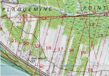 French arpent land division influence in Louisiana. Source: U.S. Geological Survey |
|
| back
to top |
|
| History | |
| Originally proposed
by Thomas Jefferson, the PLSS began shortly after the Revolutionary
War, when the Federal government became responsible for large areas
west of the thirteen original colonies. The government wished both
to distribute land to Revolutionary War soldiers in reward for their
service, as well as to sell land as a way of raising money for the
nation. Before this could happen, the land needed to be surveyed.
The Land Ordinance of 1785 which provided for the systematic survey and monumentation of public domain lands, and the Northwest Ordinance of 1787 which established a rectangular survey system designed to facilitate the transfer of Federal lands to private citizens, were the beginning of the PLSS. Under Congressional mandate, cadastral surveys (surveys of the boundaries of land parcels) of public lands were undertaken to create parcels suitable for disposal by the Government. The extension of the rectangular system of surveys over the public domain has been in progress since 1785, and, where it applies, the PLSS forms the basis for most land transfers and ownership today. The Manual of Instructions for the Survey of the Public Lands Of The United States, 1973 documents current official procedures for PLSS surveys. Certain lands were excluded from the public domain and were not subject to survey and disposal. These lands include the beds of navigable bodies of water, national installations such as military reservations and national parks, and areas such as land grants that had already passed to private ownership prior to subdivision by the Government. France, Spain, and Mexico all conferred land grants in territory they claimed; many of these grants were confirmed by the U.S Government when the territory in which they were situated was acquired by the United States, and the land was then excluded from the public domain. Over the past two centuries, almost 1.5 billion acres have been surveyed into townships and sections. The BLM is the Federal Government's official record keeper for over 200 years' worth of cadastral survey records and plats. In addition, BLM is still completing numerous new surveys each year, mostly in Alaska, as well as conducting resurveys to restore obliterated or lost original survey corners. |
|
| back
to top |
|
| Commonly Used Terms | |
| Aliquot part—The
standard subdivisions of a section, such as a half section, quarter
section, or quarter-quarter section.
Base line—A parallel of latitude, or approximately a parallel of latitude, running through an arbitrary point chosen as the starting point for all sectionalized land within a given area. Cadastral—Having to do with the boundaries of land parcels. Government lot—A subpart of a section which is not described as an aliquot part of the section, but which is designated by number, for example, Lot 3. A lot may be regular or irregular in shape, and its acreage may vary from that of regular aliquot parts. These lots frequently border water areas excluded from the PLSS. Initial point—The starting point for a survey. Land Grant—A land grant is an area of land to which title was conferred by a predecessor government and confirmed by the U.S Government after the territory in which it is situated was acquired by the United States. These lands were never part of the original public domain and were not subject to subdivision by the PLSS. Principal meridian—A meridian line running through an arbitrary point chosen as a starting point for all sectionalized land within a given area. Public domain—Land owned by the Federal
government for the benefit of the citizens. The original public
domain included the lands that were turned over to the Federal Government
by the Colonial States and the areas acquired later from the native
Indians or foreign powers. Sometimes used interchangeably with Public
lands. |
|
| back
to top |
|
| Related Links | |
|
|
ReferencesFederal Land Policy and Management Act of 1976, As Amended Land Survey Information System
|
|
| back
to top |

