Geoenabling Federal Business Processes
This article was originally published in the Summer 2010 issue of Esri's Federal GIS Connections newsletter. 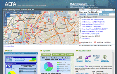
Citizens want to know about the quality of the air and water in their communities, what types of toxins they may be exposed to, and what adverse environmental factors may be present near homes they are considering purchasing. While the answers to these questions would The MyEnvironment application developed by the EPA links directly to relevant data sources and present the information in several formats, such as maps, reports, and charts. seem to require extensive research across numerous sources, the Environmental Protection Agency (EPA) uses geospatial technology to deliver this information through a single, easyto- use online interface called MyEnvironment. This application provides location-specific maps, reports, and charts on environmental conditions from numerous federal, state, local, and private sources.
MyEnvironment is just one of many examples of federal organizations geospatially enabling their business operations to better accomplish mission goals. Geoenabled innovations throughout the federal government have helped agencies streamline mission-critical functions, saving resources and improving results while empowering individuals to learn about issues facing their communities. Federal geospatial applications and crossagency initiatives such as the Geospatial Line of Business (LOB) leverage geographic information system (GIS) technology to reduce the cost of government programs; inform decision making; and, at the same time, improve services to citizens. The Geospatial Line of Business' Geo-Enabled Business Work Group brings together federal agency representatives who volunteer their time to assist federal program managers and executives in identifying their geoenabled business needs, capabilities, and opportunities.
Consolidating Information
A key characteristic of GIS technology is its ability to bring assorted information together. Many agencies leverage GIS to combine data from disparate sources to serve specific, mission-oriented goals. For example, NOAA created nowCOAST, a geoenabled Web site that provides access to real-time coastal data. This site brings together georeferenced information from numerous federal agencies, NOAA's internal resources, and 15,000 external sources. For NOAA, GIS created value by enabling an integrated, authoritative, Web-based source for information on coastal conditions that is easily accessible for the public, commercial purposes, and federal users. The USDA Farm Service Agency (FSA) consolidated information through its Common Land Unit (CLU) dataset, a comprehensive digital dataset that includes millions of farmland boundaries obtained from paper maps in more than 2,300 offices. CLU helps FSA more effectively carry out mission-critical functions, including compliance and conservation, by combining digital farm boundaries with business data.
Improving and Streamlining Operations The Tool for Environmental Resource Results Assessment (TERRA) program, also created by the USDA FSA, combines 27 formerly independent calculations and pieces of information into one geoenabled application. TERRA helps FSA weigh the costs and benefits of renting land from farmers to stop soil erosion—a mission-critical function that is part of the Conservation Reserve Program. Both farmers and staff members use this database to quickly visualize areas of protected land. Calculations that may have taken days in the past now take only minutes.
Another example of streamlining processes is the National Institute of Justice (NIJ) Mapping and Analysis for Public Safety (MAPS) program at the Department of Justice (DOJ). Through the MAPS program, NIJ created a range of geospatial tools that focus on mapping incidents of crime to better inform police investigations and actions. MAPS improves the ability of law enforcement professionals to fight crime while providing resources for crime researchers.
Increasing Sharing and Interagency Coordination
In addition to time and cost savings, many organizations use geospatial technology to facilitate inter- and intra-agency coordination. Enterprise Geospatial Services (EGS) facilitates spatial data sharing throughout FEMA by actively managing data collection, storage, and use. EGS also facilitates data sharing between offices within FEMA and with other agencies, which curbs the tendency to create information silos within a branch or section. The Bureau of Land Management developed the National Integrated Land System (NILS) GeoCommunicator to coordinate geographic data from numerous groups, furthering cooperation among offices and assisting in land-use decision making. Additionally, EPA Metadata Editor (EME) fosters increased sharing of geospatial resources through better quality metadata. The coordination and sharing of information reduces redundancy, provides decision makers with better access to higher-quality information, and encourages agencies to coordinate their efforts to solve complex problems.
Automating and Improving Adherence to Standards
As agencies work together, adhering to standards becomes increasingly important. The U.S. Department of Housing and Urban Development (HUD) developed the Geocode Service Center (GSC) to confirm the accuracy of address information for more than 17 data systems, ensuring data consistency across HUD programs and serving as a model for other agencies.
Providing GIS Toolkits and Suites of Services
Many federal agencies provide value to their users by developing easy-to-access toolkits or suites of services. DOJ's MAPS, for example, provides law enforcement professionals and researchers with a desktop-based geospatial crime analysis kit, complete with profiling utilities, a crime analysis extension, and more. In addition, NIJ provides Web-based crime tracking and prevention tools. FEMA also provides a variety of geospatial services to its users, including professional services such as geospatial project management, technical training, and systems engineering.
Including Stakeholder Outreach and Input
Many agencies recognize the crucial role The National Integrated Land System GeoCommunicator, developed by the Bureau of Land Management, coordinates geographic data from internal, federal, and state agencies and tribal and local entities. that stakeholders have in creating and implementing a successful geospatial project. For example, while creating the CLU database, designers consulted FSA staff from offices around the country, key decision makers, and even farmers to create a tool that would assist in capturing CLU data and performing the functions that FSA needed. NOAA, EPA, and USGS have included stakeholders throughout collaborative design and implementation. Expanding GIS technology in a way that realizes the best value for the government and the public is critical to creating a sustainable, geoenabled future. For more information on the Geospatial LoB and its structure, visit www.fgdc.gov/geospatial-lob/factsheets.