Geospatial Platform News Release
Federal Geographic Data Committee Launches New Geospatial Website
Posted 11/09/2011
State-of-the-art platform has tools for the public to create maps, share information
11/09/2011
Contact: Adam Fetcher, (DOI) 202-208-6416
Ivan DeLoatch, (USGS) 703-648-5752
WASHINGTON, D.C.—The federal government and its geospatial partners today unveiled www.geoplatform.gov, a prototype Geospatial Platform website providing an initial view of the future of user-friendly, integrated, federal data collections on common geographic maps.
This prototype version of the Geospatial Platform combines map-based data and tools with the latest internet technologies to deliver geospatial information in a simple, understandable package. Users—including the public, federal agencies and their partners—can easily find federally-maintained geospatial data, services and applications, as well as access data from our partners across State, Tribal, Regional and local governments.
"The Geospatial Platform will provide a user-friendly ‘one-stop shop’ for place-based data you can trust, and the tools to display that data on a map platform," said Anne Castle, Assistant Secretary of the Interior for Water and Science.
Through the website, users can create their own maps by combining their data with public domain data and can collaborate in public and private groups with others who share their interests. Maps assembled through the Geospatial Platform can be shared with others through web browsers and mobile technologies. All of this is possible without requiring users to install software on their own computers.
The Geospatial Platform has been developed as a partnership among the member agencies of the Federal Geographic Data Committee (FGDC), an interagency committee composed of representatives from the Executive Office of the President,...
Read MoreGeospatial Platform Conference Presentation Available for Download
Posted 09/09/2011
The Geospatial Platform team gave a presentation at the Esri International User Conference (IUC) last July. Proceedings from the IUC are now available for download from Esri's website. To access the Geospatial Platform presentation, you can search the proceedings for "geospatial platform," or download a PDF of the presentation. 
Topics covered in the presentation include:
-
Geospatial Platform Implementation
-
Future Platform Plans
-
Implementation of Federal Geospatial Portfolio Management
-
Importance of OMB A-16 Supplemental Guidance
-
NGDA Theme Development
Read More
Roadmap for the Geospatial Platform is Released
Posted 05/02/2011
The final version of the Modernization Roadmap for the Geospatial Platform is now available for download. 
This final version of the Roadmap follows a stakeholder engagement process intended to share the vision for the Platform and gather feedback from the geospatial community regarding concepts discussed in the Roadmap. Feedback on the Roadmap to date has been positive, while at the same time identifying some challenging issues and questions that will be addressed as implementation occurs.
Developing the Roadmap has been an evolving process that began in February 2010 with the release of the President's 2011 Budget, which provided initial direction to develop the Geospatial Platform. An earlier draft Roadmap (version 3), was approved by the Office of Management and Budget (OMB) on November 10, 2010. That document, prepared by member agencies of the Federal Geographic Data Committee (FGDC), received broad Federal review and upon OMB approval set the stage for a more robust stakeholder engagement process.
The geospatial community at large has been engaged in providing feedback on the Roadmap over the past several months.Version 4 of the Roadmap attempts to incorporate ideas and feedback that result in a more clear presentation and description of the ideas contained in the Roadmap. As implementation of the Geospatial Platform occurs, components (or ?pillars) that appear independent in the Roadmap will become more closely interrelated, providing a dynamic environment that will continue to grow and change as information is gathered, the offering is developed...
Read MoreGeospatial Platform Featured at Esri International User Conference
Posted 05/02/2011
The Geospatial Platform team will present at the Esri International User Conference, to be held July 11-15, 2011 in San Diego, CA. To learn more about the Geospatial Platform and meet our team, please stop by the FGDC booth or attend the Geospatial Platform presentation session:![]()
Session Title: Building the Geospatial Platform and Related FGDC Initiatives (1.5 hrs)
This interactive session will provide an update on the current status and next steps for the Geospatial Platform. A summary of related Federal Geographic Data Committee (FGDC) activities will also be presented in order to describe key linkages between interagency projects. This session will specifically focus on recent progress made on Geospatial Platform technologies, federal geospatial portfolio management, and platform governance. It will also include updates from key Geospatial Platform partners, such as the National Geospatial Advisory Committee (NGAC).
Please check back soon for this session's date and time.
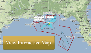
Read MoreMapping the Response to BP Oil Spill in the Gulf of Mexico
Posted 03/14/2011
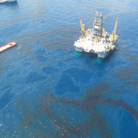
The Environmental Response Management Application (ERMA®) Gulf Response is an online mapping tool that provides you with up-to-date information about the spill response effort in the Gulf of Mexico. Developed by NOAA with the U.S. EPA, Coast Guard, and the Department of Interior, this site offers a visual and centralized means of accessing spill response information. It represents the federal government's commitment to providing clear and transparent information on the 2010 Deepwater Horizon/BP oil spill.
The tool integrates the latest response data related to the oil spill, such as scientific samples and information on wildlife and other Gulf Coast resources into one customizable, interactive map. ERMA Gulf Response also integrates real-time information such as weather conditions, tide and currents, and vessel locations.
ERMA Gulf Response is the public version of ERMA developed by NOAA and the University of New Hampshire's Coastal Response Research Center. ERMA was designed to facilitate communication and coordination among a variety of users—from federal, state, and local responders to local community leaders and the public. Click the map below to use the tool yourself and see both current and historical data about the oil spill, as well as shipping information, past fishery closures, and locations where responders are still working.
USING THIS TOOL
- After clicking on the interactive map...