Follow this link to skip to the main content NASA Jet Propulsion Laboratory California Institute of Technology JPL HOME EARTH SOLAR SYSTEM STARS & GALAXIES SCIENCE & TECHNOLOGY BRING THE UNIVERSE TO YOU JPL Email News RSS Mobile Video
JPL Banner
Mars Science Laboratory
Home
MISSION
Eyes and Other Senses

The rover's "eyes" and other "senses"

The rover has seventeen "eyes." Six engineering cameras aid in rover navigation and four cameras perform science investigations.

Each camera has an application-specific set of optics:


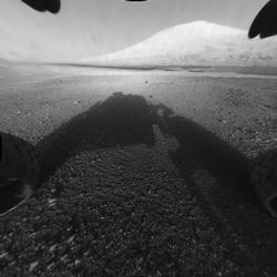
Behold Mount Sharp!
Behold Mount Sharp!
The image was captured by the rover's front left Hazard-Avoidance camera at full resolution shortly after it landed. It has been linearized to remove the distorted appearance that results from its fisheye lens.

Four Pairs of Engineering Hazard Avoidance Cameras (Hazcams):


Mounted on the lower portion of the front and rear of the rover, these black-and-white cameras use visible light to capture three-dimensional (3-D) imagery. This imagery safeguards against the rover getting lost or inadvertently crashing into unexpected obstacles, and works in tandem with software that allows the rover make its own safety choices and to "think on its own."

The cameras each have a wide field of view of about 120 degrees. The rover uses pairs of Hazcam images to map out the shape of the terrain as far as 3 meters (10 feet) in front of it, in a "wedge" shape that is over 4 meters wide (13 feet) at the farthest distance. The cameras need to see far to either side because unlike human eyes, the Hazcam cameras cannot move independently; they are mounted directly to the rover body.

Two Pairs of Engineering Navigation Cameras (Navcams):


Mounted on the mast (the rover "neck and head"), these black-and-white cameras use visible light to gather panoramic, three-dimensional (3D) imagery. The navigation camera unit is a stereo pair of cameras, each with a 45-degree field of view that will support ground navigation planning by scientists and engineers. They work in cooperation with the hazard avoidance cameras by providing a complementary view of the terrain.

Four Science Cameras: MastCam (one pair), ChemCam, MAHLI:

Mast Camera will take color images, three-dimensional stereo images, and color video footage of the martian terrain and have a powerful zoom lens.

Like the cameras on the Mars Exploration Rovers that landed on the red planet in 2004, the MastCam design consists of two duplicate camera systems mounted on a mast extending upward from the Mars Science Laboratory rover deck. The cameras function much like human eyes, producing three-dimensional stereo images by combining two side-by-side images taken from slightly different positions.

The Laser-Induced Remote Sensing for Chemistry and Micro-Imaging will fire a laser and analyze the elemental composition of vaporized materials from areas smaller than 1 millimeter on the surface of Martian rocks and soils. An on-board spectrograph will provide unprecedented detail about minerals and microstructures in rocks by measuring the composition of the resulting plasma - an extremely hot gas made of free-floating ions and electrons.

The Mars Hand Lens Imager is the equivalent of a geologist's hand lens and will provide close-up views of the minerals, textures and structures in martian rocks and the surface layer of rocky debris and dust. With this new device, earthbound geologists will be able to see martian features smaller than the diameter of a human hair.

One Descent Imager--MARDI:

Engineers who worked on the Mars Exploration Rover mission were able to get an idea of what the approaching martian terrain "looked" like to Spirit and Opportunity via DIMES (Descent Image Motion Estimation System). This system was used to detect the spacecraft's movement and adjust it - using retro rockets - if necessary. Mars Science Laboratory features an even more capable visual system. MARDI (Mars Descent Imager) provided four frame-per-second video at a high resolution during Curiosity's landing. The images are "true color," or as the human eye would see.

In addition to stunning video, the data the camera collects will allow scientists and engineers to: observe geological processes at a variety of scales, sample the horizontal wind profile, create detailed geologic, geomorphic and traverse planning and relief maps of the landing site.


USA.gov
PRIVACY     FAQ     SITEMAP     FEEDBACK     IMAGE POLICY