
The launch of the National Broadband Map marks the beginning of a promising new venture: empowering consumers, researchers, policy-makers, and developers to truly understand what broadband means in America. When the map went live yesterday, the response was astounding, with the number of requests to the website averaging more than 1,000 per second! Below is just a short list of the metrics we observed on our first day; This phenomenal response shows that the investment of time, energy, and — not least of all — Congressional funds were well worth it. The National Broadband Map clearly has a market of interest, and we’re extremely proud to see that market being well served. With this kind of traffic, we are tripling efforts to serve you better. The team has been working round the clock to make infrastructure enhancements to the site. These enhancements include horizontal scaling of servers, adding more memory and more caching to the maps, tuning the map server architecture with the software developers for the map, and working with outside partners to help with the application. We are also working to resolve known browser issues with the map. Most features of the website can be viewed in any browser, but the maps in the gallery are best viewed with Firefox and Chrome. You can help identify and solve these issues through feedback. I can’t wait to keep making the National Broadband Map better, particularly because I know that feedback, new ideas, and innovation around the map will be driving that process.
This idea — a powerful way to navigate huge troves of data to increase transparency and understanding — drove the production of the map. In building the map, our team had a hunch that there would be a hunger for a tool that served up this level of detail and information. The talented designers, web architects, and geospatial pros kept that in mind throughout the entire building process.
[Cross-posted from the National Broadband Map Blog.]
Archive for February 2011
First 24 hours
February 22nd, 2011 by Michael Byrne - Geographic Information OfficerThe National Broadband Map
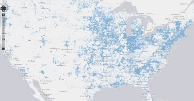
February 18th, 2011 by Anne Neville - Director, State Broadband Initiative – NTIAWelcome to the first-ever public, searchable nationwide map of broadband access.
The National Broadband Map is an unprecedented project created by NTIA, in collaboration with the FCC, and in partnership with each state, territory and the District of Columbia. We created the map at the direction of Congress, which recognized that economic opportunities are driven by access to 21st Century infrastructure.
With funding from NTIA’s State Broadband Data & Development Program, our state partners have gathered and worked to validate broadband data from thousands of providers across the country. Together, we developed a dataset and website that includes more than 25 million searchable records displaying where broadband Internet service is available, the technology used to provide the service, the maximum advertised speeds of the service, and the names of the broadband providers. Whether you are a consumer seeking more information on the broadband options available to you, a researcher or policymaker working to spur greater broadband deployment, a local official aiming to attract investment in your community, or an application developer with innovative ideas, the National Broadband Map can help. And if you don’t find the answer you’re looking for on the map itself, you can download the entire dataset.
While the launch of this map is a huge accomplishment, today is just the beginning. Our partners in the states are working to expand and update this important dataset, and we will update the map with new data every six months. In the meantime, you can help. Each time you search the map, you have the opportunity to tell us about the data you’re seeing. This crowdsourced feedback will be an important tool to improve and refine the data.
We invite you to explore the many features and functionalities the National Broadband Map offers. To start, search for broadband by address. Or go straight to our analysis tools and compare one area to others, and make sure you spend some time with our maps. Want more? Download the dataset, use our APIs and please tell us how you’re using the data.
We expect the map will be a valuable tool as we work to bridge the technological divide, expand economic opportunities, and leverage the power of broadband to address many of the nation’s most pressing challenges. We hope you will make full use of its capabilities and let us know what you think and how we can improve.
Modernizing and Streamlining the Universal Service Fund
February 7th, 2011 by Haley Van Dÿck - FCC New MediaThis morning, Chairman Genachowski laid out a proposal to get broadband to rural America while cutting waste and inefficiency in two of the Commission's largest programs.
Universal service has been core to the FCC's mission since the Communications Act of 1934 created the agency and committed our nation to making vital communications services accessible to all. The Universal Service Fund helped connect virtually every American to our 20th century communications grid. But this program, along with Commission's closely related Intercarrier Compensation rules, have become riddled with waste and inefficiency and are not up to our nation's broadband challenge. Today, up to 24 million Americans have no access to broadband;fixed or mobile.
At tomorrow's meeting, the Commission will vote on the proposal to transform the Universal Service Fund and Intercarrier Compensation rules from programs designed to support 20th Century voice networks to a force for expansion of 21st century fixed and mobile broadband and voice networks, while eliminating waste and inefficiency.
Broadban, Education, and The Learning Registry
February 4th, 2011 by Ellen SatterwhiteThis week, a report on teachers’ media usage, sponsored in part by PBS, offers new evidence to support the National Broadband Plan's finding that broadband has greater potential to transform education than any other technological innovation in our lifetime. The report talks about the incredible increases in teachers' use of digital content in their teaching—not just layering technology on top of lessons, but digitally transforming their classrooms. The survey found, for example:
- Three in four teachers (76%) stream or download TV and video content, up from 55% in 2007. These teachers are also accessing content in completely new ways, with 24% reporting that they access content stored on a local server, up from 11% in 2007.
- Teachers view TV and video content as more effective for student learning when integrated with other instructional resources or content. More than two-thirds (67%) believe that digital resources help them differentiate learning for individual students, and a similar number (68%) believe TV and video content stimulates discussion.
