
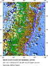
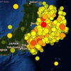
Magnitude 9.0 - NEAR THE EAST COAST OF HONSHU, JAPAN
2011 March 11 05:46:24 UTC
Earthquake Details
- This event has been reviewed by a seismologist.
| Magnitude | 9.0 |
|---|---|
| Date-Time |
|
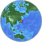
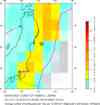
| Location | 38.297°N, 142.372°E |
| Depth | 30 km (18.6 miles) set by location program |
| Region | NEAR THE EAST COAST OF HONSHU, JAPAN |
| Distances | 129 km (80 miles) E of Sendai, Honshu, Japan 177 km (109 miles) E of Yamagata, Honshu, Japan 177 km (109 miles) ENE of Fukushima, Honshu, Japan 373 km (231 miles) NE of TOKYO, Japan |
| Location Uncertainty | horizontal +/- 13.5 km (8.4 miles); depth fixed by location program |
| Parameters | NST=350, Nph=351, Dmin=416.3 km, Rmss=0.1 sec, Gp= 29°, M-type=centroid moment magnitude (Mw), Version=A |
| Source |
|
| Event ID | usc0001xgp |
- Press Release: USGS Updates Magnitude of Japan's 2011 Tohoku Earthquake to 9.0Mon, 14 Mar 2011 17:35:00 EDT
- Did you feel it? Report shaking and damage at your location. You can also view a map displaying accumulated data from your report and others.
Earthquake Summary

Felt Reports
At least 15,703 people killed, 4,647 missing, 5,314 injured,
130,927 displaced and at least 332,395 buildings, 2,126 roads, 56
bridges and 26 railways destroyed or damaged by the earthquake and
tsunami along the entire east coast of Honshu from Chiba to
Aomori. The majority of casualties and damage occurred in Iwate,
Miyagi and Fukushima from a Pacific-wide tsunami with a maximum
runup height of 37.88 m at Miyako. The total economic loss in
Japan was estimated at 309 billion US dollars. Electricity, gas
and water supplies, telecommunications and railway service
disrupted and several reactors severely damaged at a nuclear power
plant near Okuma. Several fires occurred in Chiba and Miyagi. At
least 1,800 houses destroyed when a dam failed in Fukushima.
Maximum acceleration of 2.93 g recorded at Tsukidate. Horizontal
displacement and subsidence observed. Landslides occurred in
Miyagi. Liquefaction observed at Chiba, Odaiba, Tokyo and Urayasu.
The tsunami destroyed or severely damaged many coastal towns in
the Kuji-Minamisanriku-Nami area. One person killed and several
houses destroyed at Jayapura, Indonesia by a tsunami with a wave
height of 2 m. One person killed south of Crescent City,
California and several boats and docks destroyed or damaged at
Crescent City by a tsunami with a recorded wave height of 247 cm.
Several houses, boats and docks destroyed or damaged at Santa
Cruz, California; Brookings, Oregon; Hale`iwa, Kailua Kona and
Kealakekua, Hawaii. Some buildings damaged slightly in the
Galapagos Islands, Ecuador by a tsunami with a recorded wave
height of 208 cm at Santa Cruz. Several houses destroyed at Pisco,
Peru. Several buildings destroyed at Dichato and several boats
damaged at Puerto Viejo and on Isla Chiloe, Chile. Felt (VIII) at
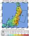
Fukushima, (VII) at Agui, Hiratsuka, Kiryu, Komae, Oyama, Sendai
and Tsukuba and (VI) in much of eastern Honshu, including the
Tokyo-Yokohama area, Japan. Felt from Hokkaido to Kyushu. Recorded
(7 JMA) in Miyagi. Felt in Northern Mariana Islands, North Korea,
South Korea, Taiwan, northeastern China and southeastern Russia as
far as Kaohsiung, Beijing and Petropavlovsk-Kamchatskiy. Seiches
observed at Leikanger, Norway. Water fluctuations observed in a
well in Newfoundland, Canada. The tsunami had maximum runup
heights of 29.6 m at Ofunato, 18.4 m at Onagawa and 9.4 m at
Iwaki.
The tsunami also caused some massive slabs of ice to calve from the
Sulzberger Ice Shelf, Antarctica.
Tectonic Summary
Versión en Español
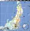
The magnitude 9.0 Tohoku earthquake on March 11, 2011, which occurred near the northeast coast of Honshu, Japan, resulted from thrust faulting on or near the subduction zone plate boundary between the Pacific and North America plates. At the latitude of this earthquake, the Pacific plate moves approximately westwards with respect to the North America plate at a rate of 83 mm/yr, and begins its westward descent beneath Japan at the Japan Trench. Note that some authors divide this region into several microplates that together define the relative motions between the larger Pacific, North America and Eurasia plates; these include the Okhotsk and Amur microplates that are respectively part of North America and Eurasia.
The location, depth, and focal mechanism of the March 11 earthquake are consistent with the event having occurred on the subduction zone plate boundary. Modeling of the rupture of this earthquake indicate that the fault moved upwards of 30-40 m, and slipped over an area approximately 300 km long (along-strike) by 150 km wide (in the down-dip direction). The rupture zone is roughly centered on the earthquake epicenter along-strike, while peak slips were up-dip of the hypocenter, towards the Japan Trench axis. The March 11 earthquake was preceded by a series of large foreshocks over the previous two days, beginning on March 9th with a M 7.2 event approximately 40 km from the epicenter of the March 11 earthquake, and continuing with another three earthquakes greater than M 6 on the same day.
The Japan Trench subduction zone has hosted nine events of magnitude 7 or greater since 1973. The largest of these, a M 7.8 earthquake approximately 260 km to the north of the March 11 epicenter, caused 3 fatalities and almost 700 injuries in December 1994. In June of 1978, a M 7.7 earthquake 35 km to the southwest of the March 11 epicenter caused 22 fatalities and over 400 injuries. Large offshore earthquakes have occurred in the same subduction zone in 1611, 1896 and 1933 that each produced devastating tsunami waves on the Sanriku coast of Pacific NE Japan. That coastline is particularly vulnerable to tsunami waves because it has many deep coastal embayments that amplify tsunami waves and cause great wave inundations. The M 7.6 subduction earthquake of 1896 created tsunami waves as high 38 m and a reported death toll of 27,000. The M 8.6 earthquake of March 2, 1933 produced tsunami waves as high as 29 m on the Sanriku coast and caused more than 3000 fatalities. Unlike the recent magnitude 9.0 earthquake, the 1933 earthquake did not occur as the result of thrust faulting on the subduction-zone plate interface, but rather within the Pacific plate just seaward of the Japan Trench.
The March 11, 2011 earthquake far surpassed other post-1900 plate-boundary thrust-fault earthquakes in the southern Japan Trench, none of which attained M8. A predecessor may have occurred on July 13, 869, when the Sendai area was swept by a large tsunami that Japanese scientists have identified from written records and a sand sheet.
Continuing readjustments of stress and associated aftershocks are expected in the region of this earthquake. The exact location and timing of future aftershocks cannot be specified. Numbers of aftershocks will continue to be highest on and near to fault-segments on which rupture occurred at the time of the main-shock. The frequency of aftershocks will tend to decrease with elapsed time from the time of the main shock, but the general decrease of activity may be punctuated by episodes of higher aftershock activity. Beyond the ongoing aftershock sequence, the USGS does not believe that the earthquakes in Japan have significantly raised the probability of future major earthquakes. While the probability of future large earthquakes far from northern Honshu has not increased, neither has it decreased and large earthquakes will continue to occur just as we have observed in the past.
Earthquake Information for Asia
Earthquake Information for Japan
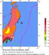
Seismicity of the Earth 1900 to 2007, Japan and Vicinity Map
USGS Audio CoreCast Interview with Seismologists Bill Ellsworth and Eric Geist
Tohoku, Japan M9.0 Educational Slides (PDF version) or (PPT version)
Earthquake Maps
Scientific & Technical Information
 USGS Centroid Moment Tensor Solution
- Global CMT Project Moment Tensor Solution
- USGS WPhase Moment Tensor Solution
- Historic Moment Tensor Solutions
- Finite Fault Model
- Phase Data
- Seismicity Cross Section
- Theoretical P-Wave Travel Times
- BRI Strong Motion Information
- Energy and Broadband Solution
- Japan Earthquake Strong-Motion Data at CESMD
- Subduction Zone Geometry Analysis
- Preliminary Geodetic Slip Model
 Tsunami Information
The earthquake locations and magnitudes cited in NOAA tsunami statements and bulletins are preliminary and are superseded by USGS locations and magnitudes computed using more extensive data sets.
General Tsunami Information
- NOAA West Coast & Alaska Tsunami Warning Center
- NOAA Pacific Tsunami Warning Center
- International Tsunami Information Center
- Tsunami Information Links
- NOAA Tsunami Wave Height Projections image
- IISEE - Intl. Institute for Seismology and Earthquake EngineeringTsunami Info
- Tsunami Basics Video from the International Tsunami Information Center
Additional Information
- Google Crisis Response webpage
- IRIS Resources for Japan Earthquake
- NOAA Animation of Tsunami
- IISEE-Intl. Insitute of Seismology and Earthquake Engineering Special Page
- JMA Report (v1) - Japan Meteorological Agency
- UNAVCO Community Response to the Mw=9.0 Tohoku, Japan Earthquake and Tsunami March 11, 2011
- Person Finder (Google app)
- Preliminary Earthquake Report
- U.S. Geological Survey, National Earthquake Information Center:
World Data Center for Seismology, Denver
