Archive for July, 2012

Dawn Sets Its Sights on Ceres

Monday, July 30th, 2012

By Marc Rayman

As NASA’s Dawn spacecraft investigates its first target, the giant asteroid Vesta, Marc Rayman, Dawn’s chief engineer, shares a monthly update on the mission’s progress.

near-true color image of the remarkable snowman feature on asteroid Vesta's surface
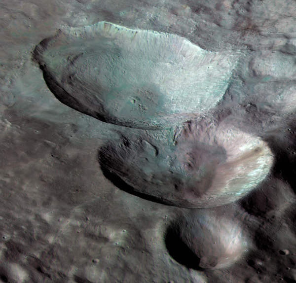
Three impact craters of different sizes, arranged in the shape of a snowman, make up one of the most striking features on Vesta, as seen in this view from NASA’s Dawn mission. In this view the three “snowballs” are upside down, so that the shadows make the features easily recognizable. North is to the lower right in the image, which has a resolution of 230 feet (70 meters) per pixel. Image credit: NASA/JPL-Caltech/UCLA/MPS/DLR/IDA

Dear Dawnpartures,

Dawn has completed the final intensive phase of its extraordinary exploration of Vesta, and it has now begun its gradual departure. Propelled by its uniquely efficient ion propulsion system, the probe is spiraling ever higher, reversing the winding path it followed into orbit last year.

In the previous log (which gained prominence last month by making it into the list of the top 78 logs ever written on this ambitious interplanetary adventure), we saw the plan for mapping Vesta from an altitude of 680 kilometers (420 miles). In this second high-altitude mapping orbit (HAMO2), the spacecraft circled the alien world beneath it every 12.3 hours. On the half of each orbit that it was on the day side, it photographed the dramatic scenery. As it passed over the night side, it beamed the precious pictures to the distant planet where its human controllers (and many of our readers) reside. Tirelessly repeating this strategy while Vesta rotated allowed Dawn’s camera to observe the entirety of the illuminated land every five days.

The robot carried out its complex itinerary flawlessly, completely mapping the surface six times. Four of the maps were made not by pointing the camera straight down at the rocky, battered ground but rather at an angle. Combining the different perspectives of each map, scientists have a rich set of stereo images, allowing a full three dimensional view of the terrain that bears the scars of more than 4.5 billion years in the main asteroid belt between Mars and Jupiter.

Dawn also mapped Vesta six times during the first high-altitude mapping orbit (HAMO1) in September and October 2011. The reason for mapping it again is that Vesta has seasons, and they progress more slowly than on Earth. Now it is almost northern hemisphere spring, so sunlight is finally reaching the high latitudes, which were under an impenetrable cloak of darkness throughout most of Dawn’s residence here.

For most of the two centuries this mysterious orb had been studied from Earth, it was perceived as little more than a small fuzzy blob in the night sky. With the extensive imaging from HAMO1 and HAMO2, as well as from the low-altitude mapping orbit (LAMO, earthlings now know virtually all of the protoplanet’s landscape in exquisite detail.

Among the prizes for the outstanding performance in HAMO2 are more than 4,700 pictures. In addition to the comprehensive mapping, Dawn collected nearly nine million spectra with its visible and infrared mapping spectrometer (VIR) to help scientists determine more about the nature of the minerals. This phenomenal yield is well over twice that of HAMO1, illustrating the great benefit of dedicating valuable observation time in HAMO2 to VIR before the mapping.

Dawn’s measurements of the peaks and valleys, twists and turns of Vesta’s gravity field, from which scientists can map the distribution of material in the interior of the behemoth, were at their best in LAMO. That low altitude also was where the gamma ray and neutron detector (GRaND) obtained its finest data, revealing the atomic constituents of the surface and subsurface. Indeed, the motivation for undertaking the challenging descent to LAMO was for those investigations, although the bonus pictures and spectra greatly enhanced the reward. Even in HAMO2, however, gravity and GRaND studies continued, adding to an already fabulous bounty.

Mission controllers have continued to keep the distant spacecraft very busy, making the most of its limited time at Vesta. Pausing neither to rest nor to marvel or delight in its own spectacular accomplishments, when the robot finished radioing the last of its HAMO2 data to Earth, it promptly devoted its attention to the next task: ion thrusting.

Missions that use conventional propulsion coast almost all of the time, but long-time readers know that Dawn has spent most of its nearly five years in deep space thrusting with its advanced ion propulsion system, the exotic and impressive technology it inherited from NASA’s Deep Space 1. Without ion propulsion, the exploration already accomplished would have been unaffordable for NASA’s Discovery Program and the unique exploit to orbit both Vesta and dwarf planet Ceres would have been quite impossible. Ion propulsion not only enables the spacecraft to orbit residents of the main asteroid belt, something no other probe has attempted, but it also allows the interplanetary spaceship to maneuver extensively while at each destination, thus tailoring the orbits for the different investigations.

On July 25 at 9:45 a.m. PDT, as it has well over 500 times before, the sophisticated craft began emitting a beam of high-velocity xenon ions. In powered flight once again, it is now raising its orbital altitude. On August 26, the ship will be too far and traveling too fast for Vesta’s gravity to maintain its hold. Dawn will slip back into orbit around the sun with its sights set on Ceres.

Although HAMO2 is complete, the spacecraft will suspend thrusting four times to direct its instruments at Vesta during the departure phase, much as it did in the approach phase. The approach pictures aided in navigation and provided tantalizing views of the quarry we had been seeking for so long. This time, however, we will see a familiar world receding rather than an unfamiliar one approaching. But as the sun creeps north, advancing by about three quarters of a degree of latitude per week, the changing illumination around the north pole will continue to expose new features.

› Continue reading Marc Rayman’s Dawn Journal


Slice of History: Remote Controlled Manipulators

Tuesday, July 10th, 2012

By Julie Cooper

Each month in “Slice of History” we feature a historical photo from the JPL Archives. See more historical photos and explore the JPL Archives at https://beacon.jpl.nasa.gov/.

Remote Controlled Manipulators
Remote Controlled Manipulators — Photograph Number 381-4778B

The NASA Jet Propulsion Laboratory’s 1971 Annual Report featured this photo of a remote controlled system for handling solid propellants. A 1965 Space Programs Summary report indicated that the equipment had been ordered and would be installed in building 197 within a few months. This equipment made it possible to safely mix and load high energy solid propellants into small motors. Building 197 is still known as the Solid Propellant Engineering Laboratory.

This post was written for “Historical Photo of the Month,” a blog by Julie Cooper of JPL’s Library and Archives Group.


A Different Slant:

Monday, July 9th, 2012

By Duane Roth

Cassini Has a Special View of Saturn These Days - How Did It Get There?

For the past 18 months, NASA’s Cassini spacecraft has been orbiting Saturn in practically the same plane as the one that slices through the planet’s equator. Beginning with the Titan flyby on May 22, navigators started to tilt Cassini’s orbit in order to obtain a different view of the Saturnian system. The measure of the spacecraft orbit’s tilt relative to Saturn’s equator is referred to as its inclination. The recent Titan flyby raised Cassini’s inclination to nearly 16 degrees. Seven more Titan flybys will ultimately raise Cassini’s inclination to nearly 62 degrees by April 2013. On Earth, an orbit with a 62-degree inclination would pass as far north as Alaska and, at its southernmost point, skirt the latitude containing the tip of the Antarctic Peninsula.

These graphics show the orbits NASA's Cassini spacecraft has made and will make around the Saturn system from September 2010 to April 2013.These graphics show the orbits NASA’s Cassini spacecraft has made and will make around the Saturn system from September 2010 to April 2013. As shown in gray, Cassini orbited within the plane of Saturn’s equator during the first 18 months of its current mission phase, known as the Solstice mission. Then, starting in May 2012, Cassini used the gravity of Saturn’s largest moon, Titan, to tilt its orbit as shown in the magenta loops, reaching a maximum tilt of about 62 degrees in April, 2013. Titan’s orbit is shown in red. The orbits of Saturn’s inner moons are shown in black. Image credit: NASA/JPL-Caltech

You may wonder why this change has been planned and how this feat is achieved. The “why” is to allow scientists to observe Saturn and the rings from different geometries in order to obtain a more comprehensive three-dimensional understanding of the Saturnian system. For instance, because Saturn’s rings lie within Saturn’s equatorial plane, they appear as a thin line when viewed by Cassini in a near-zero-degree orbit inclination. From higher inclinations, however, Cassini can view the broad expanse of the rings, making out details within individual ringlets and helping to unlock the secrets of ring origin and formation. Some of those images have already started to come in.

At higher inclinations, Cassini can also obtain excellent views of Saturn’s poles, and measure Saturn’s atmosphere at higher latitudes via occultation observations, where radio signals, sunlight or starlight received after passing through the atmosphere help to determine its composition and density.

The “how” is by using the gravity of Titan — Saturn’s largest moon by far — to change the spacecraft’s trajectory. Like the rings and Cassini’s previous orbit, Titan revolves around Saturn within a plane very close to Saturn’s equatorial plane. As Cassini flies past Titan, Titan’s gravity bends the spacecraft’s path by pulling it towards the moon’s center — similar to a ball bearing rolling on a smooth horizontal surface past a magnet. Near Titan, the motion is confined to a plane containing the spacecraft’s path and Titan’s center of mass. If this “local” plane coincides with Cassini’s orbital plane about Saturn, the trajectory’s inclination will remain unchanged. However, if this plane differs from Cassini’s orbital plane about Saturn, then the bending from Titan’s gravity will have a component out of Cassini’s orbital plane with Saturn, and this will change the tilt of the spacecraft’s orbit. Repeated Titan flybys will raise Cassini’s orbit inclination to nearly 62 degrees by April of next year and then lower it back to the Saturn equatorial plane in March 2015.

This view, from the imaging camera of NASA's Cassini spacecraft, shows the outer A ring and the F ring of SaturnNASA’s Cassini spacecraft has recently resumed the kind of orbits that allow for spectacular views of Saturn’s rings. This view, from Cassini’s imaging camera, shows the outer A ring and the F ring. The wide gap in the image is the Encke gap, where you see not only the embedded moon Pan but also several kinky, dusty ringlets. A wavy pattern on the inner edge of the Encke gap downstream from Pan and a spiral pattern moving inwards from that edge show Pan’s gravitational influence. The narrow gap close to the outer edge is the Keeler gap. Image credit: NASA/JPL-Caltech/SSI

Gravity assists are key to Cassini’s ever-changing orbital geometries. Onboard propellant alone would quickly become depleted attempting to accomplish these same changes. A gravity assist can be characterized by the amount of “delta-v,” or change in the velocity vector, it imparts to a spacecraft. Delta-v may of course also be imparted to the spacecraft via rocket engines and, either way, alters the spacecraft’s orbit. The eight Titan gravity assists responsible for raising Cassini’s inclination to 62 degrees will provide a delta-v of 15,000 mph (6.6 kilometers per second). For comparison, Cassini’s rocket engines had only enough propellant after initially achieving orbit around Saturn to deliver about 2,700 mph (1.2 kilometers per second) of delta-v. That’s 15,000 mph of capability spread over 11 months via gravity assists versus a modest 2,700 mph of capability spread over more than 13 years via rocket engines! Because delta-v is a vector, it may change both the speed and direction of Cassini at a point along its orbit, so the speed of Cassini is not changing by 15,000 mph, but mostly all of the directional changes sum to 15,000 mph. To give these values some context, Cassini’s speed typically varies between as low as 2,500 mph (1.1 kilometers per second) and as high as 79,000 mph (35 kilometers per second) relative to Saturn between apokrone and perikrone, the farthest and closest points from Saturn along its orbit. Gravity assists from the initial prime mission Titan flyby in 2004 to the final Solstice Mission Titan flyby in 2017 will provide nearly 200,000 mph (90 kilometers per second) of delta-v, leveraging the onboard propellant by a ratio of 75 to 1. The bulk of the Saturn tour trajectory is shaped by gravity assists, while the role of onboard propellant is to fine-tune the trajectory.

At the end of year 2015, Cassini will again begin climbing out of Saturn’s equatorial plane in preparation for its grand finale. After reaching an inclination of nearly 64 degrees, a Titan gravity assist in April 2017 will change Cassini’s perikrone so that Cassini will pass through the narrow 2,000-mile (3,000-kilometer) gap between Saturn’s atmosphere and innermost ring. Twenty-two spectacular orbits later, one final distant Titan gravity assist will alter Cassini’s course for a fiery entry into Saturn’s atmosphere to end the mission.


Shedding Light on the Scarred Face of Asteroid Vesta

Thursday, July 5th, 2012

By Marc Rayman

As NASA’s Dawn spacecraft investigates its first target, the giant asteroid Vesta, Marc Rayman, Dawn’s chief engineer, shares a monthly update on the mission’s progress.

Image of the giant asteroid Vesta taken by NASA's Dawn spacecraft
This image, from NASA’s Dawn spacecraft, shows rock material that has moved across the surface and flowed into a low area in the ridged floor of the Rheasilvia basin on Vesta. The image shows how impacts and their aftermath constantly reshape the landscape. Image credit: NASA/JPL-Caltech/UCLA/MPS/DLR/IDA/PSI

Dear Upside Dawn Readers,

Dawn is now seeing Vesta in a new light. Once again the probe is diligently mapping the ancient protoplanet it has been orbiting for nearly a year. Circling the alien world about twice a day, the ardent adventurer is observing the signatures of Vesta’s tortured history, including the scars accumulated during more than 4.5 billion years in the main asteroid belt between Mars and Jupiter.

Having successfully completed its orbital raising maneuvers to ascend to its second high-altitude mapping orbit (HAMO2), Dawn looks down from about 680 kilometers (420 miles). This is the same height from which it mapped Vesta at the end of September and October 2011. The lifeless rocky landscape has not changed since then, but its appearance to the spacecraft’s sensors has. The first high-altitude mapping orbit (HAMO1) was conducted shortly after southern hemisphere summer began on Vesta, so the sun was well south of the equator. That left the high northern latitudes in the deep darkness of winter night. With its slower progression around the sun than Earth, seasons on Vesta last correspondingly longer. Thanks to Dawn’s capability to linger in orbit, rather than simply conduct a brief reconnaissance as it speeds by on its way to its next destination, the probe now can examine the surface with different lighting.

Much of the terrain that was hidden from the sun, and thus the camera, during HAMO1 is now illuminated. Even the scenery that was visible then is lit from a different angle now, so new observations will reveal many new details. In addition to the seasonal northward shift in the position of the sun, Dawn’s orbit is oriented differently in HAMO2, as described last month, so that makes the opportunity for new insights and discoveries even greater.

The strategy for mapping Vesta is the same in HAMO2 now as it was in HAMO1. Dawn’s orbital path takes it nearly over the north pole. (As we saw last month, the orbit does not go exactly over the poles but rather reaches to 86 degrees latitude. That slight difference is not important for this discussion.) During the ship’s southward passage over the sunlit side, the camera and the visible and infrared mapping spectrometer (VIR) acquire their precious data. After passing (almost) above the south pole, Dawn sails north over the night side. Instead of pointing its sensors at the deep black of the ground below, the probe aims its main antenna to the extremely distant Earth and radios its findings to the exquisitely sensitive receivers of the Deep Space Network. The pattern repeats as the indefatigable spacecraft completes loop after loop after loop around the gigantic asteroid every 12.3 hours.

As Dawn revolves, Vesta rotates on its axis beneath it, turning once every 5.3 hours. Just as in HAMO1, mission planners artfully choreographed this celestial pas de deux so that over the course of 10 orbits, lasting just over five days, the camera would be able to view nearly all of the lit surface. A set of 10 orbits is known to Dawn team members (and to you, loyal readers) as a mapping cycle.

Until a few months ago, HAMO2 was planned to be four cycles. Thanks to the determination in April that Dawn could extend its residence at Vesta and still meet its 2015 appointment with dwarf planet Ceres, HAMO2 has been increased to six mapping cycles (plus even a little more, as we shall see below), promising a yet greater scientific return.

In cycle 1, which began on June 23, the camera was pointed at the surface directly underneath the spacecraft. The same view will be obtained in cycle 6. In cycles 2 through 5, images are acquired at other angles, providing different perspectives on the complex and dramatic landscape. Scientists combine the pictures to formulate topographical maps, revealing Vesta’s full three-dimensional character from precipitous cliffs and towering peaks of enormous mountains to gently rolling plains and areas with mysterious ridges and grooves to vast troughs and craters punched deep into the crust. Knowing the elevations of the myriad features and the angles of slopes is essential to understanding the geological processes and forces that shaped this exotic mini-planet. In addition to the exceptional scientific value, the stereo imagery provides realistic, exciting views for anyone who wants to visualize this faraway world. If you have not traveled there yourself, be sure to visit the Image of the Day regularly and the video gallery occasionally to see what you and the rest of humankind had been missing during the two centuries of Vesta’s appearance being only that of a faint, tiny blob in the night sky.

› Continue reading Marc Rayman’s Dawn Journal