Special Event Imagery Special Event Imagery
2010 - index
Special Event Imagery Special Event Imagery
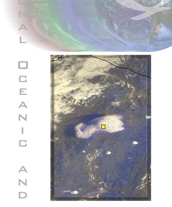
OSEI volcano products include multichannel color composite imagery showing ash clouds (VSH), hotspots from lava flow (VIR) or both (VOL). We also create grayscale "split-window" images which use a channel differencing technique that enhances the appearance of ash clouds in imagery (DIF). This technique is oftenuseful for distinguishing ash clouds from water vapor clouds.

The Washington Volcanic Ash Advisory Center has real time satellite imagery and derived advisory products at:

The following image files have recently been added to the Volcano archive...

National Oceanic and Atmospheric Administration
Location
Directory
Map Link
ChileChile
ColombiaColombia
CongoCongo
MAP
EcuadorEcuador
MAP
GuatemalaGuatemala
MAP
HawaiiHawaii
MAP
IcelandIceland
MAP
IndianOceanIndianOcean
MAP
IndonesiaIndonesia
Italy_StromboliItaly_Stromboli
MAP
JapanJapan
MAP
KamchatkaKamchatka
MAP
MarianasMarianas
MAP
MexicoMexico
MontserratMontserrat
MAP
New ZealandNewZealand
MAP
NicaraguaNicaragua
MAP
PacificOceanPacificOcean
MAP
Papua New GuineaPapuaNew_Guinea
MAP
PhilippinesPhilippines
RussiaRussia
SicilySicily
MAP
US_AlaskaUS_Alaska
US_NorthwestUS_Northwest
VanuatuVanuatu
MAP
  description  
Links

»OSEI Home

»OSEI Image of the Day

»OSEI Media Resource

»Special Coverage

»Educational Resources

»Significant Event Imagery
»Privacy Policy

»About US

»FAQ

»Disclaimer

»Related Links

»OSEI Map Viewer


description description description
NOAA, OSEI, Department of Commerce Logos