
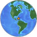
Magnitude 7.0 - HAITI REGION
2010 January 12 21:53:10 UTC
Earthquake Details
- This event has been reviewed by a seismologist.
| Magnitude | 7.0 |
|---|---|
| Date-Time |
|
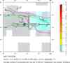
| Location | 18.443°N, 72.571°W |
| Depth | 13 km (8.1 miles) set by location program |
| Region | HAITI REGION |
| Distances | 25 km (15 miles) WSW of PORT-AU-PRINCE, Haiti 130 km (80 miles) E of Les Cayes, Haiti 150 km (95 miles) S of Cap-Haitien, Haiti 1125 km (700 miles) SE of Miami, Florida |
| Location Uncertainty | horizontal +/- 3.4 km (2.1 miles); depth fixed by location program |
| Parameters | NST=312, Nph=312, Dmin=143.7 km, Rmss=0.93 sec, Gp= 25°, M-type=teleseismic moment magnitude (Mw), Version=9 |
| Source |
|
| Event ID | us2010rja6 |

- Did you feel it? Report shaking and damage at your location. You can also view a map displaying accumulated data from your report and others.
Earthquake Summary

Felt Reports
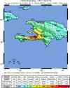
According to official estimates, 316,000 people killed, 300,000 injured, 1.3 million displaced, 97,294 houses destroyed and 188,383 damaged in the Port-au-Prince area and in much of southern Haiti. Other estimates suggest substantially lower numbers of casualties, perhaps as low as fewer than 100,000. The casualties include at least 4 people killed by a local tsunami in the Petit Paradis area near Leogane. Tsunami waves were also reported at Jacmel, Les Cayes, Petit Goave, Leogane, Luly and Anse a Galets. The tsunami had recorded wave heights (peak-to-trough) of 12 cm at Santo Domingo, Dominican Republic and 2 cm at Christiansted, US Virgin Islands. Uplift was observed along the coast from Leogane to L'Acul and subsidence was observed along the coast from Grand Trou to Port Royal. Felt (VIII) at Leogane; (VII) at Carrefour, Port-au-Prince and Petionville; (VI) at Vieux Bourg d'Aquin; (V) at Port-de-Paix. Felt (V) at La Vega, Moca and San Cristobal; (IV) at Bani, Bonao, Luperon, Nagua, Puerto Plata, Santiago, Santo Domingo and Sosua, Dominican Republic. Felt throughout Haiti and the Dominican Republic. Felt (III) at Oranjestad, Aruba; (IV) at Santiago de Cuba and (III) at Guantanamo, Cuba; (II) in the Kingston-Mona area, Jamaica; (II) at Carolina and San Juan, Puerto Rico; (III) at Cockburn Harbour and (II) at Cockburn Town, Turks and Caicos Islands; (III) at Maracaibo and (II) at Caracas, Venezuela. Felt in parts of The Bahamas, Puerto Rico and the US Virgin Islands and as far as southern Florida, northern Colombia and northwestern Venezuela.
Tectonic Summary
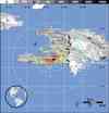
The January 12, 2010, Haiti earthquake occurred in the boundary region separating the Caribbean plate and the North America plate. This plate boundary is dominated by left-lateral strike slip motion and compression, and accommodates about 20 mm/y slip, with the Caribbean plate moving eastward with respect to the North America plate.
Haiti occupies the western part of the island of Hispaniola, one of the Greater Antilles islands, situated between Puerto Rico and Cuba. At the longitude of the January 12 earthquake, motion between the Caribbean and North American plates is partitioned between two major east-west trending, strike-slip fault systems -- the Septentrional fault system in northern Haiti and the Enriquillo-Plantain Garden fault system in southern Haiti.
The location and focal mechanism of the earthquake are consistent with the event having occurred as a combination of reverse and left-lateral strike slip faulting on the Enriquillo-Plantain Garden fault system. The overall Enriquillo-Plantain Garden fault system accommodates about 7 mm/y of motion, nearly half the total oblique convergence between the Caribbean and North America plates. The January 12 main shock did not produce observable surface displacement on the geomorphologically well-expressed main-strand of the Enriquillo-Plantain Garden fault system, but appears instead to have primarily involved rupture of a fault or faults distinct from the previously mapped principal strand, causing significant uplift of the Léogâne delta.
The Enriquillo-Plantain Garden fault system has not produced a major earthquake in recent decades. The EPGFZ is the likely source of historical large earthquakes in 1860, 1770, and 1751, though none of these has been confirmed in the field as associated with this fault.
Sequence of events possibly associated with the Enriquillo fault in 1751-1860 are as follows.
October 18, 1751: a major earthquake caused heavy destruction in the gulf of Azua (the eastern end of the Enriquillo Fault) which also generated a tsunami. It is unclear if the rupture occurred on the Muertos thrust belt or on the eastern end of Enriquillo Fault.
Nov. 21, 1751: a major earthquake destroyed Port-au-Prince but was centered to the east of the city on the Plaine du Cul-de-Sac.
June 3, 1770: a major earthquake destroyed Port-au-Prince again and appeared to be centered west of the city. As a result of the 1751 and 1770 earthquakes and minor ones in between, the authorities required building with wood and forbade building with masonry.
April 8, 1860: there was a major earthquake farther west accompanied by a tsunami.
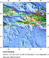
Aftershock Report
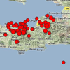
In the time period since the earthquake's origin at 2010-01-12 21:53 to 2010-02-23 17:00 UTC, the USGS NEIC has located 59 aftershocks of magnitude 4.5 or greater. Sixteen of these aftershocks have magnitudes of 5.0 or greater. The two largest aftershocks were magnitude 6.0 and 5.9. The M 6.0 aftershock occurred 7 minutes after the mainshock on January 12 and the M 5.9 event occurred at 11:03 UTC on January 20.
See Aftershock Map. (Map is updated manually and may be missing the latest information.)
Earthquake Information for Caribbean

Poster of the Seismicity of the Caribbean Plate and Vicinity
Earthquake Maps


Scientific & Technical Information
 USGS Centroid Moment Tensor Solution
- USGS Body-Wave Moment Tensor Solution
- Global CMT Project Moment Tensor Solution
- USGS WPhase Moment Tensor Solution
- Historic Moment Tensor Solutions
- Finite Fault Model
- Phase Data
- Theoretical P-Wave Travel Times
- Energy and Broadband Solution
- USGS–WHOI–DPRI Coulomb Stress-Transfer Model for the January 12, 2010, Mw=7.0 Haiti Earthquake (USGS Open-File Report 2010-1019)
- The MW 7.0 Haiti Earthquake of January 12, 2010: USGS/EERI Advance Reconnaissance Team Report - Open-File Report 2010-1048
- Documentation for Initial Seismic Hazard Maps for Haiti - USGS Open-File Report 1067
 Tsunami Information
The earthquake locations and magnitudes cited in NOAA tsunami statements and bulletins are preliminary and are superseded by USGS locations and magnitudes computed using more extensive data sets.
General Tsunami Information
Additional Information
- USAID Responds to Haiti Earthquake
- EERI Earthquake Clearinghouse for Haiti Earthquake
- Haiti Supersite - data sources for imagery,GIS, maps, etc
- Woods Hole Science Center Map of the North American - Caribbean tectonic plate boundary
- Caltech Tectonics Observatory Preliminary Slip Distribution Map
- IRIS "Teachable Moments" Education Resources for Haiti Earthquake
- ReliefWeb: Latest information on the relief efforts in Haiti
- Preliminary Earthquake Report
- U.S. Geological Survey, National Earthquake Information Center:
World Data Center for Seismology, Denver
