| |
||||||||
|
||||||||
Article |
|
| Map Projections: From Spherical Earth to Flat Map | |
|
|
|
| What is a Map Projection? | |
 A
map projection is a way to represent the curved surface of the Earth
on the flat surface of a map. A good globe can provide the most
accurate representation of the Earth. However, a globe isn't
practical for many of the functions for which we require maps. Map
projections allow us to represent some or all of the Earth's
surface, at a wide variety of scales, on a flat, easily transportable
surface, such as a sheet of paper. Map projections also apply to
digital map data, which can be presented on a computer screen. A
map projection is a way to represent the curved surface of the Earth
on the flat surface of a map. A good globe can provide the most
accurate representation of the Earth. However, a globe isn't
practical for many of the functions for which we require maps. Map
projections allow us to represent some or all of the Earth's
surface, at a wide variety of scales, on a flat, easily transportable
surface, such as a sheet of paper. Map projections also apply to
digital map data, which can be presented on a computer screen.
There are hundreds of different map projections. The process of transferring information from the Earth to a map causes every projection to distort at least one aspect of the real world – either shape, area, distance, or direction. Each map projection has advantages and disadvantages; the appropriate projection for a map depends on the scale of the map, and on the purposes for which it will be used. For example, a projection may have unacceptable distortions if used to map the entire country, but may be an excellent choice for a large-scale (detailed) map of a county. The properties of a map projection may also influence some of the design features of the map. Some projections are good for small areas, some are good for mapping areas with a large east-west extent, and some are better for mapping areas with a large north-south extent. Some projections have special properties. For example, a Mercator projection has straight rhumb lines and is therefore excellent for navigation, because compass courses are easy to determine. |
|
| back
to top |
|
| Classes of Map Projections and Their Use | |
| There are several ways
to classify the wide variety of map projections. One of the most common
classifications is by distortion characteristics: which properties
of the Earth does the projection maintain? Which does it distort?
Classification based on distortion characteristics
A projection that maintains accurate distances from the center of the projection or along given lines is called an equidistant projection. These projections are used for radio and seismic mapping, and for navigation. Examples are the Equidistant Conic projection and the Equirectangular projection. The Azimuthal Equidistant projection is the projection used for the emblem of the United Nations. A projection that maintains accurate directions (and therefore angular relationships) from a given central point is called an azimuthal or zenithal projection. These projections are used for aeronautical charts and other maps where directional relationships are important. Examples are the Gnomonic projection and the Lambert Azimuthal Equal-Area projection. A map projection may combine several of these characteristics,
or may be a compromise that distorts all the properties of shape,
area, distance, and direction, within some acceptable limit. Examples
of compromise projections are the Winkel Tripel projection and the
Robinson projection, often used for world maps. |
|
| Classification
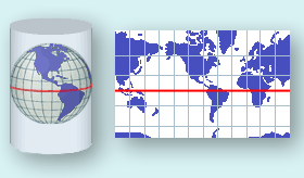
based on developable surface Map projections can also be classified based on the shape of the developable surface to which the Earth's surface is projected. A developable surface is a simple geometric form capable of being flattened without stretching, such as a cylinder, cone, or plane.  Cylindrical projection For example, a cylindrical projection projects information from the spherical Earth to a cylinder. The cylinder may be either tangent to the Earth along a selected line, or may be secant (intersect the Earth) along two lines. Imagine that once the Earth's surface is projected, the cylinder is unwrapped to form a flat surface. The lines where the cylinder is tangent or secant are the places with the least distortion.
|
|
|
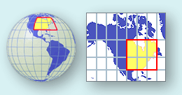
A planar projection projects information to a plane. The plane may be either tangent or secant. |
|
| back
to top |
|
| Commonly Used Map Projection Terms | |
| Azimuth—The
angle, measured in degrees, between a base line radiating from a center
point and another line radiating from the same point. Normally, the
base line points North, and degrees are measured clockwise from the
base line.
Azimuthal—A map projection in which the direction from a given central point to any other point is shown correctly. Also called a zenithal projection. Aspect—The placement of a projection system relative to the Earth's axis. A polar aspect is tangent at the pole, an equatorial aspect is tangent at the Equator, and an oblique aspect is tangent anywhere else. (The word "aspect" has replaced the word "case" in the modern cartographic literature.) Cartesian coordinate system —A coordinate system in which a point's location is described by its distances from a set of perpendicular lines that intersect at an origin, either two lines in a plane or three in space. Conformal—A map projection in which the angles at each point are preserved. This means that the shapes of small areas are maintained accurately. The size of most areas, however, is distorted. Conic—A map projection where the Earth's surface is projected onto a tangent or secant cone, which is then cut from apex to base and laid flat. |
|
 |
|
|
Cylindrical—A map projection where the Earth's surface is projected onto a tangent or secant cylinder, which is then cut lengthwise and laid flat. Datum—A reference for position on the surface of the Earth. In surveying, a datum is a reference system for computing or correlating the results of surveys. There are two principal types of datums: vertical and horizontal. A vertical datum is a level surface to which heights are referred. In the United States, the generally adopted vertical datum for leveling operations is the National Geodetic Vertical Datum of 1929. The horizontal datum is used as a reference for position. The North American Datum of 1983 is based on the Geodetic Reference System 1980 (GRS80) spheroid; it is an Earth-centered datum having no initial point or initial direction. This is the horizontal datum used for National Atlas map layers. Developable surface—A developable surface is a simple geometric form capable of being flattened without stretching. Map projections can be grouped by the developable surface they use: cylinder, cone, or plane. Ellipsoid—A mathematical figure that approximates the shape of the Earth in form and size, and which is used as a reference surface for geodetic surveys. Used interchangeably with Spheriod. Equal-area—A map projection where every part, as well as the whole, has the same area as the corresponding part on the Earth, at the same reduced scale. Equator—The line which encircles the Earth at an equal distance from the North and South Poles. Equidistant—A map projection that shows true distances from the center of the projection or along a special set of lines. For example, an Azimuthal Equidistant map centered at Washington, DC, shows the correct distance between Washington, DC, and any other point on the projection. It shows the correct distance between Washington, DC, and San Diego and between Washington, DC, and Seattle, but it does not show the correct distance between San Diego and Seattle. Graticule—A network of lines representing a selection of the Earth's parallels and meridians. Great circle—A circle formed on the surface of a sphere by a plane that passes through the center of the sphere. The Equator, each meridian, and each other full circumference of the Earth forms a great circle. The arc of a great circle shows the shortest distance between points on the surface of the Earth. Grid—Two sets of parallel lines intersecting at right angles, forming a rectangular Cartesian coordinate system superimposed on a map projection. Sometimes the term "grid" is used loosely to mean the projection system itself rather than the rectangular system superimposed on the projection. Latitude—Angular distance, in degrees, minutes, and seconds measured from the center of the Earth, of a point north or south of the Equator. Latitude may also be measured in decimal degrees. Longitude—Angular distance, in degrees, minutes, and seconds measured from the center of the Earth, of a point east or west of the Prime Meridian. Longitude may also be measured in decimal degrees. Meridian—A great circle on the surface of the Earth, passing through the geographical poles and some third point on the Earth's surface. All points on a given meridian have the same longitude. Parallel—A circle or approximation of a circle on the surface of the Earth, parallel to the Equator and connecting points of equal latitude. Planar—A map projection resulting from the conceptual projection of the Earth onto a tangent or secant plane. Usually, a planar projection is the same as an azimuthal projection. |
|
 |
|
|
Prime Meridian—The meridian of longitude 0 degrees, used as the origin for the measurement of longitude. The meridian of Greenwich, England, is the internationally accepted prime meridian in most cases. Projection parameters—A series of values that define a particular projection, and that tell how the projection is related to the Earth. Projection parameters may indicate the point of tangency, or the lines where a secant surface intersects the Earth. They also define the spheriod used to create the projection, and any other information necessary to identify the projection. Rhumb line—A rhumb line is a line on the surface of the Earth cutting all meridians at the same angle. A rhumb line shows true direction. Parallels and meridians, which also maintain constant true directions, may be considered special cases of the rhumb line. A rhumb line is a straight line on a Mercator projection. A straight rhumb line does not show the shortest distance between points unless the points are on the Equator or on the same meridian. A navigator can proceed between any two points along a rhumb line by maintaining a constant bearing, or compass direction. Scale—The relationship between a distance on a map, chart, or photograph, and the corresponding distance on the Earth. Scale is usually given as a fraction or ratio: 1:2,000,000, or 1/2,000,000. Secant—Cutting the sphere or spheroid along a line or lines. A secant cone or cylinder intersects the sphere or spheroid along two separate lines; these lines are parallels of latitude if the axes of the geometric figures coincide. A secant plane intersects the sphere or spheroid along a line that is a parallel of latitude if the plane is at right angles to the axis. Spherical – Approximating the shape of a sphere. Spheroid—A mathematical figure that approximates the shape of the Earth in form and size, and which is used as a reference surface for geodetic surveys. Used interchangeably with Ellipsoid. Tangent—Touching at a single point or along a single line. A tangent cone or cylinder touches the sphere or spheroid along a single line. This line is a parallel of latitude if the axes of the geometric figures coincide. Zenithal—A map projection in which the direction from a given central point to any other point is shown correctly. Also called an azimuthal projection. |
|
| back
to top |
|
| Related Links | |
|
|
|
References Bugayevskiy, Lev M. and John P. Snyder; Map Projections – A Reference Manual; Taylor and Francis Inc., Bristol, PA; 1995 Snyder, John P.; Map Projections – A Working Manual; U.S. Geological Survey Professional Paper 1395; Washington, DC; 1987 Snyder, John P., and Philip M. Voxland; An Album of Map Projections; U.S. Geological Survey Professional Paper 1453; Denver, CO; 1989 Thompson, Morris M.; Maps for America, Third Edition; U.S. Geological Survey; Reston, VA; 1988 USGS, Map Projections , January 13, 2003 Map projections as essential tools of physical oceanography. , January 13, 2003 The
Atlas of Canada, Learning Resources, Map
Making, Map Projections. |
|
| back
to top |
 The National Atlas of the United States uses a Lambert Azimuthal
Equal-Area projection to display information in the online
The National Atlas of the United States uses a Lambert Azimuthal
Equal-Area projection to display information in the online