Tropical Cyclone Report
Tropical Storm Georgette
26 - 30 August 2004
Stacy R. Stewart
National Hurricane Center
14 October 2004
Revised: 2 December 2004
Tropical Storm Georgette was a short-lived,
west-northwestward-moving tropical cyclone that remained over the
open northeastern Pacific Ocean.
a. Synoptic History
The tropical wave that eventually spawned
Georgette moved across the west coast of Africa on 15 August. The
wave moved westward across the tropical Atlantic Ocean with little
associated shower activity until it reached the Gulf of Tehuantepec
in the northeastern Pacific Ocean on 24 August. By early on 25
August, deep convection increased and became better organized, and
a QuikSCAT overpass indicated a weak surface low pressure area had
formed along the wave axis. Convection continued to increase during
the day and Dvorak classifications were initiated on the system at
1800 UTC. Banding features improved significantly overnight and the
cloud pattern was sufficiently well-organized to designate the
system as a tropical depression at 1200 UTC 26 August, centered
about 525 n mi south-southeast of the southern tip of Baja
California. The "best track" chart of the tropical
cyclone=s path is given in Figure 1, with the
wind and pressure histories shown in
Figure 2 and Figure 3, respectively.
The best track positions and intensities are listed in Table 1.
Deep convection continued to quickly
organize and it is estimated that the tropical cyclone strengthened
into Tropical Storm Georgette by around 1800 UTC 26 August.
Georgette moved northwestward at 12-15 kt and, based on Dvorak
satellite classifications and supplemental microwave satellite data
(Figure 4), reached its peak intensity of 55 kt at about 1200 UTC 27
August. Shortly thereafter, upper-level northeasterly shear brought
about a slow weakening trend while the cyclone was moving
west-northwestward along the southern periphery of a strong
subtropical high. Both the steering and shear patterns persisted
for the next 3 days, and Georgette slowly weakened while it moved
west-northwestward at 10-15 kt over cooler water. It is estimated
that Georgette became a depression again by 0600 UTC 30 August
about 770 n mi west of southern tip of Baja California. Weakening
continued and the tropical cyclone quickly degenerated into a
non-convective low pressure system by 1800 UTC that day. The
remnant low remained devoid of significant convection as it moved
west-northwestward over progressively colder water for the next 4
days. It finally dissipated early on 3 September about 520 n mi
northeast of Hawaii.
b. Meteorological Statistics
Observations in Tropical Storm Georgette
(Figure 2 and Figure 3)
include satellite-based Dvorak technique intensity
estimates from the Tropical Analysis and Forecast Branch (TAFB),
the Satellite Analysis Branch (SAB), and the U. S. Air Force
Weather Agency (AFWA). Microwave imagery from NOAA polar-orbiting
satellites, the NASA Tropical Rainfall Measuring Mission (TRMM),
the NASA QuikSCAT program, and the Defense Meteorological Satellite
Program (DMSP) was also useful in tracking Tropical Storm
Georgette.
Georgette's peak intensity of 55 kt at 1200
UTC 27 August is estimated to have occurred approximately 6h before
the highest Automated Objective Dvorak Technique (AODT) intensity
estimate of 62 kt was observed (Figure 2). The lower intensity is
based on subsequent DMSP microwave imagery (not shown) at 1645 UTC
indicating that convection underneath the cold cloud canopy had
actually weakened and had become much less organized than the AODT
intensity estimate of 62 kt suggests. It is possible that the AODT
algorithm was unable to distinguish between a cold CDO feature and
a weaker Central Cold Cover (CCC) cloud pattern and/or placement of
the low-level center was too far into the convective cloud
canopy.
There were no reports of winds of tropical
storm force associated with Georgette.
c. Casualty and Damage Statistics
There were no reports of damage or
casualties associated with Tropical Storm Georgette.
d. Forecast and Warning Critique
Georgette was a tropical cyclone for only
96 h, resulting in a relatively small number of forecasts to
verify. Average official track errors (with the number of cases in
parentheses) for Georgette were 30 (15), 44 (13), 56 (11), 58 (9),
41 (5) n mi for the 12, 24, 36, 48, 72 h forecasts, respectively.
These errors are much lower than the average official track errors
for the 10-yr period 1994-2003[1] of 38, 70, 100, 127, and 180 n
mi, respectively (Table 2).
Average official intensity errors were 6,
10, 12, 12, and 20 kt for the 12, 24, 36, 48, and 72 h forecasts,
respectively. These errors are comparable to the average official
intensity errors over the 10-yr period 1994-2003 of 6, 11, 15, 17,
and 20 kt, respectively.
No watches or warnings were associated with
Georgette.
[1]Errors given
for the 96 and 120 h periods are averages over the three-year
period 2001-3.
Table 1: Best track for
Tropical Storm Georgette, 26-30 August 2004.
Date/Time
(UTC) | Position | Pressure
(mb) | Wind Speed
(kt) | Stage |
Lat.
(°N) | Lon.
(°W) |
| 26 / 1200 | 14.7 | 106.0 | 1006 | 30 | tropical depression |
| 26 / 1800 | 15.6 | 107.0 | 1005 | 35 | tropical storm |
| 27 / 0000 | 16.5 | 108.4 | 1002 | 40 | " |
| 27 / 0600 | 17.3 | 109.9 | 998 | 50 | " |
| 27 / 1200 | 17.9 | 111.3 | 995 | 55 | " |
| 27 / 1800 | 18.3 | 112.8 | 998 | 50 | " |
| 28 / 0000 | 18.5 | 114.2 | 1000 | 45 | " |
| 28 / 0600 | 18.6 | 115.4 | 1000 | 45 | " |
| 28 / 1200 | 18.7 | 116.6 | 1000 | 45 | " |
| 28 / 1800 | 18.8 | 117.5 | 998 | 50 | " |
| 29 / 0000 | 19.0 | 118.5 | 997 | 50 | " |
| 29 / 0600 | 19.1 | 119.4 | 999 | 45 | " |
| 29 / 1200 | 19.3 | 120.3 | 1000 | 45 | " |
| 29 / 1800 | 19.5 | 121.3 | 1001 | 45 | " |
| 30 / 0000 | 19.7 | 122.4 | 1004 | 35 | " |
| 30 / 0600 | 19.9 | 123.4 | 1007 | 30 | tropical depression |
| 30 / 1200 | 20.1 | 124.4 | 1007 | 25 | " |
| 30 / 1800 | 20.3 | 125.6 | 1008 | 20 | remnant low |
| 31 / 0000 | 20.5 | 127.0 | 1009 | 20 | " |
| 31 / 0600 | 20.8 | 128.5 | 1009 | 20 | " |
| 31 / 1200 | 21.0 | 130.0 | 1009 | 20 | " |
| 31 / 1800 | 21.1 | 131.5 | 1010 | 20 | " |
| 01 / 0000 | 21.2 | 133.0 | 1010 | 20 | " |
| 01 / 0600 | 21.3 | 134.0 | 1010 | 20 | " |
| 01 / 1200 | 21.3 | 135.0 | 1010 | 20 | " |
| 01 / 1800 | 21.3 | 136.0 | 1010 | 20 | " |
| 02 / 0000 | 21.3 | 137.2 | 1010 | 20 | " |
| 02 / 0600 | 21.4 | 138.6 | 1011 | 15 | " |
| 02 / 1200 | 21.7 | 140.2 | 1011 | 15 | " |
| 02 / 1800 | 22.3 | 141.7 | 1011 | 15 | " |
| 03 / 0000 | 22.9 | 143.1 | 1011 | 15 | " |
| 03 / 0600 | 23.1 | 144.6 | 1012 | 15 | " |
| 03 / 1200 | 23.1 | 146.1 | 1013 | 15 | " |
| 03 / 1800 | | | | | dissipated |
| 27 / 1200 | 17.9 | 111.3 | 995 | 55 | minimum pressure |
Table 2: Final forecast
evaluation (heterogeneous sample) for Tropical Storm Georgette,
26-30 August 2004. Forecast errors (n mi) are followed by the
number of forecasts in parentheses. Errors smaller than the NHC
official forecast are shown in bold-face type. Verification
includes the depression stage, but does not include the
extratropical stage, if any.
| Forecast Technique | Period (hours) |
| 12 | 24 | 36 | 48 | 72 | 96 | 120 |
| CLP5 | 41 (15) | 78 (13) | 121 (11) | 160 (9) | 308 (5) | 451 (1) | |
| GFNI | 51 (13) | 80 (10) | 103 (8) | 108 (6) | 167 (2) | | |
| GFDI | 27 (14) | 42 (12) | 51 (10) | 68 (8) | 89 (4) | | |
| GFDL | 26 (15) | 41 (13) | 45 (11) | 56 (9) | 60 (5) | 113 (1) | |
| GFDN | 54 (14) | 98 (12) | 117 (9) | 121 (7) | 123 (3) | | |
| LBAR | 43 (14) | 81 (12) | 120 (10) | 163 (9) | 244 (5) | 189 (1) | |
| GFSI | 24 (14) | 38 (12) | 50 (10) | 61 (8) | 103 (4) | | |
| GFSO | 24 (15) | 41 (13) | 59 (11) | 73 (9) | 114 (5) | 175 (1) | |
| AEMI | 20 (9) | 26 (8) | 33 (7) | 38 (5) | 64 (3) | | |
| BAMD | 45 (15) | 82 (13) | 129 (11) | 180 (9) | 263 (5) | 317 (1) | |
| BAMM | 38 (15) | 66 (13) | 108 (11) | 163 (9) | 292 (5) | 360 (1) | |
| BAMS | 38 (14) | 52 (12) | 73 (10) | 103 (9) | 218 (5) | 288 (1) | |
| NGPI | 47 (13) | 89 (11) | 128 (9) | 142 (7) | 226 (3) | | |
| NGPS | 50 (14) | 90 (12) | 131 (10) | 146 (8) | 242 (4) | | |
| UKMI | 45 (14) | 92 (12) | 128 (10) | 150 (8) | 115 (4) | | |
| UKM | 61 (8) | 92 (7) | 127 (6) | 156 (5) | 164 (3) | | |
| GUNS | 30 (13) | 53 (11) | 75 (9) | 84 (7) | 132 (3) | | |
| GUNA | 23 (13) | 38 (11) | 50 (9) | 56 (7) | 93 (3) | | |
| OFCL | 30 (15) | 44 (13) | 56 (11) | 58 (9) | 41 (5) | 102 (1) | |
| NHC Official (1994-2003 mean) | 38 (2746) | 70 (2474) | 100 (2196) | 127 (1928) | 180 (1476) | 210 (283) | 247 (179) |
|
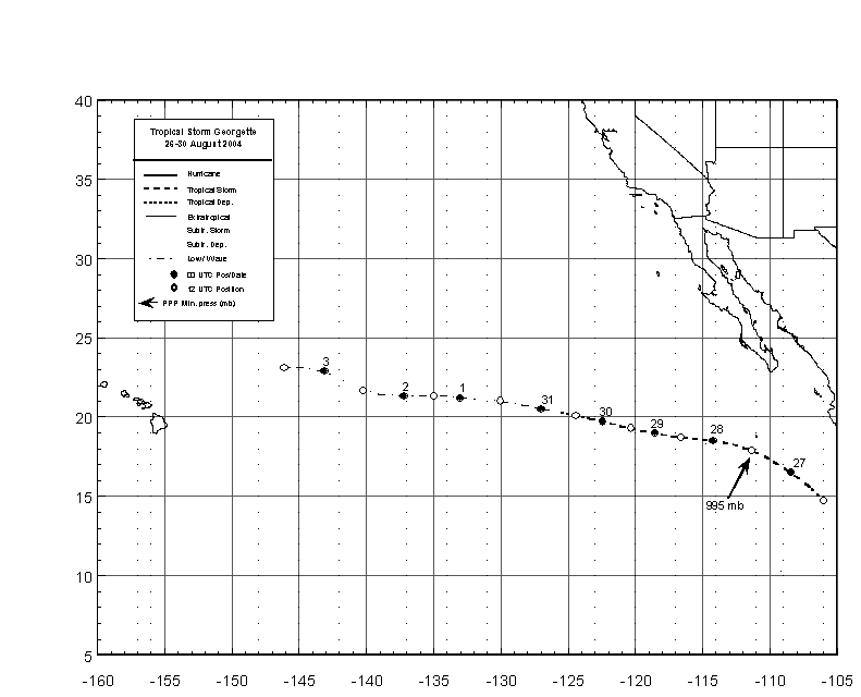
Figure 1:
Best track positions for Tropical
Storm Georgette, 26-30 August 2004.

Figure 2:
Selected wind observations and best track maximum sustained
surface wind speed curve for Tropical Storm Georgette, 26-30 August 2004.
Objective Dvorak estimates represent linear averages over a three-hour
period centered on the nominal observation time.

Figure 3:
Selected pressure observations
and best track minimum central pressure curve for Tropical Storm
Georgette, 26-30 August 2004. Objective Dvorak estimates represent
linear averages over a three-hour period centered on the nominal
observation time.

Figure 4:
0902 UTC 27 August 2004 AMSR-E
AQUA-1 overpass with composite images
showing the tight circulation of Tropical
Storm Georgette near its peak intensity of 55 kt (image courtesy of
the Naval Research Laboratory, Monterey, CA).
|


