

The Library of Congress serves as the research arm of Congress and
is recognized as the national library of the United States. It is
the world`s largest library and a great resource to scholars and
researchers.
In the Geography and Map Division Reading Room of the Library of
Congress, researchers can find the largest and most comprehensive
cartographic collection in the world. There are more than 4.5 million
maps and 60,000 atlases, as well as a large number of cartographic
materials in other formats.
The U. S. Geological Survey and the Library of Congress initiated
a partnership in October 2001 to bring you some of these unique
maps.
|
The image below links to a detailed PDF file.
You can download a copy of Adobe Acrobat Reader here 
|

|

(1,013 Kb)
Actual Size: 39.7" x 26.72"
|
1702 - A New and Correct Map of The World
Map originally sold by Willdey at ye Great Toy & Print Shop
ye corner of Ludgate Street next So. Pauls Church Yard London,
1702 (Reproduction.)
Stock Number: 114474
Price $20.00
[Top of Page]
|

(2,483 Kb)
Actual Size: 25.37" x 17.85"
|
1796 - Map of The Country of The Illinois,
Parts of The Upper Louisanna
Map investigated and plotted by a French Army Lieutenant
prior to the Louisiana Purchase and covers the area that is
now St. Louis, where the Missouri River meets the Mississippi
River and extends south. Map by George Henri Victor Collot
and P.F. Tardieu.
Stock Number #: 115319
Price $20.00
[Top of Page]
|

(1,418 Kb)
Actual Size: 54.5" x 42"
For additional information, please
visit
The
Lewis and Clark Expedition and The USGS &
Lewis and Clark and the USGS in North Dakota websites.
|
Lewis and Clark: A Legacy of Science
Featuring 1814 map "Lewis and Clark's
Track"
A new poster from the USGS commemorates the
200th anniversary of the Lewis and Clark Trek. The poster
features a beautiful reproduction of "Lewis and Clark's
Track" and the same geographic area depicted with
national elevation data from
The National Map in a colorful image
of the American landscape. The parallel map construction illustrates
how difficult Lewis and Clark's expedition was, how well they
mapped the terrain, and how far cartographic techniques have
advanced in 200 years.
Stock Number #: 113605
Price $10.00
|

(969 Kb)
Actual Size: 30" x 38"
|
1849 - Map of North America
Map of North America including part of the West India Islands.
Published by C. Smith, Mapseller, London, 1849. Colors are
used to outline boundaries. (Reproduction.)
Stock Number #: 114327
Price $20.00
[Top of Page]
|

(410 Kb)
Actual Size: 32¾" x 19½"
|
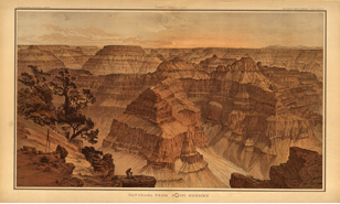
1882 - The Grand Cañon At The Foot of The
Toroweap - Looking East
This panoramic view of the Grand Canyon by William H. Holmes
was published in Clarence E. Dutton's 1882 "Atlas to Accompany
the Monograph on the Tertiary History of the Grand Cañon District."
Holmes was the scientific illustrator of topographic and
geologic phenomena for the Great Western Surveys following
the Civil War. (Reproduction.)
Stock Number: 114455
Price $20.00
[Top of Page]
|
(403 Kb)
Actual Size: 32¾" x 19½"
|
1882 - Panorama From Point Sublime
This panoramic view of the Grand Canyon by William H. Holmes
was published in Clarence E. Dutton's 1882 "Atlas to Accompany
the Monograph on the Tertiary History of the Grand Cañon District."
Holmes was the scientific illustrator of topographic and
geologic phenomena for the Great Western Surveys following
the Civil War. (Reproduction.)
Stock Number: 114454
Price $20.00
[Top of Page]
|
(2,804 Kb)
Actual Size: 53" x 42"
|
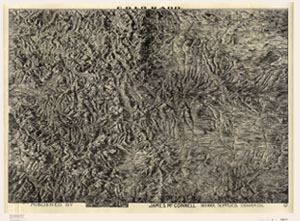
1894 - Historic Map of Colorado
Looking for an attractive historical map of Colorado? Reproduced
by USGS in cooperation with the Library of Congress, this
map was originally published in 1894 by James McConnell School
Supplies of Denver, Colorado. This unique birds-eye view map
has incredible detail and is ideal for framing. Features include:
relief shading, counties, cities, towns, roads, rivers, valleys,
railroads, and elevations of some mountain peaks. It is interesting
to note how some features' names and spellings have changed
since 1894. The map is scaled at approximately 1:500,000.
Stock Number #: 112161
Price $12.00
[Top of Page]
|
(1,638 Kb)
Actual Size: 40" x 51½"
|
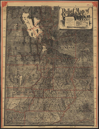
1895 - Relief Map of Utah
Relief Map of Utah. Published by Pierce & McMillen, Salt
Lake City, 1895. Drawn by Mosiah Hall, Superintendent of Schools,
Weber County, and assisted by Charles Wright. County borders
and minerals are illustrated on the map in red. Also included
are demographics about the state and a statement that the
map was "Designed for the home, the office, and especially
for Schools." (Reproduction.)
Stock Number #: 113455
Price $20.00
[Top of Page]
|
More Historic Maps Are Coming Soon!
Please check back with us later!
View Fact
Sheet 154-99 for additional information on these and
other historical maps.
|

|