
This service provided by the National Oceanic and Atmospheric Administration's (NOAA)
National Environmental Satellite, Data and Information Service (NESDIS)
This service provided by the National Oceanic and Atmospheric Administration's (NOAA)
National Environmental Satellite, Data and Information Service (NESDIS)
On October 21, 1998, a tropical depression formed in the southern Caribbean Sea. One day later, the storm became a tropical storm and was given the name "Mitch". Mitch moved very little over the next few days, drifting to the northwest, and gathering strength. A sharp increase in intensity occurred between the afternoon of October 23 and October 26 during which time Mitch strengthened from a tropical storm with 60 knot winds, to a Saffir-Simpson Category 5 hurricane with winds of 155 knots.
The hurricane continued to gather strength as it moved to the northwest very slowly. Winds in the storm reached a peak of 157 knots (180 MPH) on October 26 just off the northeast coast of Honduras. This made Mitch the strongest hurricane in the Caribbean sea in over a decade. Mitch maintained this level of intensity for nearly 24 hours before beginning to weaken.
By the morning of October 28, winds associated with Hurricane Mitch had decreased to 105 knots. The storm was located just north of Honduras and was drifting to the west. By this point, however, the real story was not the wind but the rain. The slow movement of the storm had caused heavy rain in Central America over the past few days, but especially in Honduras and Nicaragua. Now with the storm stalled to the north, the rains increased in intensity and coverage. Widespread, catastrophic flooding and mudslides were the result. By the time Tropical Storm Mitch made landfall on the 29th, the damage and loss of life was already extensive.
Mitch weakened rapidly once it arrived onshore but the mountainous regions of Honduras and Nicaragua continued to "squeeze" the moisture out of the system. The circulation center began to turn to the north and emerged into the Gulf of Mexico on November 2. As Mitch began to redevelop, it interacted with a cold front that was extending into the Gulf. The storm began to increase its forward speed to the east-northeast and on November 4, winds associated with the storm increased again to tropical storm strength. Mitch was reclassified as a tropical storm although much of the wind field was displaced from the center, meaning that the storm was losing its tropical characteristics.
Later on the 4th, Mitch hit the west coast of Florida with winds that gusted to near 70 knots. The storm's forward speed had increased to 23 knots and it cleared Florida later that evening. Once in the Atlantic, meteorologists at the Tropical Prediction Center determined that Mitch no longer had tropical characteristics and classified the storm as "extratropical".
Satellite images were produced from data received from the Geostationary Operational Environmental Satellite - 8 (GOES - 8)
and the Polar-orbiting Environmental Satellites (POES) NOAA-12 and NOAA-14. For more images of Mitch and other tropical storms,
including storms from earlier this year, visit the Operational Significant Event Imagery server welcome page at
http://www.osei.noaa.gov.
| Hurricane Mitch Imagery |
Multichannel color and grayscale composite images from GOES, NOAA-12 and NOAA-14. Click on the image below to view the full-resolution version.
 11/04/98 20:32 UTC | NOAA-14 | TS 46 mph
|
Channels 1,2,4 | |
 11/04/98 13:20 UTC | NOAA-15 | TS 46 mph
|
Channels 1,2,4 | |
 11/03/98 20:44 UTC | NOAA-14 | No classification
|
Channels 1,2,4 | |
 10/30/98 20:45 UTC | GOES-8 | TS 58 mph
|
Channels 1,2,4 | |
 10/30/98 13:45 UTC | GOES-8 | TS 58 mph
|
Channels 1,2,4 | |
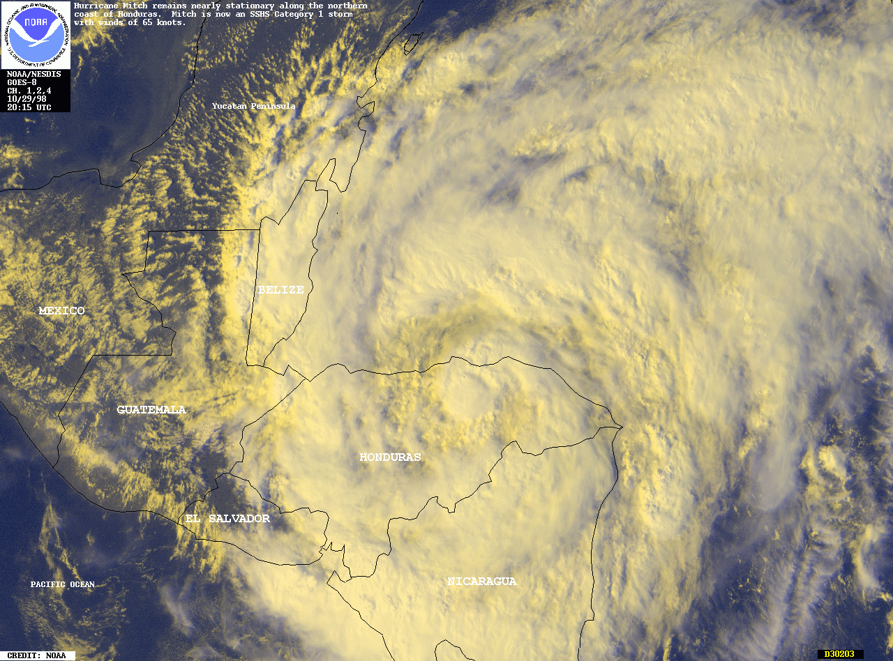 10/29/98 20:15 UTC | GOES-8 | H1 75mph
|
Channels 1,2,4 | |
 10/29/98 15:15 UTC | GOES-8 | H1 75 mph
|
Channels 1,2,4 | |
 10/29/98 11:38 UTC | NOAA-12 | H1 80 mph
|
Channels 3,4,5 | |
 10/28/98 16:45 UTC | GOES-8 | H3 120 mph
|
Channels 1,2,4 | |
 10/28/98 13:15 UTC | GOES-8 | H3 120 mph
|
Channels 1,2,4 | |
 10/28/98 11:48 UTC | NOAA-12 | H3 120 mph
|
Channels 2,3,5 | |
 10/27/98 20:21 UTC | NOAA-14 | H4 155 mph
|
Channels 1,2,4 | |
 10/27/98 20:21 UTC | NOAA-14 | H4 155 mph
|
Channels 1,2,4 | |
 10/27/98 13:00 UTC | NOAA-15 | H5 180 mph
|
Channels 1,2,4 | |
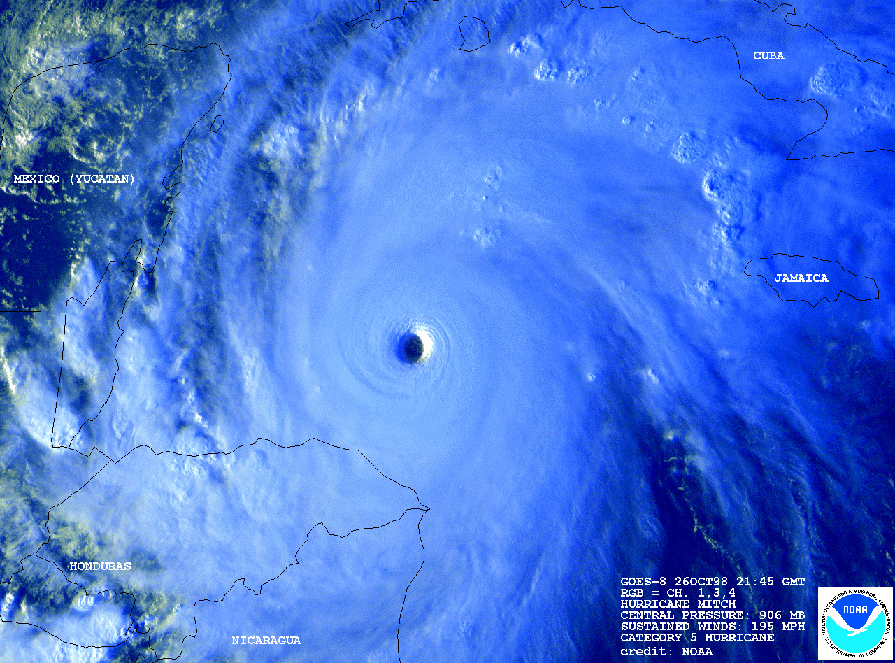 10/26/98 21:45 UTC | GOES-8 | H5 180 mph
|
Channels 1,3,4 | |
 10/26/98 21:45 UTC | GOES-8 | H5 180 mph
|
Channels 1,3,4 | |
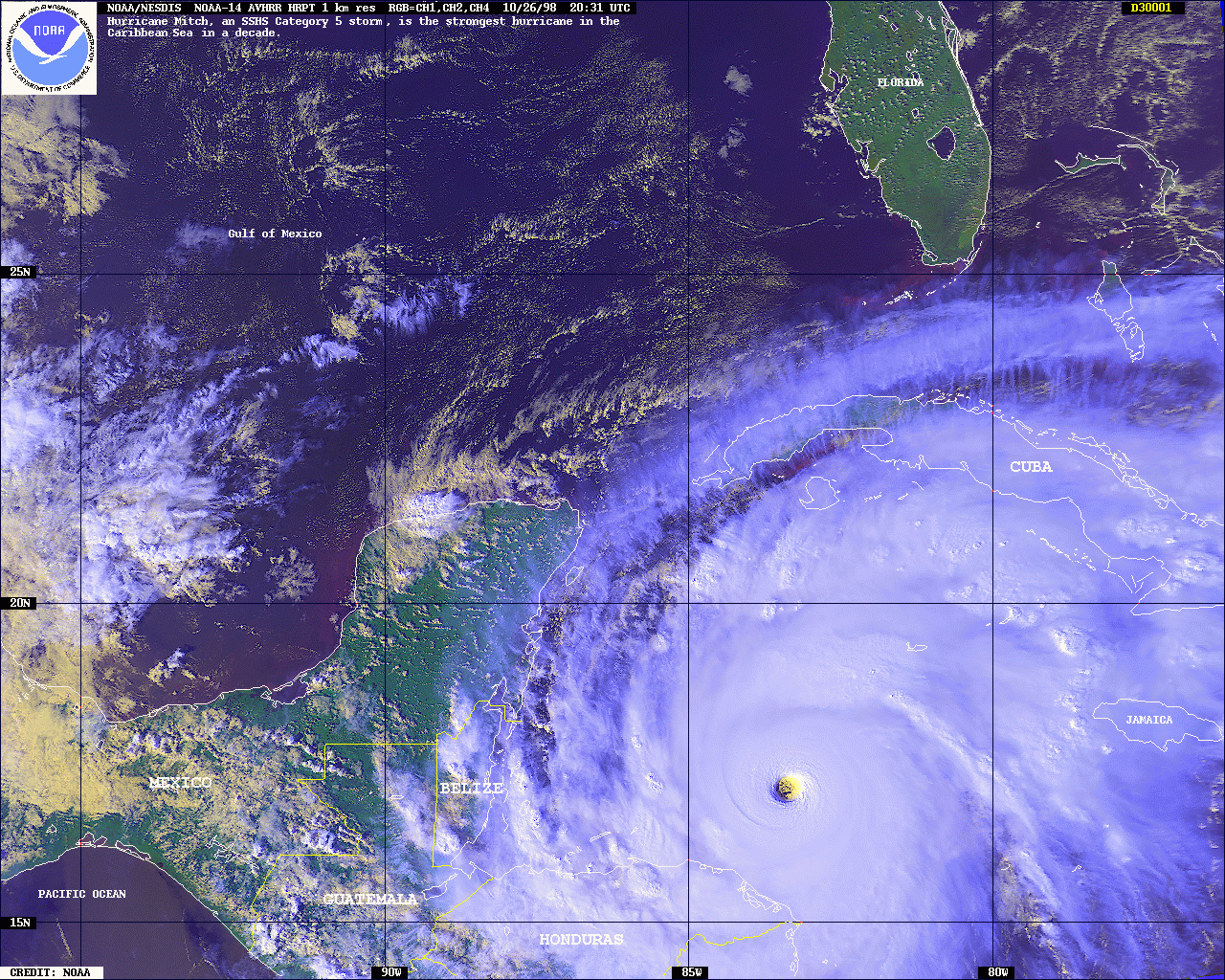
 10/26/98 20:31 UTC | NOAA-14 | H5 180 mph
|
Channels 1,2,4 | |
 10/26/98 20:31 UTC | NOAA-14 | H5 180 mph
|
Channels 1,2,4 | |
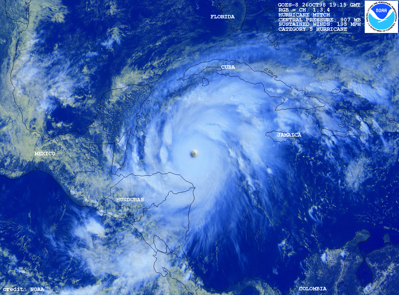
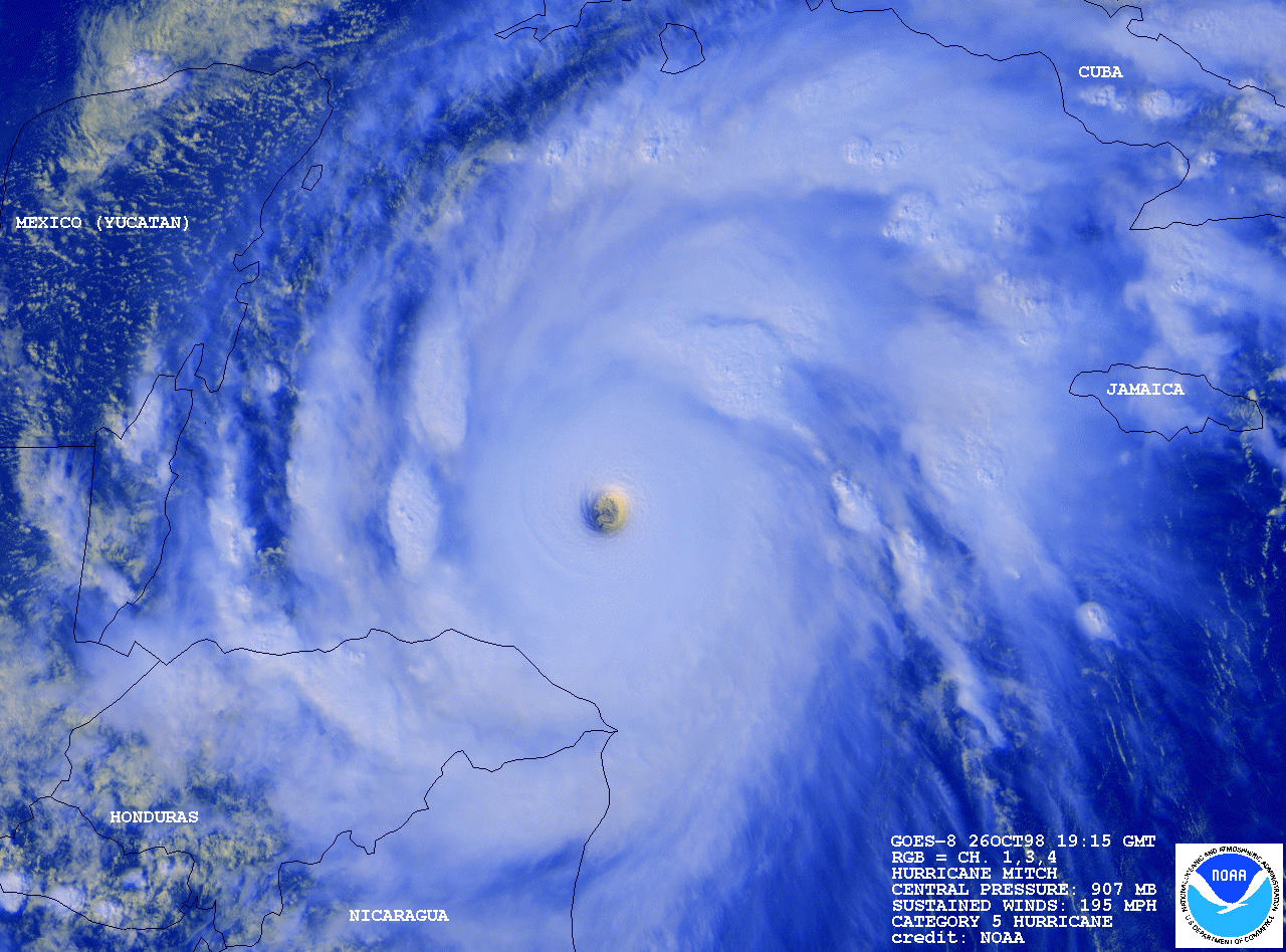 10/26/98 19:15 UTC | GOES-8 | H5 180 mph
|
Channels 1,3,4 | |
 10/26/98 19:15 UTC | GOES-8 | H5 180 mph
|
Channels 1,3,4 | |
 10/26/98 16:15 UTC | GOES-8 | H5 180 mph
|
Channels 1,3,4 | |
 10/26/98 16:15 UTC | GOES-8 | H5 180 mph
|
Channels 1,3,4 | |
 10/26/98 13:45 UTC | GOES-8 | H4 155 mph
|
Channels 1,3,4 | |
 10/26/98 13:45 UTC | GOES-8 | H4 155 mph
|
Channels 1,3,4 | |
 10/26/98 13:20 UTC | NOAA-15 | H4 155 mph
|
Channels 1,2,4 | |
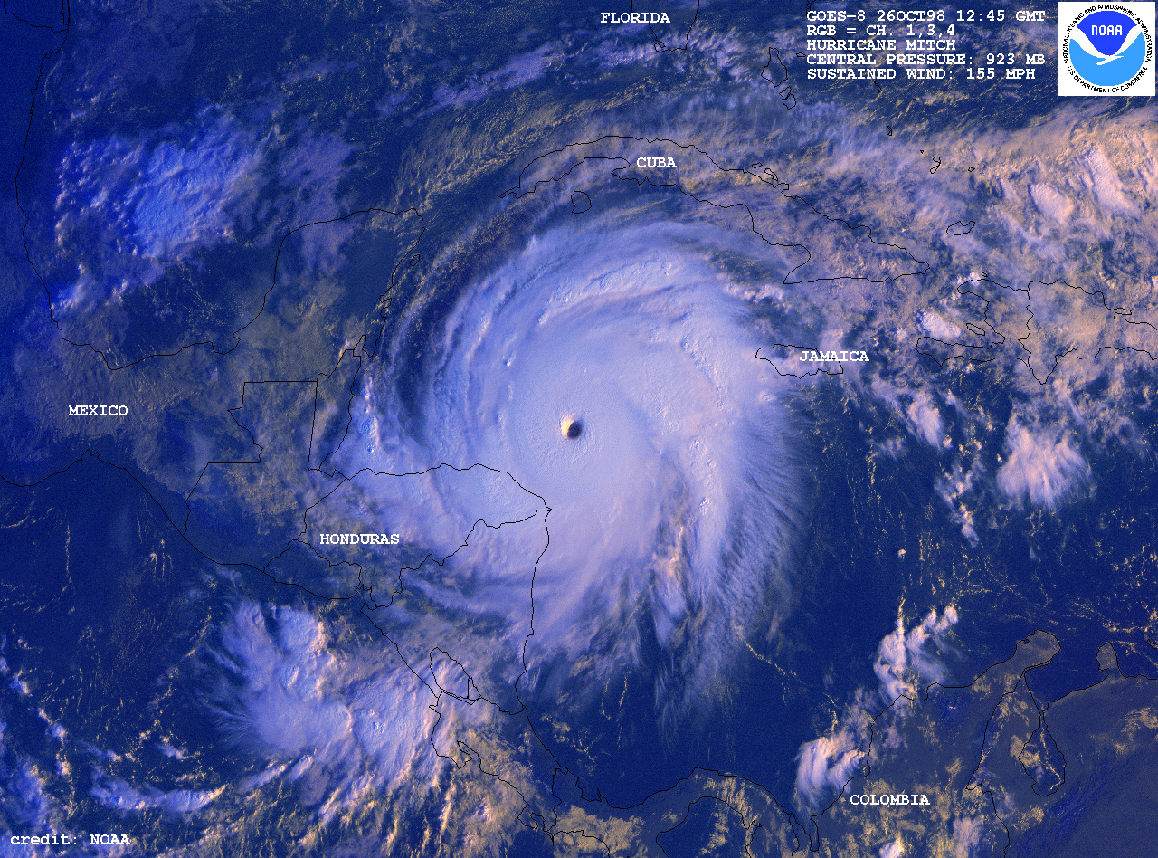
 10/26/98 12:45 UTC | GOES-8 | H4 155 mph
|
Channels 1,3,4 | |
 10/26/98 12:45 UTC | GOES-8 | H4 155 mph
|
Channels 1,3,4 | |
 10/25/98 21:15 UTC | GOES-8 | H4 150 mph
|
Channels 1,3,4 | |
 10/25/98 21:15 UTC | GOES-8 | H4 150 mph
|
Channels 1,3,4 | |
 10/23/98 19:45 UTC | GOES-8 | TS 60 knots
|
Channels 1,2,4 | |
 10/22/98 20:45 UTC | GOES-8 | TS 40 knots
|
Channels 1,2,4 | |
|
|

![]()
These web pages are designed and maintained by
the Operational Significant Event Imagery support team and the
Environmental Applications Team (EAT) of the Satellite Services
Division of NESDIS.
Click here to send e-mail to: osei@noaa.gov
Brought to you by the National Oceanic and Atmospheric Administration (NOAA)