About USGS
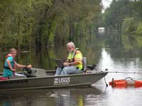
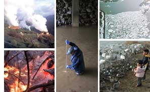
The USGS is a science organization that provides impartial information on the health of our ecosystems and environment, the natural hazards that threaten us, the natural resources we rely on, the impacts of climate and land-use change, and the core science systems that help us provide timely, relevant, and useable information.
Mission
The USGS serves the Nation by providing reliable scientific information to describe and understand the Earth; minimize loss of life and property from natural disasters; manage water, biological, energy, and mineral resources; and enhance and protect our quality of life.
Who We Are
The
USGS employs the best and the brightest experts who bring a range
of earth and life science disciplines to bear on problems. By integrating
our diverse scientific expertise, the USGS is able to understand
complex natural science phenomena and provide scientific products
that lead to solutions. Every day the 10,000 scientists, technicians,
and support staff of the USGS are working for you in more than 400
locations throughout the United States.
What We Do
 As
the Nation's largest water, earth, and biological science and civilian
mapping agency, the U.S. Geological Survey (USGS) collects, monitors,
analyzes, and provides scientific understanding about natural resource
conditions, issues, and problems. The diversity
of our scientific expertise enables us to carry out large-scale,
multi-disciplinary investigations and provide impartial scientific
information to resource managers, planners, and other customers. As
the Nation's largest water, earth, and biological science and civilian
mapping agency, the U.S. Geological Survey (USGS) collects, monitors,
analyzes, and provides scientific understanding about natural resource
conditions, issues, and problems. The diversity
of our scientific expertise enables us to carry out large-scale,
multi-disciplinary investigations and provide impartial scientific
information to resource managers, planners, and other customers.
How We Are Organized
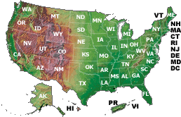 The USGS is organized with a Headquarters in Reston, Virginia. Thousands of USGS employees are working in every State in the Nation, with Regional Executives located in the Southeast, South Central region, Northeast, Midwest, Rocky Mountains, Northwest, Southwest and Alaska. The USGS is organized with a Headquarters in Reston, Virginia. Thousands of USGS employees are working in every State in the Nation, with Regional Executives located in the Southeast, South Central region, Northeast, Midwest, Rocky Mountains, Northwest, Southwest and Alaska.
The following links provide information about our senior leadership,
how we are structured, where we are located, and how to contact
USGS employees:
Our Budget and Peformance
Access primary budget documents,
information about performance measures, and other various management
reports.
Working With Us
There
are a variety of ways to interact with the USGS and its science.
We invite you to explore the following information about doing
business with us, partnering with our science programs, and being
part of the USGS workforce.
Business Opportunities: The USGS is
interested in forming cooperative partnerships with organizations
from all levels of government and industry. The following links
provide information about doing business and partnering with USGS.
Science
Partnerships and Opportunities: Explore the collaborative
work the USGS is doing with other Federal agencies, non-government
organizations, State/local and tribal governments and the
private sector as well as additional opportunites to partner
with us and further our science mission.
Learn
more.
Cooperative Agreements: The USGS
works with many other Federal agencies and the private sector
to accomplish its science mission through formal memorandums
of understanding and memorandums of agreement.
Learn more.
International Activities: The USGS
carries out international activities as a complement to its domestic
programs. Learn more about the scientific and technical assistance
being provided in more than 100 countries.
Learn
more.
Activities Related to Native
Americans: Learn more about the work USGS does in cooperation
with American Indian and Alaska Native governments—including
research on water and mineral resources; animals and plants
important to subsistance the environment, or the economy; natural
hazards; and geologic resources.
Learn
more.
Employment Opportunities: Your
one source for information on job openings, including senior
management positions, student employment, Postdoctoral and Upward
Mobility Programs, and volunteering.
News & Events
USGS uses a variety of traditional and new media tools, including social media, to share information and help the public understand how science addresses some of our Nation’s most pressing issues. We invite you to stay up-to-date with events and news using our Newsroom and various social media tools, and to join our community, tell us what you think, and let us know how we can better serve you!
Our History
 The United States Geological Survey was established on March 3,
1879, just a few hours before the mandatory close of the final
session of the 45th Congress, when President Rutherford B. Hayes
signed the bill appropriating money for sundry civil expenses of
the Federal Government for the fiscal year beginning July 1, 1879. Learn
more. The United States Geological Survey was established on March 3,
1879, just a few hours before the mandatory close of the final
session of the 45th Congress, when President Rutherford B. Hayes
signed the bill appropriating money for sundry civil expenses of
the Federal Government for the fiscal year beginning July 1, 1879. Learn
more.
|
 Who We Are