|
Latest Conditions in |
||||||
|---|---|---|---|---|---|---|
|
Feb 13 |
Overcast |
36°F (2°C) |
||||
- Current Hazards
- Current Conditions
- Forecasts
- Hydrology
- Climate
- Weather Safety
- Additional Info
- Contact Us
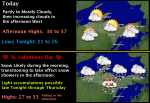
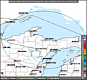
Top News of the Day
Click on the map below for the latest forecast.
Last map update: Wed, Feb. 13, 2013 at 3:31:33 pm EST

|
|
|||||||||||||||||||||||||||||||||||||||||||||||||||||||
Upper Peninsula Photo Gallery |
|---|


| UP Weather History for February 13th recorded at WFO Marquette |