
Earthquake Hazards Program

The USGS Earthquake Hazards Program is part of the National Earthquake Hazards Reduction Program (NEHRP), established by Congress in 1977. We monitor and report earthquakes, assess earthquake impacts and hazards, and research the causes and effects of earthquake.
Latest Earthquakes
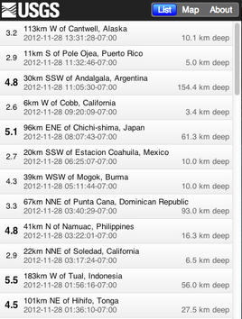
Real-time Earthquake MapInteractive map and list of latest earthquakes
-
Get Real-time Data Sent to You
Get real-time earthquake notifications sent to you using a number of popular mediums: Feeds, Email, Twitter, etc… -
Did You Feel It?
Feel an earthquake? Report it here.
Science Centers
Our scientists study earthquakes around the world. Learn about Science Center activities, research, regional seismic network monitoring, and local activities of interest conducted in our various offices around the US.
Additional Resources
Significant Earthquakes Past 30 Days
- M 5.1, 72km W of Tonopah, Nevada Wednesday, February 13, 2013 00:10:14 UTC
- M 5.1, 24km ENE of Sungjibaegam, North Korea Tuesday, February 12, 2013 02:57:51 UTC
- M 6.3, 51km SW of Lata, Solomon Islands Sunday, February 10, 2013 18:39:35 UTC
- M 6.6, 27km S of Lata, Solomon Islands Saturday, February 09, 2013 21:02:22 UTC
- M 6.9, 5km NNE of Yacuanquer, Colombia Saturday, February 09, 2013 14:16:09 UTC
- M 7.0, 25km SSE of Lata, Solomon Islands Friday, February 08, 2013 15:26:39 UTC
- M 6.8, 21km SSE of Lata, Solomon Islands Friday, February 08, 2013 11:12:13 UTC
- M 6.6, 36km SSW of Lata, Solomon Islands Thursday, February 07, 2013 18:59:16 UTC
- M 6.3, 144km W of Lata, Solomon Islands Wednesday, February 06, 2013 06:35:19 UTC
- M 7.0, 27km NNW of Lata, Solomon Islands Wednesday, February 06, 2013 01:54:15 UTC
- M 7.1, 114km WSW of Lata, Solomon Islands Wednesday, February 06, 2013 01:23:19 UTC
- M 8.0, 76km W of Lata, Solomon Islands Wednesday, February 06, 2013 01:12:27 UTC
- M 6.3, 70km WSW of Lata, Solomon Islands Wednesday, February 06, 2013 00:07:22 UTC
- M 6.9, 19km SSW of Obihiro, Japan Saturday, February 02, 2013 14:17:35 UTC
- M 6.4, 70km SW of Lata, Solomon Islands Friday, February 01, 2013 22:18:33 UTC
- M 6.3, 49km WSW of Lata, Solomon Islands Friday, February 01, 2013 22:16:34 UTC
- M 6.8, 56km NNE of Vallenar, Chile Wednesday, January 30, 2013 20:15:43 UTC
- M 6.1, 60km SE of Kegen, Kazakhstan Monday, January 28, 2013 16:38:53 UTC
Featured Items
-
The Great Central US ShakeOut

You are invited to join millions of people who will Drop, Cover, and Hold On at 10:15am on February 7, 2013 in the 2013 Great Central U.S. ShakeOut!
View News -
Beta Mobile Real-time Earthquakes
Try out our new mobile version of the Real-time Earthquakes Map & List under development now, and provide feedback.
View Site -
The Christchurch Earthquakes Workshop
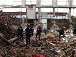
Response and Recovery Lessons from the 2010-2011 Earthquake Sequence in Canterbury, New Zealand. 1-5 pm on February 12, 2013 at the Grand Hyatt Hotel, Seattle, Washington. The public is welcome and invited.
View News -
A Practical Guide to Pacific Northwest Earthquakes
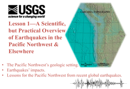
Online 90-minute course on the basics of Pacific NW earthquakes and USGS products for managing earthquakes.
View Site -
New Evidence Shows Power of East Coast Earthquakes
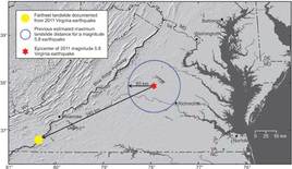
Earthquake shaking in the eastern United States can travel much farther and cause damage over larger areas than previously thought.
View News
