The Search for the Site of the Sand Creek Massacre
By Christine Whitacre
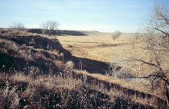
A modern view of the Sand Creek site.
(National Park Service)
On November 29, 1864, approximately seven hundred soldiers led by Col. John Chivington attacked a Cheyenne and Arapaho village in what is now southeastern Colorado. The village, made up of around one hundred lodges, was on the banks of a meandering, intermittent stream known as Sand Creek. Under the leadership of Cheyenne chief Black Kettle, about five hundred Cheyenne and Arapaho people were camped at the site, believing that they were not only at peace with the U.S. government but also under its protection. Nevertheless, Chivington's troops, made up of volunteers from the Colorado First and Third Cavalry, launched a surprise dawn attack that left at least 150 Cheyennes and Arapahos dead— mostly women, children, and the elderly. During that afternoon and the following day, the soldiers followed up the massacre by committing atrocities on the dead before withdrawing from the field. Upon their return to Denver, the soldiers received a heroes' welcome, which included a display of scalps and body parts that had been taken from the Indian victims. Soon, however, the Sand Creek Massacre was recognized for what it was: a national disgrace that was condemned by three separate federal investigations.1
Nearly 135 years after the event, Senator Ben Nighthorse Campbell (R-Colo.), the only Native American member of Congress and a Cheyenne descendant of survivors of the Sand Creek Massacre, sponsored legislation that began the process of memorializing the massacre site. Senator Campbell introduced Senate Bill 1695, which was signed by President Bill Clinton on October 6, 1998, as Public Law 105-243. Known as the Sand Creek Massacre National Historic Site Study Act of 1998, the legislation directed the National Park Service (NPS)— in consultation with the Cheyenne and Arapaho Tribes of Oklahoma, the Northern Cheyenne Tribe, the Northern Arapaho Tribe, and the State of Colorado— to complete two tasks. First, the National Park Service was to verify the location and extent of the Sand Creek Massacre site. Indeed, a lack of conclusive evidence as to the site's location had been the major obstacle to earlier efforts to designate the site. Second, the National Park Service was to evaluate a range of management alternatives for the site, including the feasibility of making the Sand Creek Massacre site a unit of the National Park System. Congress also mandated that the project be completed within eighteen months.
The National Park Service Sand Creek Massacre project team took a wide-ranging multidisciplinary approach to finding the massacre site. As part of the site location effort, Cheyenne and Arapaho descendants of the Sand Creek Massacre, a number of whom were members of the project team, told stories of the massacre that had been handed down to them through the generations. Historians researched maps, diaries, reminiscences, and congressional and military investigative reports for information that might shed light on the location of the massacre. The National Park Service also held public open houses in southeastern Colorado, encouraging local residents to come forward with information, including artifacts found on their land that might be evidence of the massacre. Historical aerial photographs, the earliest dating from the 1930s, were examined for evidence of trails leading to and from the massacre site. Before the archaeological survey got going in May 1999, the NPs team conducted a geomorphological assessment of Sand Creek that identified, through an analysis of soil samples, those specific landforms from which 1864-era artifacts might be recovered.
Archival documentation at the National Archives played a significant role in the successful completion of the Sand Creek Massacre project— which led, ultimately, to Sand Creek's authorization as a national historic site in November 2000. A map drawn by US Army lieutenant Samuel Bonsall in 1868 that was found by archivist Scott Forsythe in the National Archives and Record Administration - Great Lakes Region, was integral to the discovery of the Sand Creek Massacre site. Jerome Greene, NPs lead historian for the site location study, called the map "the most important document yet located to convincingly posit the site of the Sand Creek Massacre."2
Historical Background
The Sand Creek Massacre is one of the most emotionally charged and controversial events in American history; it is also, as Jerome Greene has noted, "a tragedy reflective of its time and place."3 Although army reports of the massacre are grouped with the official records of the Civil War, Sand Creek more closely reflects the vast cultural, social, and political changes that were taking place in the West during the mid-nineteenth century, far removed from the battlefields of Gettysburg and Manassas. The tragedy at Sand Creek was the culmination of several forces, including the Colorado Gold Rush, the ambitions of local politicians and military leaders, the clash of cultures on the western plains, and the claims of different groups of people to the same land.
By the time the Civil War had begun, the Cheyenne and Arapaho people had been on the western plains for decades. Under the terms of the 1851 Treaty of Fort Laramie, Cheyenne and Arapaho territory included much of the front range of Colorado. But major gold strikes in the mountains west of Denver in 1858 and 1859 precipitated a tide of Euro-American immigration. In 1859 William Bent, the well-known trader who also served as the Colorado and Arapaho agent in Colorado, called upon the US government to better define the territorial rights of the Indians in the area. The result was the 1861 Treaty of Fort Wise, by which the Cheyennes and Arapahos surrendered most of their land and received instead a much smaller, triangular-shaped tract along and north of the upper Arkansas River in southeastern Colorado. Sand Creek, also known as Big Sandy Creek, formed the eastern border of this reservation.
But not all Cheyennes and Arapahos recognized the Treaty of Fort Wise, and many refused to abide by it. By the summer of 1864, a number of conflicts between Euro-Americans and Indians heightened an already tense situation within Colorado Territory. Colorado's territorial governor, John Evans, as well as Col. John Chivington, who headed the US Army military district in Colorado, interpreted the attacks upon white settlers as proof that the Indians were preparing for war, even though evidence indicates that they were the actions of warriors acting beyond the control of their chiefs. On June 11, 1864, Arapaho warriors attacked and murdered the Hungate family, thirty miles from Denver. The public display of the family's bodies, which included two young children, terrified Colorado's citizens, many of whom left their ranches to seek protection within the walls of Denver's mint. Two weeks later on June 27, Governor Evans issued a proclamation to all "Friendly Indians of the Plains" to present themselves to assigned military posts. The Cheyennes and Arapahos who wanted to be at peace with the government were told to go to the military authorities at Fort Lyon, which was along the Arkansas River near present-day Lamar, Colorado. Meanwhile, Governor Evans began preparing for military action. On August 11, Evans received permission from federal authorities to raise a regiment of hundred-day US Army volunteers, designated the Third Colorado Cavalry under the command of Colonel Chivington. Also in August, Evans issued a proclamation that contradicted his earlier one to the "Friendly Indians of the Plains," now calling upon citizens to kill all Indians and seize their property.
At the same time that Evans and Chivington were assembling military forces, Cheyenne and Arapaho chiefs were attempting to negotiate a peace settlement. Cheyenne chief Black Kettle contacted Maj. Edward Wynkoop, the commander at Fort Lyon, of his desire for peace. In response, Wynkoop led his command of First Colorado Cavalry to meet Black Kettle and the Arapaho leader, Left Hand, at the big timbers of the Smoky Hill River near Fort Wallace, Kansas. Here, the Cheyenne and Arapaho chiefs turned over several white captives and consented to meet with Evans and Chivington. That meeting took place on September 28 at Camp Weld, outside of Denver. Although the Indians departed Camp Weld believing that they had negotiated a peace settlement, Governor Evans soon notified officials in Washington of the tribes' continued hostilities and noted that "the winter . . . is the most favorable time for their chastisement."4
In late October and early November, the Arapahos and Cheyennes began arriving at Fort Lyon to comply with what they believed were the conditions of the peace settlement. Maj. Scott Anthony, the fort's new commander, instructed the Indians to camp at an area approximately forty miles north-northeast of the fort. Simultaneously, however, the army was already initiating its attack. On November 14, Chivington's troops began marching out of Denver. The troops reached Fort Lyon midday on November 28. At approximately 8 P.M., now joined by troops from Fort Lyon, Chivington's men began an all-night ride towards the Cheyenne and Arapaho encampment on Sand Creek, following an old Indian trail that led to the site.
At dawn on November 29, Chivington's forces, equipped with four twelve-pounder mountain howitzer guns, attacked the village. Many of the villagers who survived the initial attack fled upstream to the north. Approximately one mile above the village, according to most accounts, the Indians sheltered themselves in hastily dug trenches along the banks of the creek. The soldiers followed the Indians to this area, known as the "sandpits," bringing with them at least two mountain howitzers. By day's end, at least 150 Indians had been killed. On the army's side, ten soldiers died. Afterwards, Chivington ordered his men to plunder and burn the village. After the massacre, Cheyenne and Arapaho survivors began making their way northeast to the camps of their kinsmen along the forks of the Smoky Hill River.
Previous Efforts to Locate the Sand Creek Massacre Site
Although most historic accounts of the Sand Creek Massacre placed it at the "Big South Bend" of Sand Creek, its exact location became obscured over time. As Mildred Red Cherries of the Northern Cheyenne noted at project meetings, the Sand Creek Massacre became "lost," even to the descendants of those who had survived the attack. The massacre site was left unmarked and, by the turn of the century, there was little evidence of the terrible events of November 29, 1864. In 1908, army veterans who had participated in the massacre planned a reunion at the site. However, upon reaching the banks of Sand Creek, even they could not agree on its location.
On August 6, 1950, the Colorado Historical Society erected a Sand Creek Massacre historical marker on State Highway 96 near the town of Chivington, Colorado. On that same day, the historical society participated in a second dedication ceremony approximately fifteen miles to the north, on property now owned by Bill and Jredia Dawson. Here, overlooking an approximate 90-degree bend of Sand Creek, the local community placed a second marker, designating it as the site of the massacre. Tribal members also returned to the area, using their traditional tribal knowledge and oral histories to identify the massacre site. In 1978 the Arrow Keeper of the Cheyenne Tribe recognized what is now referred to as the Dawson South Bend as the Sand Creek Massacre site when he blessed it as "Cheyenne earth."
Still, there were those who disagreed that the site had been found. Many observers were troubled by the lack of physical evidence of either the village site or the military's ammunition. In particular, critics questioned why no evidence of Civil War-era ammunition, including twelve-pounder mountain howitzer ordnance, had been found at the Dawson South Bend. The Sand Creek Massacre was the only Civil War - era event in Colorado in which the army used such guns, and many believed that the discovery of howitzer-related artifacts would offer significant proof of the site location.
In the early 1990s, amateur archaeologists and metal detector hobbyists who had surveyed the Dawson South Bend, but had not found artifacts associated with the Sand Creek Massacre, approached the Colorado Historical Society with their findings. In response, the Colorado Historical Society initiated a project to identify the location of the massacre. In 1994 the society asked Richard Ellis of Fort Lewis College, Durango, Colorado, to develop a project to verify the location of the Sand Creek Massacre. As an important first step, Ellis and the Colorado Historical Society began consulting with descendants of Cheyenne victims of the Sand Creek Massacre. In 1997 Ellis also asked archaeologists Douglas Scott of the National Park Service, William Lees of the Oklahoma Historical Society, and Anne Bond of the Colorado Historical Society, in cooperation with other volunteers and metal-detector organizations, to conduct reconnaissance-level archaeological surveys of two possible Sand Creek Massacre sites. The team surveyed the "vee" of the Dawson South Bend as well as another large bend of Sand Creek, often referred to as the "North Bend," which was approximately ten miles north of the Dawson South Bend. But the state-funded Fort Lewis College project was unable to conclusively identify the location of the Sand Creek Massacre site. No 1864-era artifacts were found in the North Bend, and only twelve 1864-era items were found in the Dawson South Bend, either through the 1997 survey or later by the landowner. As a result, although there was now growing interest in designating the Sand Creek Massacre as a national historic site, there was still no definitive physical evidence, or consensus, regarding its location.
National Park Service Efforts to Locate the Site
Following the passage of the Sand Creek Massacre National Historic Site Study Act in October 1998, the responsibility for the Sand Creek Massacre project was delegated to the Intermountain Regional Office of the National Park Service, headquartered in Denver. A project team was assembled that included historians, ethnographers, archaeologists, geomorphologists, and other disciplines.5
As mandated by Congress, the major goal of the Sand Creek Massacre site location study was to map the "location and extent" of the Sand Creek Massacre. One of the team's first tasks was to identify all potential locations of the massacre. The methodology was based on two basic principles. First, all possible sites would be evaluated according to the evidence; there was no presumption as to the "right" location of the massacre site. Second, the project team would follow four major lines of evidence: 1) historical research, 2) oral histories, 3) traditional tribal knowledge, and 4) physical evidence of the site, as determined by reconnaissance-level archaeological survey.
The archaeological survey was scheduled for May 1999. Evaluation of oral histories, traditional tribal methods, aerial photographs, historical research, and geomorphology was to be completed first. The archaeological survey could then focus on those areas that were the most likely locations of the Sand Creek Massacre and which were most likely to have physical evidence of the massacre.
Historical Research
Historical research efforts involved examination of a large number of published and manuscript historical maps for information about streams, trails, roads, land use, ownership, and other data that might help pinpoint the site. Among the most important sources of information were four maps drawn or annotated by George Bent, a mixed-blood Cheyenne survivor of the massacre. One of the maps, drawn by George Hyde and annotated by George Bent, places the Sand Creek Massacre in the North Bend of Sand Creek. As noted earlier, the 1997 state-funded archaeological survey of this area uncovered no massacre-related artifacts.6 The second map, also drawn by Hyde and annotated by Bent, places the massacre site below the confluence of Rush and Sand Creeks, approximately twenty miles south of the Dawson South Bend.7 The remaining two maps, which were drawn by George Bent approximately forty years after the Sand Creek Massacre, focus on the massacre site itself. These maps show the placement of Indian encampments within the village, the location of the sandpits area in relationship to the village, and the troop movements. These two maps, one of which is in the collection of the Oklahoma Historical Society and the other in the archives at the University of Colorado Library at Boulder, also show that the massacre occurred near a 90-degree bend of Sand Creek, a configuration that greatly resembles the Dawson South Bend.8
In addition to the Bent maps, a manuscript map drawn by US Army lieutenant Samuel Bonsall in 1868 also contained significant information that pertained directly to the location of the Sand Creek Massacre.9 In 1992, while processing records associated with nineteenth-century military activities in the Trans-Mississippi West, archivist Scott Forsythe found the Bonsall map in Record Group 77, Records of the Army Corps of Engineers, in the National Archives and Records Administration - Great Lakes Region in Chicago. "It is unusual that records such as the engineering officer records of the Department of the Platte would have found their way into a regional archives facility but, through unknown circumstances, these records ended up with the Chicago district of the Corps of Engineers and were transferred into the holdings of the Great Lakes Region," noted Forsythe. The discovery of the Bonsall map was memorable for Forsythe, because he was well acquainted with Sand Creek and understood the map's reference to "Chivingtons Massacre." A few years after finding the Bonsall map, Forsythe learned of the upcoming State of Colorado-Fort Lewis College project to locate the site of the Sand Creek Massacre. Forsythe subsequently contacted the Colorado Historical Society and, in 1996, sent them a copy of the Bonsall map.10 In 1998, when the National Park Service efforts to locate the Sand Creek Massacre site began, Colorado state historian David Halaas gave a copy of the map to NPs historian Jerome Greene.
The Bonsall map was drawn by 2nd Lt. Samuel W. Bonsall, Third Infantry, who was stationed at Fort Lyon in 1868; the map documents the route of Bonsall's detachment of eleven infantry soldiers from Fort Lyon to Cheyenne Wells, Colorado. Bonsall and his men were escorting Lt. Gen. William T. Sherman east following a tour of frontier sites. The map was prepared in June 1868, within four years of the Sand Creek Massacre, in accordance with US Army regulations. Rendered in the form of a strip map and journal, the map is graphically detailed with regard to landmarks and place names, including time and mileage readings. The map shows the site of "Chivingtons Massacre" in relative placement to two landmarks. Bonsall placed "Chivingtons Massacre" between a point, south of the massacre site, where the road from Fort Lyon crossed Sand Creek, and a point approximately six miles north from it, where that same road branched into "three forks." Between these points, the lieutenant drew a bold line, approximately two miles long, representing the extent of the massacre site.
The significance of the Bonsall map became even more apparent when it was compared to historical aerial photographs of the massacre site. Art Ireland, an NPs archaeologist on the project team, examined a series of historical and contemporary aerial photographs for evidence of landmarks that had been delineated on the Bonsall map. In particular, Ireland searched for segments of the historic trail that the army may have traveled between Fort Lyon and the massacre site, including the point at which it crossed Sand Creek. Ireland also examined the photographs for evidence of "three forks," that point six miles north of the massacre at which the trail branched into three separate routes.
The earliest aerial photographs of the Sand Creek area were taken in 1936 - 1937 by the Soil Conservation Service.11 These photographs, taken nearly seventy years after the massacre, precisely confirm the "three forks" point as delineated on Bonsall's map. The photographs, which indicate that the area had changed relatively little since the time of the account, also clearly show a road leading to and from Fort Lyon. Thus, prior to the archaeological survey of the Sand Creek Massacre site, Greene— primarily based on an analysis of the Bonsall map and its comparison to the 1936 - 1937 aerial photographs— concluded that the village attacked by Chivington's troops on November 29, 1864, was approximately one mile north of the "vee" of the Dawson South Bend, the site traditionally believed to be the massacre site.
Oral Histories
The oral histories of descendants of the Cheyenne and Arapaho survivors of the massacre were significant sources of information. From the beginning of the project, the National Park Service had been committed to the collection of oral historical data as one of the primary lines of evidence in locating the Sand Creek Massacre site. Between April 1999 and February 2000, thirty-two Cheyenne and Arapaho descendants of survivors of the Sand Creek Massacre gave oral history accounts, which they permitted to be recorded and transcribed.12
The Sand Creek Massacre oral history project specifically focused on information that would help identify the location of the massacre site. In particular, descendants were asked specific questions about topics such as geographic landforms, physical descriptions of the size and extent of the Indian encampment, and information on trails that led to the site. Several geographic elements recurred in the oral history interviews. Among these was the often-stated need for the campsite to have been located close to water, both for the people and for their horses. In particular, a number of interviewees said that Cheyennes always followed watercourses and always camped by water. Many said that there was no flowing water in Sand Creek at the time of the massacre. While horses could have drunk from the standing pools, oral history accounts indicated that people would have dug for water or used spring water. Several people emphasized the importance of an available spring as a source of drinking water, noting that it is against traditional Cheyenne belief to drink from a source of water that had been standing overnight. The information on the water source was of particular significance because an extant spring is approximately two miles east of the Dawson South Bend. The proximity of this spring supported the Cheyenne belief that the Dawson South Bend was the area of the Indian encampment.
Interviewees also revealed information on the proximity of the sandpits area to the village site. Several people recounted that the majority of people in the village were women, children, and the elderly, who could not have run very far from their lodges before seeking out hiding places. Other stories noted the presence of rocky hiding places. In particular, Northern Arapaho interviewees gave accounts of limestone outcroppings in the area, which survivors had used as shelter. Several people mentioned the presence of hills and trees near the massacre site. Interviewees also provided details about the size of the encampment, in terms of both geographic space and number of lodges. Many also discussed the makeup of the encampment, particularly the relative placement of the Cheyenne and Arapaho groups. However, with important exceptions— such as the description of the massacre site provided by Southern Cheyenne descendant Laird Cometsevah— geographic details of the massacre site were generally nonspecific as to exact location. (Some interviewees expressed a reluctance to provide more detail because of the often-stated fear of government retribution, extreme emotion, or the belief that the stories belong to the families only.) As NPs ethnographer Alexa Roberts observed, geographic details in the oral histories of the Sand Creek Massacre were peripheral to the descriptions of the atrocities committed during that event. Overwhelmingly, the oral histories provided powerful testimony to the horrors of the events of November 29, 1864, and the devastating effects of the massacre on families and the tribes that linger to this day. Although accounts of physical features associated with the site varied among the oral history accounts, every story shared "the sense of chaos, running, scattering, horror, fear, and blood."13
The Search for the Site of the Sand Creek Massacre, Part 2
Christine Whitacre, a historian with the National Park Service, Intermountain Support Office in Denver, Colorado, served as the team captain for the Sand Creek Massacre Project. She received her M.A. from the University of Colorado and has worked for the National Park Service for eleven years.
| Articles published in Prologue do not necessarily represent the views of NARA or of any other agency of the United States Government. |