
Custom Mapping and Analysis Tools
Quaternary Fault Web Mapping Application
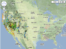
Online Google Maps interface providing an interactive view of the Quaternary Faults for the entire United States.
Custom Hazard Mapping
Replot local portions of the national hazard maps. You define center and span in addition to several other customization parameters.
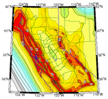
Interactive Hazard Maps

Online SA or PGA maps for 2% or 10% in 50 year probability of exceedance for the US with features you can turn on, off, query and download into a GIS.
EQ Probability Mapping

Map of probability of earthquake larger than given magnitude within selected distance. Earthquake probability maps use the most recent earthquake rate and probability models. These models are derived from earthquake rate, location, and magnitude data from the USGS National Seismic Hazard Mapping Project.
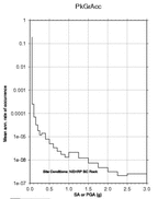
Hazard Curve Application
This application that lets you view hazard curves and dynamically generate uniform hazard response spectra (UHRS). The application also provides instructions for programmatic access to the 2008 National Seismic Hazard Mapping Program data.
Interactive Deaggregation

For a given location, what are the relative contribution for different magnitude-distance combinations. For 1996 fixed cities deaggregation see Deaggregation, Fixed Cities.
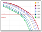
Banded Deaggregation
For a given location, what are the relative contribution for different magnitude-distance combinations. Generates a plot of ground motion in bands vs. rate and a text data file of the hazard matrices for each ground motion band.
Global VS30 Map Server

The Global Vs30 Server allows a user to select from a map or input a rectangular region of interest. It then provides (optionally) a Vs30 grid in ASCII or GMT grid format, and a JPEG Vs30 map.
Other Hazard Software

OpenSHA
OpenSHA is a joint venture between the Southern California Earthquake Center (SCEC), and the USGS. The primary goal of OpenSHA is to improve seismic hazard analysis by providing a platform that can accomodate both past and future models.
