Map
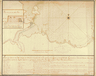
Plano de la rada de Lugan Nuebo situada en la costa de España al ote. del Cabo de Sta. Pola en latd. de 38 gs. 20 ms. con la sonda qe. se ha podido reconocer y las enfilaciones para fondear : lebantado de orden del Sor. Dn. Gabriel de Aristisaba, comte. gral. de esta esquadra qe. biajo a Constantinopla por los pilotos del Navio Triunfante de su mando en el año de 1784 /

| Format |
Map |
|---|---|
| Contributors |
MartíNez NúÑEz, Joseph MartíNez NúñEz, Joseph |
| Dates |
1785 |
| Location |
Mediterranean Coast Santa Pola Region Spain |
| Language |
Castilian Spanish |
| Subjects |
Coasts Manuscript Maps Mediterranean Coast Mediterranean Coast (Spain) Santa Pola Region Santa Pola Region (Spain) Spain |
- Title
- Plano de la rada de Lugan Nuebo situada en la costa de España al ote. del Cabo de Sta. Pola en latd. de 38 gs. 20 ms. con la sonda qe. se ha podido reconocer y las enfilaciones para fondear : lebantado de orden del Sor. Dn. Gabriel de Aristisaba, comte. gral. de esta esquadra qe. biajo a Constantinopla por los pilotos del Navio Triunfante de su mando en el año de 1784 /
- Description
-
Shows coast of Santa Pola region.
-
Relief shown pictorially. Depths shown by soundings.
-
Watermarks: IV, J. Kool, and Strasburg fleur-de-lis.
-
Pen-and-ink.
-
Mounted on cloth backing.
-
LC Luso-Hispanic World, 790
-
Available also through the Library of Congress Web site as a raster image.
-
Includes text.
-
Maggs number annotated in pencil in lower right margin: 89.
-
1 map : ms. ; 50 x 70 cm.
- Creator
- Martínez Núñez, Joseph.
- Created Published
-
[1785]
- Subject Headings
-
-
Santa Pola Region (Spain)
-
-
Coasts--Spain--Santa Pola Region
-
-
Mediterranean Coast (Spain)
-
-
Manuscript maps
-
-
Spain--Santa Pola Region.
-
-
Spain--Mediterranean Coast.
- Notes
-
-
Shows coast of Santa Pola region.
-
-
Relief shown pictorially. Depths shown by soundings.
-
-
Watermarks: IV, J. Kool, and Strasburg fleur-de-lis.
-
-
Pen-and-ink.
-
-
Mounted on cloth backing.
-
-
LC Luso-Hispanic World, 790
-
-
Available also through the Library of Congress Web site as a raster image.
-
-
Includes text.
-
-
Maggs number annotated in pencil in lower right margin: 89.
- Medium
-
1 map : ms. ; 50 x 70 cm.
- Call Number
-
G6564.S48A1 1785 .M3
- Repository
-
Library of Congress Geography and Map Division Washington, D.C. 20540-4650 USA dcu
- Digital Id
-
g6564s lh000790 http://hdl.loc.gov/loc.gmd/g6564s.lh000790
- Library of Congress Catalog Number
- 90683777
Rights & Access
The maps in the Map Collections materials were either published prior to 1922, produced by the United States government, or both (see catalogue records that accompany each map for information regarding date of publication and source). The Library of Congress is providing access to these materials for educational and research purposes and is not aware of any U.S. copyright protection (see Title 17 of the United States Code) or any other restrictions in the Map Collection materials.
Note that the written permission of the copyright owners and/or other rights holders (such as publicity and/or privacy rights) is required for distribution, reproduction, or other use of protected items beyond that allowed by fair use or other statutory exemptions. Responsibility for making an independent legal assessment of an item and securing any necessary permissions ultimately rests with persons desiring to use the item.
More about Copyright and other Restrictions
For guidance about compiling full citations consult Citing Primary Sources.
Part of...
-
Cultural Landscapes
[1623]
-
Geography And Maps Division
[60803]
-
American Memory
[1121009]
More maps like this
-
 Plano del Puerto de Camariñas situado en la costa de Galicia en la latitd. de 43 gros. 36 ms. norte y en la longd. de ...
Site:
American Memory-cultural, Main Catalog
Original Format:
Map
Date:
1750
View catalog record
Plano del Puerto de Camariñas situado en la costa de Galicia en la latitd. de 43 gros. 36 ms. norte y en la longd. de ...
Site:
American Memory-cultural, Main Catalog
Original Format:
Map
Date:
1750
View catalog record
-
 Plano de el Puerto de Corcubión situado al norte de España en el Reyno de Galicia en la latitud de 43 grados y 6 minutos ...
Site:
American Memory-cultural, Main Catalog
Original Format:
Map
Date:
1750
View catalog record
Plano de el Puerto de Corcubión situado al norte de España en el Reyno de Galicia en la latitud de 43 grados y 6 minutos ...
Site:
American Memory-cultural, Main Catalog
Original Format:
Map
Date:
1750
View catalog record
-
 Plano de la ensenada de Lastres situado por observación el cavo del mismo nombre en la latitud N. de 43p0s28ʹ20ʺ /
Contributor:
Puente, Miguel de la
Site:
American Memory-cultural, Main Catalog
Original Format:
Map
Date:
1785
View catalog record
Plano de la ensenada de Lastres situado por observación el cavo del mismo nombre en la latitud N. de 43p0s28ʹ20ʺ /
Contributor:
Puente, Miguel de la
Site:
American Memory-cultural, Main Catalog
Original Format:
Map
Date:
1785
View catalog record
-
 Plano que manifiesta el paso entre las Yslas de Cezarga y la costa de Sn. Adrian con el puerto de Malpica, situada por observación la ...
Contributor:
Auli, Jacobo Felipe
Site:
American Memory-cultural, Main Catalog
Original Format:
Map
Date:
1789
View catalog record
Plano que manifiesta el paso entre las Yslas de Cezarga y la costa de Sn. Adrian con el puerto de Malpica, situada por observación la ...
Contributor:
Auli, Jacobo Felipe
Site:
American Memory-cultural, Main Catalog
Original Format:
Map
Date:
1789
View catalog record
-
 Plano de la Ría de San Yusti situado por obsevación [sic] la punta del N. del Castrón en la latitud N. de 43p0s18ʹ48ʺ /
Contributor:
Puente, Miguel de la
Site:
American Memory-cultural, Main Catalog
Original Format:
Map
Date:
1785
View catalog record
Plano de la Ría de San Yusti situado por obsevación [sic] la punta del N. del Castrón en la latitud N. de 43p0s18ʹ48ʺ /
Contributor:
Puente, Miguel de la
Site:
American Memory-cultural, Main Catalog
Original Format:
Map
Date:
1785
View catalog record
-
 Plano de la Ya. de Sn. Carlos descubierta por Dn. Phelipe Gonzalez de Haedo, Capitan de Fragta. y Comte. del Navio. de S.M. nombrado Sn. ...
Site:
American Memory-cultural, Main Catalog
Original Format:
Map
Date:
1770
View catalog record
Plano de la Ya. de Sn. Carlos descubierta por Dn. Phelipe Gonzalez de Haedo, Capitan de Fragta. y Comte. del Navio. de S.M. nombrado Sn. ...
Site:
American Memory-cultural, Main Catalog
Original Format:
Map
Date:
1770
View catalog record
-
 Plano de la entrada para Guayaquil con todas las yslas y costas de su contorno los quales todaos son Manglares /
Contributor:
Curado, Juan Manuel
Site:
American Memory-cultural, Main Catalog
Original Format:
Map
Date:
1755
View catalog record
Plano de la entrada para Guayaquil con todas las yslas y costas de su contorno los quales todaos son Manglares /
Contributor:
Curado, Juan Manuel
Site:
American Memory-cultural, Main Catalog
Original Format:
Map
Date:
1755
View catalog record
-
 Plano del puerto y río de Guayaquil /
Contributor:
Hervé, Juan de, Hervé, Juan de
Site:
American Memory-cultural, Main Catalog
Original Format:
Map
Date:
1768
View catalog record
Plano del puerto y río de Guayaquil /
Contributor:
Hervé, Juan de, Hervé, Juan de
Site:
American Memory-cultural, Main Catalog
Original Format:
Map
Date:
1768
View catalog record
-
 Plano de las Yslas Malvinas, situado en la latitud sur de 51 grados 28 minutos y en 319 grados 30 minutos lamas leste segun el ...
Site:
American Memory-cultural, Main Catalog
Original Format:
Map
Date:
1700
View catalog record
Plano de las Yslas Malvinas, situado en la latitud sur de 51 grados 28 minutos y en 319 grados 30 minutos lamas leste segun el ...
Site:
American Memory-cultural, Main Catalog
Original Format:
Map
Date:
1700
View catalog record
-
 Plano de la Isla de Sn. Carlos descubierta por Dn. Phelipe Gonzales, Capn. de Fragata de la Rl. Armada, Comandante de el Navio. Sn. Lorenzo, ...
Site:
American Memory-cultural, Main Catalog
Original Format:
Map
Date:
1803
View catalog record
Plano de la Isla de Sn. Carlos descubierta por Dn. Phelipe Gonzales, Capn. de Fragata de la Rl. Armada, Comandante de el Navio. Sn. Lorenzo, ...
Site:
American Memory-cultural, Main Catalog
Original Format:
Map
Date:
1803
View catalog record
-
 Plano de la entrada de Guayaquil situado en la longd. de [blank] y en la latitude [blank] contadas las yslas y costa de su contorno, ...
Site:
American Memory-cultural, Main Catalog
Original Format:
Map
Date:
1700
View catalog record
Plano de la entrada de Guayaquil situado en la longd. de [blank] y en la latitude [blank] contadas las yslas y costa de su contorno, ...
Site:
American Memory-cultural, Main Catalog
Original Format:
Map
Date:
1700
View catalog record
-
 Plano de la aguada de St. Francisco en la ysla de St. Iuan de Puerto Rico. Las dos linias de carmin el punto donde se ...
Contributor:
Celi, Francisco Mathias
Site:
American Memory-cultural, Main Catalog
Original Format:
Map
Date:
1740
View catalog record
Plano de la aguada de St. Francisco en la ysla de St. Iuan de Puerto Rico. Las dos linias de carmin el punto donde se ...
Contributor:
Celi, Francisco Mathias
Site:
American Memory-cultural, Main Catalog
Original Format:
Map
Date:
1740
View catalog record
-
 [Shandong Shengjing hai jiang tu].
Site:
American Memory-cultural, Main Catalog
Original Format:
Map
Date:
1700
View catalog record
[Shandong Shengjing hai jiang tu].
Site:
American Memory-cultural, Main Catalog
Original Format:
Map
Date:
1700
View catalog record
-
 Plano d. las aguadas d. Sn. Juan y Sn. Franco. d. Añasco en la ysla de Pto. Rico, año d. 1787.
Site:
American Memory-cultural, Main Catalog
Original Format:
Map
Date:
1787
View catalog record
Plano d. las aguadas d. Sn. Juan y Sn. Franco. d. Añasco en la ysla de Pto. Rico, año d. 1787.
Site:
American Memory-cultural, Main Catalog
Original Format:
Map
Date:
1787
View catalog record
-
 Plano de la entrada para Guayaquil con todas las yslas y costas de su contorno /
Site:
American Memory-cultural, Main Catalog
Original Format:
Map
Date:
1751
View catalog record
Plano de la entrada para Guayaquil con todas las yslas y costas de su contorno /
Site:
American Memory-cultural, Main Catalog
Original Format:
Map
Date:
1751
View catalog record
-
 Carta esférica de la canal entre Puerto Rico y Santo Domingo /
Site:
American Memory-cultural, Main Catalog
Original Format:
Map
Date:
1793
View catalog record
Carta esférica de la canal entre Puerto Rico y Santo Domingo /
Site:
American Memory-cultural, Main Catalog
Original Format:
Map
Date:
1793
View catalog record
You might also like
-

 Shore processes and shoreline development,
Contributor:
Johnson, Douglas Wilson
Site:
Main Catalog
Original Format:
Book
Date:
1919
Shore processes and shoreline development,
Contributor:
Johnson, Douglas Wilson
Site:
Main Catalog
Original Format:
Book
Date:
1919
-
Introduction to coastal processes and geomorphology /
Contributor:
Davidson-Arnott, R.
Site:
Main Catalog
Original Format:
Book
Date:
2010
-
 Rock islands with birds and algae [in the Pacific Ocean off the coast of] Monterey, California
Site:
American Memory-cultural
Original Format:
Photo, Print, Drawing
Rock islands with birds and algae [in the Pacific Ocean off the coast of] Monterey, California
Site:
American Memory-cultural
Original Format:
Photo, Print, Drawing
-
 Tidal bluffs [and an] exposed coast, Savin Rock, Connecticut
Site:
American Memory-cultural
Original Format:
Photo, Print, Drawing
Date:
1932
Tidal bluffs [and an] exposed coast, Savin Rock, Connecticut
Site:
American Memory-cultural
Original Format:
Photo, Print, Drawing
Date:
1932
-
 [The] windward [side of the island of] Molokai, Hawaii
Site:
American Memory-cultural
Original Format:
Photo, Print, Drawing
[The] windward [side of the island of] Molokai, Hawaii
Site:
American Memory-cultural
Original Format:
Photo, Print, Drawing
-
 Northeast coast of [the island of] Hawaii
Contributor:
Kraus, E. J. (Ezra Jacob)
Site:
American Memory-cultural
Original Format:
Photo, Print, Drawing
Date:
1936
Northeast coast of [the island of] Hawaii
Contributor:
Kraus, E. J. (Ezra Jacob)
Site:
American Memory-cultural
Original Format:
Photo, Print, Drawing
Date:
1936