Map
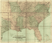
Extract from a map entitled portions of the military departments of the Cumberland . . . of the South . . . and of the Gulf . . .

| Format |
Map |
|---|---|
| Contributors |
Callahan, Denis |
| Dates |
1863 |
| Location |
Southern States United States |
| Language |
English |
| Subjects |
Southern States United States |
- Title
- Extract from a map entitled portions of the military departments of the Cumberland . . . of the South . . . and of the Gulf . . .
- Description
-
Scale 1:350,000.
-
LC Civil War Maps (2nd ed.), 37.4
-
Map extends from Tallahassee, Florida, west to Mobile, Alabama, and the Gulf coast north to Montgomery, Alabama. Depicted are cities and towns, forts, three classes of roads, existing and contemplated railroads, swamps and prairies, river basin, mills, and a few points of historical interest.
-
Includes a list of authorities used in making the map.
-
Description derived from published bibliography.
-
Available also through the Library of Congress web site as raster image.
-
1 map 94 x 116 cm.
- Creator
- Callahan, Denis.
- Created Published
-
New York Bureau of Engineers, War Department 1863.
- Subject Headings
-
-
Southern States
-
-
United States--Southern States.
- Notes
-
-
Scale 1:350,000.
-
-
LC Civil War Maps (2nd ed.), 37.4
-
-
Map extends from Tallahassee, Florida, west to Mobile, Alabama, and the Gulf coast north to Montgomery, Alabama. Depicted are cities and towns, forts, three classes of roads, existing and contemplated railroads, swamps and prairies, river basin, mills, and a few points of historical interest.
-
-
Includes a list of authorities used in making the map.
-
-
Description derived from published bibliography.
-
-
Available also through the Library of Congress web site as raster image.
- Medium
-
1 map 94 x 116 cm.
- Call Number
-
G3865 1863 .C3
- Repository
-
Library of Congress Geography and Map Division Washington, D.C. 20540-4650 dcu
- Digital Id
-
g3865 cw0037400 http://hdl.loc.gov/loc.gmd/g3865.cw0037400
- Library of Congress Catalog Number
- 99447108
Rights & Access
The maps in the Map Collections materials were either published prior to 1922, produced by the United States government, or both (see catalogue records that accompany each map for information regarding date of publication and source). The Library of Congress is providing access to these materials for educational and research purposes and is not aware of any U.S. copyright protection (see Title 17 of the United States Code) or any other restrictions in the Map Collection materials.
Note that the written permission of the copyright owners and/or other rights holders (such as publicity and/or privacy rights) is required for distribution, reproduction, or other use of protected items beyond that allowed by fair use or other statutory exemptions. Responsibility for making an independent legal assessment of an item and securing any necessary permissions ultimately rests with persons desiring to use the item.
More about Copyright and other Restrictions
For guidance about compiling full citations consult Citing Primary Sources.
Part of...
-
Civil War Maps
[2281]
-
Military Battles And Campaigns Cartographic Items
[3867]
-
Geography And Maps Division
[60803]
-
American Memory
[1121009]
More maps like this
-
 Northwestern Georgia (with portions of the adjoining States of Tennessee and Alabama) being part of the Department of the Cumberland.
Contributor:
Callahan, Denis
Site:
American Memory-cultural, Main Catalog
Original Format:
Map
Date:
1864
View catalog record
Northwestern Georgia (with portions of the adjoining States of Tennessee and Alabama) being part of the Department of the Cumberland.
Contributor:
Callahan, Denis
Site:
American Memory-cultural, Main Catalog
Original Format:
Map
Date:
1864
View catalog record
-
 Northwestern Georgia (with portions of the adjoining States of Tennessee and Alabama) being part of the Department of the Cumberland /
Contributor:
Callahan, Denis
Site:
American Memory-cultural, Main Catalog
Original Format:
Map
Date:
1864
View catalog record
Northwestern Georgia (with portions of the adjoining States of Tennessee and Alabama) being part of the Department of the Cumberland /
Contributor:
Callahan, Denis
Site:
American Memory-cultural, Main Catalog
Original Format:
Map
Date:
1864
View catalog record
-
 Passages of the Rappahannock and Battle of Fredericksburg, December 10th to 16th, 1862 : copied from the original belonging to Gen'l. Burnside /
Contributor:
Callahan, Denis
Site:
American Memory-cultural
Original Format:
Map
Date:
1863
Passages of the Rappahannock and Battle of Fredericksburg, December 10th to 16th, 1862 : copied from the original belonging to Gen'l. Burnside /
Contributor:
Callahan, Denis
Site:
American Memory-cultural
Original Format:
Map
Date:
1863
-
 Colton's map of the southern states : including Maryland, Delaware, Virginia, Kentucky, Tennessee, Missouri, North Carolina, South Carolina, Georgia, Alabama, Mississippi, Arkansas, Louisiana, Texas : ...
Contributor:
Colton, J. H.
Site:
American Memory-cultural, Main Catalog
Original Format:
Map
Date:
1862
View catalog record
Colton's map of the southern states : including Maryland, Delaware, Virginia, Kentucky, Tennessee, Missouri, North Carolina, South Carolina, Georgia, Alabama, Mississippi, Arkansas, Louisiana, Texas : ...
Contributor:
Colton, J. H.
Site:
American Memory-cultural, Main Catalog
Original Format:
Map
Date:
1862
View catalog record
-
 The Confederate states, with the border states & the adjoining portion of the Federal states
Contributor:
Bartholomew, John
Site:
American Memory-cultural, Main Catalog
Original Format:
Map
Date:
1864
View catalog record
The Confederate states, with the border states & the adjoining portion of the Federal states
Contributor:
Bartholomew, John
Site:
American Memory-cultural, Main Catalog
Original Format:
Map
Date:
1864
View catalog record
-
 Lloyd's new military map of the border & southern states
Contributor:
Hall, Edward S.
Site:
American Memory-cultural, Main Catalog
Original Format:
Map
Date:
1863
View catalog record
Lloyd's new military map of the border & southern states
Contributor:
Hall, Edward S.
Site:
American Memory-cultural, Main Catalog
Original Format:
Map
Date:
1863
View catalog record
-
 Colton's map of the southern states. Including Maryland, Delaware, Virginia, Kentucky, Tennessee, Missouri, North Carolina, South Carolina, Georgia, Alabama, Mississippi, Arkansas, Louisiana, Texas. Showing also ...
Contributor:
Colton, J. H.
Site:
American Memory-cultural, Main Catalog
Original Format:
Map
Date:
1861
View catalog record
Colton's map of the southern states. Including Maryland, Delaware, Virginia, Kentucky, Tennessee, Missouri, North Carolina, South Carolina, Georgia, Alabama, Mississippi, Arkansas, Louisiana, Texas. Showing also ...
Contributor:
Colton, J. H.
Site:
American Memory-cultural, Main Catalog
Original Format:
Map
Date:
1861
View catalog record
-
 Map of the Confederate States of America. [1861-65]
Contributor:
Lee, Fitzhugh
Site:
American Memory-cultural, Main Catalog
Original Format:
Map
Date:
1910
View catalog record
Map of the Confederate States of America. [1861-65]
Contributor:
Lee, Fitzhugh
Site:
American Memory-cultural, Main Catalog
Original Format:
Map
Date:
1910
View catalog record
-
 Map of the military Department of the Gulf /
Contributor:
D'Avignon, Francis
Site:
American Memory-cultural, Main Catalog
Original Format:
Map
Date:
1864
View catalog record
Map of the military Department of the Gulf /
Contributor:
D'Avignon, Francis
Site:
American Memory-cultural, Main Catalog
Original Format:
Map
Date:
1864
View catalog record
-
 Lloyd's map of the southern states : showing all the railroads, their stations & distances, also the counties, towns, villages, harbors, rivers, and forts.
Contributor:
Lloyd, James T.
Site:
American Memory-cultural, Main Catalog
Original Format:
Map
Date:
1861
View catalog record
Lloyd's map of the southern states : showing all the railroads, their stations & distances, also the counties, towns, villages, harbors, rivers, and forts.
Contributor:
Lloyd, James T.
Site:
American Memory-cultural, Main Catalog
Original Format:
Map
Date:
1861
View catalog record
-
 Lloyd's map of the southern states showing all the railroads, their stations & distances, also the counties, towns, villages, harbors, rivers, and forts.
Contributor:
Lloyd, James T.
Site:
American Memory-cultural, Main Catalog
Original Format:
Map
Date:
1861
View catalog record
Lloyd's map of the southern states showing all the railroads, their stations & distances, also the counties, towns, villages, harbors, rivers, and forts.
Contributor:
Lloyd, James T.
Site:
American Memory-cultural, Main Catalog
Original Format:
Map
Date:
1861
View catalog record
-
 The theatre of war or the stage as set for the opening scenes of 1861
Contributor:
Philadelphia Publishing Company
Site:
American Memory-cultural, Main Catalog
Original Format:
Map
Date:
1893
View catalog record
The theatre of war or the stage as set for the opening scenes of 1861
Contributor:
Philadelphia Publishing Company
Site:
American Memory-cultural, Main Catalog
Original Format:
Map
Date:
1893
View catalog record
-
 Map of the southern states, including rail roads, county towns, state capitals, count roads, the southern coast from Delaware to Texas, showing the harbors, inlets, ...
Contributor:
Bacon & Co
Site:
American Memory-cultural, Main Catalog
Original Format:
Map
Date:
1863
View catalog record
Map of the southern states, including rail roads, county towns, state capitals, count roads, the southern coast from Delaware to Texas, showing the harbors, inlets, ...
Contributor:
Bacon & Co
Site:
American Memory-cultural, Main Catalog
Original Format:
Map
Date:
1863
View catalog record
-
 Perrine's New military map illustrating the seat of war : [southern U.S.]
Contributor:
Perrine, C. O.
Site:
American Memory-cultural, Main Catalog
Original Format:
Map
Date:
1862
View catalog record
Perrine's New military map illustrating the seat of war : [southern U.S.]
Contributor:
Perrine, C. O.
Site:
American Memory-cultural, Main Catalog
Original Format:
Map
Date:
1862
View catalog record
-
 [Eastern Tennessee, with parts of Alabama, Georgia, South Carolina, North Carolina, Virginia, and Kentucky]
Contributor:
United States Coast Survey
Site:
American Memory-cultural, Main Catalog
Original Format:
Map
Date:
1865
View catalog record
[Eastern Tennessee, with parts of Alabama, Georgia, South Carolina, North Carolina, Virginia, and Kentucky]
Contributor:
United States Coast Survey
Site:
American Memory-cultural, Main Catalog
Original Format:
Map
Date:
1865
View catalog record
-
 Sketch map of United States of North-America. [1861-65]
Contributor:
Rundall, Frank M.
Site:
American Memory-cultural, Main Catalog
Original Format:
Map
Date:
1901
View catalog record
Sketch map of United States of North-America. [1861-65]
Contributor:
Rundall, Frank M.
Site:
American Memory-cultural, Main Catalog
Original Format:
Map
Date:
1901
View catalog record
You might also like
-

 The Old South, a monograph,
Contributor:
Hamill, H. M.
Site:
Main Catalog
Original Format:
Book
Date:
1904
The Old South, a monograph,
Contributor:
Hamill, H. M.
Site:
Main Catalog
Original Format:
Book
Date:
1904
-
The old South
Contributor:
Hamill, H. M.
Site:
American Memory-cultural
Original Format:
Book
Date:
1904
-
Problems of the present South; a discussion of certain of the educational, industrial and political issues in the southern states,
Contributor:
Murphy, Edgar Gardner
Site:
Main Catalog
Original Format:
Book
Date:
1904
-
-
The recent past from a southern standpoint. Reminiscences of a grandfather.
Contributor:
Wilmer, Richard H.
Site:
Main Catalog
Original Format:
Book
Date:
1887
-
A journey in the seaboard slave states : with remarks on their economy /
Contributor:
Olmsted, Frederick Law
Site:
Main Catalog
Original Format:
Book
Date:
1856