Map
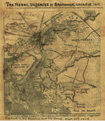
Map showing the investment and siege of Savannah, Georgia by Genl Sherman's army Decr 1864.

| Format |
Map |
|---|---|
| Contributors |
Sneden, Robert Knox |
| Dates |
1861 |
| Location |
Georgia Savannah United States |
| Language |
English |
| Subjects |
Civil War Georgia History Savannah Savannah (Ga.) Siege Siege Warfare United States |
- Title
- Map showing the investment and siege of Savannah, Georgia by Genl Sherman's army Decr 1864.
- Description
-
"Savannah had a population of about 25,00 [and] was strongly fortified and held by Rebel Genl. Hardee with an army of 15,000. These evacuated the city escaping by pontoon bridge to the Union causeway to Charleston, S.C. The city was surrendered by the mayor. The two rebel ironclad rams in the harbor were blown up by the rebels before leaving"--Page caption.
-
Color coding indicates the location of Union and Confederate forces.
-
NOTE: Researchers will be served a color photocopy of this scrapbook image.
-
This item is from the collections of the Virginia Historical Society; please contact the institution for more information.
-
Regional view of Savannah, Ga., with the many landforms (rivers, sounds, swamps, islands) noted as well as the locations of forts Jackson and Pulaski. The Savannah & Gulf Railroad, Georgia Central Railroad, and Ogeechee Canal are also indicated.
-
Available also through the Library of Congress web site as a raster image.
-
In the Robert Knox Sneden Scrapbook (Mss5:7 Sn237:1 p. 378).
-
Manuscripts
-
1 map : pen-and-ink and watercolor ; 16.5 x 23.5 cm.
- Creator
- Sneden, Robert Knox, 1832-1918.
- Created Published
-
[1864-1865]
- Subject Headings
-
-
Siege warfare--History--Civil War, 1861-1865--United States
-
-
Georgia--History--Civil War, 1861-1865
-
-
Savannah (Ga.)--History--Siege, 1864
-
-
United States--Georgia--Savannah.
- Notes
-
-
"Savannah had a population of about 25,00 [and] was strongly fortified and held by Rebel Genl. Hardee with an army of 15,000. These evacuated the city escaping by pontoon bridge to the Union causeway to Charleston, S.C. The city was surrendered by the mayor. The two rebel ironclad rams in the harbor were blown up by the rebels before leaving"--Page caption.
-
-
Color coding indicates the location of Union and Confederate forces.
-
-
NOTE: Researchers will be served a color photocopy of this scrapbook image.
-
-
This item is from the collections of the Virginia Historical Society; please contact the institution for more information.
-
-
Regional view of Savannah, Ga., with the many landforms (rivers, sounds, swamps, islands) noted as well as the locations of forts Jackson and Pulaski. The Savannah & Gulf Railroad, Georgia Central Railroad, and Ogeechee Canal are also indicated.
-
-
Available also through the Library of Congress web site as a raster image.
-
-
In the Robert Knox Sneden Scrapbook (Mss5:7 Sn237:1 p. 378).
-
-
Manuscripts
- Medium
-
1 map : pen-and-ink and watercolor ; 16.5 x 23.5 cm.
- Repository
-
Virginia Historical Society, P.O. Box 7311, Richmond, VA 23221-0311 USA vau
- Digital Id
-
gvhs01 vhs00310 http://hdl.loc.gov/loc.ndlpcoop/gvhs01.vhs00310
Rights & Access
The maps in the Map Collections materials were either published prior to 1922, produced by the United States government, or both (see catalogue records that accompany each map for information regarding date of publication and source). The Library of Congress is providing access to these materials for educational and research purposes and is not aware of any U.S. copyright protection (see Title 17 of the United States Code) or any other restrictions in the Map Collection materials.
Note that the written permission of the copyright owners and/or other rights holders (such as publicity and/or privacy rights) is required for distribution, reproduction, or other use of protected items beyond that allowed by fair use or other statutory exemptions. Responsibility for making an independent legal assessment of an item and securing any necessary permissions ultimately rests with persons desiring to use the item.
More about Copyright and other Restrictions
For guidance about compiling full citations consult Citing Primary Sources.
Part of...
-
Civil War Maps
[2281]
-
Military Battles And Campaigns Cartographic Items
[3867]
-
Geography And Maps Division
[60803]
-
American Memory
[1121009]
More maps like this
-
 Map of the siege and investment of Savannah, Georgia, 5th to 20th Decr. 1864.
Contributor:
Sneden, Robert Knox
Site:
American Memory-cultural
Original Format:
Map
Date:
1861
Map of the siege and investment of Savannah, Georgia, 5th to 20th Decr. 1864.
Contributor:
Sneden, Robert Knox
Site:
American Memory-cultural
Original Format:
Map
Date:
1861
-
 The Defences [sic] of Savannah, Georgia, November 1864.
Contributor:
Sneden, Robert Knox
Site:
American Memory-cultural
Original Format:
Map
Date:
1864
The Defences [sic] of Savannah, Georgia, November 1864.
Contributor:
Sneden, Robert Knox
Site:
American Memory-cultural
Original Format:
Map
Date:
1864
-
 Plan of the Rebel prison pen at Savannah Georgia, Lt. S. R. Davis, C.S.A., Commandant, Sept. 1864.
Contributor:
Sneden, Robert Knox
Site:
American Memory-cultural
Original Format:
Map
Date:
1861
Plan of the Rebel prison pen at Savannah Georgia, Lt. S. R. Davis, C.S.A., Commandant, Sept. 1864.
Contributor:
Sneden, Robert Knox
Site:
American Memory-cultural
Original Format:
Map
Date:
1861
-
 The Rebel defences [sic] of Savannah, Georgia, 1864
Contributor:
Sneden, Robert Knox
Site:
American Memory-cultural
Original Format:
Map
Date:
1862
The Rebel defences [sic] of Savannah, Georgia, 1864
Contributor:
Sneden, Robert Knox
Site:
American Memory-cultural
Original Format:
Map
Date:
1862
-
 Sherman's march from Atlanta to the sea. Drawn from official map of Brig. Genl. O. M. Poe, Chief Engineer.
Contributor:
Sneden, Robert Knox
Site:
American Memory-cultural
Original Format:
Map
Date:
1861
Sherman's march from Atlanta to the sea. Drawn from official map of Brig. Genl. O. M. Poe, Chief Engineer.
Contributor:
Sneden, Robert Knox
Site:
American Memory-cultural
Original Format:
Map
Date:
1861
-
 The Rebel defences [sic] of Savannah, Georgia, Nov. 1864.
Contributor:
Sneden, Robert Knox
Site:
American Memory-cultural
Original Format:
Map
Date:
1861
The Rebel defences [sic] of Savannah, Georgia, Nov. 1864.
Contributor:
Sneden, Robert Knox
Site:
American Memory-cultural
Original Format:
Map
Date:
1861
-
 The Investment of Petersburg, Va. Shewing [sic] battlefield of 5 Forks and Hatcher's Run, Friday March 31st, Saturday April 1st & Sunday April 2nd 1865.
Contributor:
Sneden, Robert Knox
Site:
American Memory-cultural
Original Format:
Map
Date:
1865
The Investment of Petersburg, Va. Shewing [sic] battlefield of 5 Forks and Hatcher's Run, Friday March 31st, Saturday April 1st & Sunday April 2nd 1865.
Contributor:
Sneden, Robert Knox
Site:
American Memory-cultural
Original Format:
Map
Date:
1865
-
 Attack on Ft. Pulaski Savannah, Georgia, April 1862.
Contributor:
Sneden, Robert Knox
Site:
American Memory-cultural
Original Format:
Map
Date:
1862
Attack on Ft. Pulaski Savannah, Georgia, April 1862.
Contributor:
Sneden, Robert Knox
Site:
American Memory-cultural
Original Format:
Map
Date:
1862
-
 Copy of official plan of the siege of Fort Pulaski. Cockspur Island. Savannah Georgia April 1862 : by Union forces under Genl Gillmore and Hunter.
Contributor:
Sneden, Robert Knox
Site:
American Memory-cultural
Original Format:
Map
Date:
1862
Copy of official plan of the siege of Fort Pulaski. Cockspur Island. Savannah Georgia April 1862 : by Union forces under Genl Gillmore and Hunter.
Contributor:
Sneden, Robert Knox
Site:
American Memory-cultural
Original Format:
Map
Date:
1862
-
 Map of siege of Fort Pulaski : Savannah River Georgia. 1862.
Contributor:
Sneden, Robert Knox
Site:
American Memory-cultural
Original Format:
Map
Date:
1862
Map of siege of Fort Pulaski : Savannah River Georgia. 1862.
Contributor:
Sneden, Robert Knox
Site:
American Memory-cultural
Original Format:
Map
Date:
1862
-
 Battery on Turner's rocks : [Georgia].
Site:
American Memory-cultural, Main Catalog
Original Format:
Map
Date:
1864
View catalog record
Battery on Turner's rocks : [Georgia].
Site:
American Memory-cultural, Main Catalog
Original Format:
Map
Date:
1864
View catalog record
-
 [Plan of the fortifications on Causten's Bluff, Georgia].
Site:
American Memory-cultural, Main Catalog
Original Format:
Map
Date:
1864
View catalog record
[Plan of the fortifications on Causten's Bluff, Georgia].
Site:
American Memory-cultural, Main Catalog
Original Format:
Map
Date:
1864
View catalog record
-
 Fort McAllister : [Georgia].
Site:
American Memory-cultural, Main Catalog
Original Format:
Map
Date:
1864
View catalog record
Fort McAllister : [Georgia].
Site:
American Memory-cultural, Main Catalog
Original Format:
Map
Date:
1864
View catalog record
-
 [Savannah and its environs.
Site:
American Memory-cultural, Main Catalog
Original Format:
Map
Date:
1779
View catalog record
[Savannah and its environs.
Site:
American Memory-cultural, Main Catalog
Original Format:
Map
Date:
1779
View catalog record
-
 Siège de Savannah fait par les troupes françoises aux ordres du général d'Estaing vice-amiral de France, en 7.bre, et 8.bre 1779.
Contributor:
Ozanne, Pierre
Site:
American Memory-cultural, Main Catalog
Original Format:
Map
Date:
1779
View catalog record
Siège de Savannah fait par les troupes françoises aux ordres du général d'Estaing vice-amiral de France, en 7.bre, et 8.bre 1779.
Contributor:
Ozanne, Pierre
Site:
American Memory-cultural, Main Catalog
Original Format:
Map
Date:
1779
View catalog record
-
 Map showing the defences of Savannah, on the approaches of Wilmington and Savannah Rivers, Georgia. Flag St[eame]r "Harvest Moon" Feb. 8th 1865.
Contributor:
United States. Navy
Site:
American Memory-cultural, Main Catalog
Original Format:
Map
Date:
1865
View catalog record
Map showing the defences of Savannah, on the approaches of Wilmington and Savannah Rivers, Georgia. Flag St[eame]r "Harvest Moon" Feb. 8th 1865.
Contributor:
United States. Navy
Site:
American Memory-cultural, Main Catalog
Original Format:
Map
Date:
1865
View catalog record
You might also like
-
 Sherman's advance on Savannah, gallop (sic)
Contributor:
Hagenbach, H. E., Composer
Site:
Performing Arts Encyclopedia
Original Format:
Music Score
Date:
1864
Sherman's advance on Savannah, gallop (sic)
Contributor:
Hagenbach, H. E., Composer
Site:
Performing Arts Encyclopedia
Original Format:
Music Score
Date:
1864
-
 Shermans Savannah march
Contributor:
Bowers, Lizzie, Composer
Site:
Performing Arts Encyclopedia
Original Format:
Music Score
Date:
1865
Shermans Savannah march
Contributor:
Bowers, Lizzie, Composer
Site:
Performing Arts Encyclopedia
Original Format:
Music Score
Date:
1865
-

 The siege of Savannah in December, 1864, and the Confederate operations in Georgia and the third military district of South Carolina during General Sherman's march ...
Contributor:
Jones, Charles C.
Site:
Main Catalog
Original Format:
Book
Date:
1874
The siege of Savannah in December, 1864, and the Confederate operations in Georgia and the third military district of South Carolina during General Sherman's march ...
Contributor:
Jones, Charles C.
Site:
Main Catalog
Original Format:
Book
Date:
1874
-
 View of Fort McAlister (i.e. McAllister), Ga., looking up the Ogechee (i.e. Ogeechee) River
Contributor:
Cooley, Sam A. (Samuel A.), Cooley, Sam A.
Site:
Prints & Photographs, Main Catalog
Original Format:
Photo, Print, Drawing
Date:
1864
View catalog record
View of Fort McAlister (i.e. McAllister), Ga., looking up the Ogechee (i.e. Ogeechee) River
Contributor:
Cooley, Sam A. (Samuel A.), Cooley, Sam A.
Site:
Prints & Photographs, Main Catalog
Original Format:
Photo, Print, Drawing
Date:
1864
View catalog record
-
The Siege of Savannah in December, 1864, and the Confederate operations in Georgia and the third military district of South Carolina during General Sherman's march ...
Contributor:
Jones, Charles Colcock
Site:
American Memory-cultural
Original Format:
Book
Date:
1875
-
 Battery schottisch
Contributor:
Bechter, Hermann, Composer
Site:
Performing Arts Encyclopedia
Original Format:
Music Score
Date:
1863
Battery schottisch
Contributor:
Bechter, Hermann, Composer
Site:
Performing Arts Encyclopedia
Original Format:
Music Score
Date:
1863